


Wyvern
Wyvern
About
- Username
- Wyvern
- Joined
- Visits
- 3,267
- Last Active
- Roles
- Member
- Points
- 5,585
- Rank
- Cartographer
- Badges
- 24
Latest Images


-
Community Atlas: Map for the Duin Elisyr area, Doriant
Been MIA for most of this week thanks to RL things. However, another short update.
More tweaking of effects, and adding new, mostly minor, items, along with some new small outdoor patches for the upper tunnel exits this time. I also added some floors to the basal hex-rooms, to make them sit a little better there.
While experimenting with the bevel edge lines for the upper tunnel inner ledges, I chanced upon a better looking option for those raised areas in the southern entrance cave too. I also ended up redrawing both the floors for the upper exit tunnels, so the bevel would work there, and the walls for those same three upper caves. The latter showed up as a problem when I added some of the outside dirt texture patches, as it was suddenly obvious there were some unwanted lines and pseudo-gaps in the wall lines due to the classic "too many nodes" problem. For some reason, the Break command wouldn't work on those two right-hand edge corner exits, possibly because I couldn't identify exactly where the lines were due to the nodal weirdness, and trying to delete nodes turned into a complete nightmare, as some of the lines looked almost as if they had gone around the entire map-border-line edge. So I just cut my losses, deleted all those wall lines, created a new drawing tool to prepare identical, but open-ended, wall-lines to those in the default cave tool, and redrew the lines by tracing the cave floor areas and, without tracing, to a little beyond the map border.
This amount of time-consuming, if relatively minor, amendments is pretty typical for this stage of the drawing process, I find, as it's among the most important elements to get as right as possible.
Ran out of time to get the hex-room doorways cut, with labelling and a scale-grid to follow. After that, it'll be time to start the area map for where this map's going to go in the Atlas...


-
Latest Update Won't Download
One of the Twitch livestreams I follow more regularly runs out of New York City, and they seem to have endless problems with their Internet connectivity. I gather from what's been said that this is a particular NYC thing, where each few city blocks ends up trapped with only one available ISP, so even complaining doesn't help, as you can't threaten to switch to a different provider.
And don't get me started on those dratted "Captcha" things. Great, images so tiny I can't even guess what they might be showing, and you want me to identify a what in each of them (US terms do not always travel well, folks...)?
![[Deleted User]](https://secure.gravatar.com/avatar/c75d9a245b74d9c59be0999ea81ca541/?default=https%3A%2F%2Fvanillicon.com%2F92add7f8c954488718110edc4896ad39_200.png&rating=g&size=200)

-
[WIP] The Dancing Princess (Community Atlas, Artemisia, Spiros Isle, Helinesa)
I'm not saying it will definitely help, as I'm not sure what changes were made when the Ships Annual was updated, as they were drawn only using the original, but I had to handle similar deck-level elements, and other features, when designing "The Naughty Lass" for the Atlas. For ease, you can pick up the deck plans FCW here, and the sideview here, in case those may assist.
Note though that I did "cheat" with the yards, by having them piercing their respective masts, partly because it's a magical vessel, partly because I was trying to avoid needing to show the complexities of the rigging...

-
Map of Narnia
Helen, you can find that map, and many other illustrations, on the Pauline Baynes website. She was an amazing lady who did a huge number of illustrations, including the only ones of Middle Earth not drawn by Tolkien himself during his lifetime which he authorised.
This map, and that for Middle Earth, were available as posters at one time, as I used to have both. They are true works of art!
Plus, she also did all the maps and illustrations for all of Lewis's "Narnia" books. There is, or was, a single volume hardcover at one stage which had all the texts, maps and illustrations in, all in colour, if I recall correctly.

-
Real World Overlays
@roflo1 commented: "I was browsing the Annuals pages, and stumbled upon this:
https://www.profantasy.com/annual/2014/august14.html
I don't own that annual, but perhaps someone else can comment on it?"
This is the Annual issue 92 Quenten referred in his Oct 22 note above (only obvious if you can convert the month and year into a number correctly for the Annuals, however, so no blame attaches!).
The issue covers importing and converting real-world vector data from the free-access Natural Earth website (there's a link from the Aug 2014 Annual page) into CC3, and comes with a group of so-converted FCW sample maps of the world. It especially concentrates on converting the continent of South America into a standard CC3-look overland map as its worked example, albeit with just the coastline and rivers illustrated (you get three FCW maps showing the process). There are also files with the 1:10 million vector data that were used to create the various CC3 maps with the issue.
Can't really say much more, as although I've had it for some time, I've never used this particular issue of the Annual, and it could be a while before Ralf gets round to demonstrating it in his weekly YouTube live-streams, unfortunately, as last week's covered issue 15!
It does seem as if it should be possible to prepare the sort of map @serious77 was wanting using it though.


-
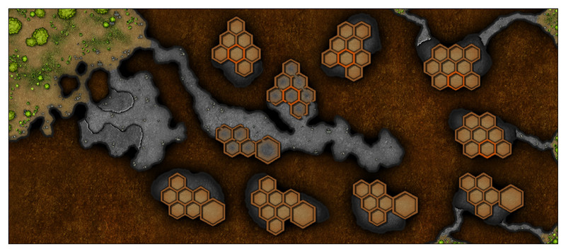
Community Atlas: Map for the Duin Elisyr area, Doriant
As the perceptive among you will have noticed, I made a further change to the locations of some of the upper level layout designs after hiding the bitmap sheet I'd been tracing, something that I find happens all the time, when things don't look quite right. And which are liable to be changed repeatedly thereafter till I'm happy (or happier...) with them!
However, to today's update. The exterior is done for now, with ground cover, some vegetation and a few tumbled smaller rocks. I've also added the new SCREEN Sheet mask to hide what's beyond the map border:
The effects on the various external ground and symbols sheets has needed a degree of amending as well to reach this point, and I've also added those three free-standing boulders/rock pillars at the mouth of the southern front cavern. Haven't done anything inside the caves as yet, although I have had to add a small polygon of one of the patchy grey dirt terrain bitmap fills (one of the "T" types) to better disguise one of the outer-inner transitional passageway ends, where (as sometimes happens), the Edge Fade, Inner effect was giving too sharp a line where the outside brown dirt bitmap fill met the grey of the cave floor.
Next will be the initial interior cavern features.
-
The Creepy Crypt project
The broken-open eggs could use a more ragged broken edge. They look much too neat presently. And again, sorry Sue!
-
WIP: ICS Immaculate Radiance
Been a very long time since I did any spacecraft designs. General principles still apply though, remembering this is a self-contained, self-reliant unit, so essentially you need everything you'd have on a normal ship with a sizeable crew - they need to eat, sleep, stay clean (clothes and person; toilets as well), exercise, medical facilities, a means of controlling each system on the vessel, a means of communicating with other vessels and shore/planetary/orbital bases, a means of carrying out the vessel's primary and subsidiary functions, emergency escape facilities, emergency handling facilities (e.g. fire, flood, general damage control), a means of observing whatever is around them outside the vessel, and as you obviously already have, propulsive engines and fuel sources. This list is not exhaustive! And almost all this has to fit within the outer hull somehow.
Spherical and rounded hull shapes are a nightmare to design for. About 40 years ago, I drew out by hand a spherical free-moving spacecraft intended as a planetary defence vessel, one of a fleet, and that was horrendous, as (well, if you're me anyway) I had to keep checking how the outer circumference affected the internal space for different parts of every vertical level, and having to keep changing things because they'd no longer fit at the size intended, and so forth.
Unless there are strong reasons not to do so that make sense in-game, there's no physical necessity from our reality to have streamlined forms for spacecraft at all. Doesn't look so "Hollywood movie pretty", I grant you, but...
-
Ferraris Style; Ramparts Not Working
I can actually see the pitted texture possibly being useful, but not here.
Unfortunately, as Sue mentioned, the appearance of the acne-pitted texture changes as you zoom in or out to the map, and you may find too that it appears different again when you prepare an exported image (resolution-dependent). This makes it difficult to rely on this appearance when drawing maps.

-
WIP Ruins of Charn
One alternative you might try would be not using the RGB Matrix effect, but setting up a simple rectangular polygon that covers all the map on its own, new, sheet, setting the polygon to have a solid red colour, and then adding a Transparency effect to that sheet. If you move the sheet to be below the text, but above the rest of the map sheets, that might work. You'll probably need to keep adjusting the Transparency, and probably also the colour of the polygon (likely somewhere in the reds and oranges range) to get to something you're happy with. Not guaranteed to work ideally, but it should give you more control over the final colour of your text, at least.

