


Wyvern
Wyvern
About
- Username
- Wyvern
- Joined
- Visits
- 3,267
- Last Active
- Roles
- Member
- Points
- 5,585
- Rank
- Cartographer
- Badges
- 24
Latest Images


-
Live Mapping: Hilltop Fort 1
Must admit, I was getting slight déjà vu feelings watching Ralf's livestream yesterday, as parts of it reminded me of my Wyvern Citadel maps for the Community Atlas. Very different scale of course, but there are inevitable similarities for drawing anything set on a craggy hilltop in this kind of more realistic style.
I made much more use of symbols however, rather than drawn polygons, for the cliffsides, though I did experiment that way originally (see this post in my Forum notes on the Citadel map, while still in progress). Just couldn't get the bevelled polygons to look right though, so switched to a technique developed for battlemat cliffs by another of our resident mapping experts, Shessar, as described via the Forum post here. As ever with CC3 mapping, there are always different methods to try!
Looking forward to Part 2 of this video, to see how it all develops. Anyone would think Ralf was running a game set in Middle Earth...😉


-
The Creepy Crypt project
Dee-licious! 🍳

-
Panzer sample thread
So far as I recall from modelling the 8- and 6-rad armoured cars (i.e. also from period images and information), the aerials were fixed in position, and at a height above the turrets all the time. These are the early-war "bedstead" frame aerial types, not the later war smaller "star antennae" which were retrofitted to some models, incidentally.
Oh - and belated congratulations on your ascension to Master Mapper status @Lillhans ! Very well done!


-
Cartographer's Annual - all the issues linked in one place
This really is invaluable, Sue. As I've printed-off the PDF mapping guides for virtually all the Annuals, I tend to remember if I've seen a given style somewhere, but if someone then asks, I end up hunting through the PF website pages to find it, usually guessing which year it's in first, because I can't find it in the mass of printouts otherwise...
I've not explored anything like enough of the issues in detail to have favourites, though my ongoing Community Atlas mapping has provided opportunities to experiment with quite a few.
@jmabbott If you're subscribed to the PF Newsletters, you'll find there are sometimes money-off vouchers available for webstore purchases in those, and the company has in the past run generous Black Friday promotions, which might make the complete Annual collection a bit less fearsomely-priced. It's how I completed my set a few years back; after that, it's "just" a question of keeping-up with it year by year. That's not so bad either, as if you're a subscriber, you usually get a time-limited, money-off renewal purchase option around the end of the current year as well.

-
Live Mapping: New City Style (Part 1)
I actually rather liked the look of the original map; there's a clarity to it that sometimes gets lost with the fancier non-vector styles. I may have made similar comments before though 😉😁!

-
Hotspot not working
Glad we got that sorted at least! I did know about the hotspot disabling, but wasn't online after you replied yesterday. Thankfully, we always have Monsen 😁!

-
Community Atlas: Embra - Enclosed Places
Enclosed Place of Interest 3 is the Floating Dale Park:
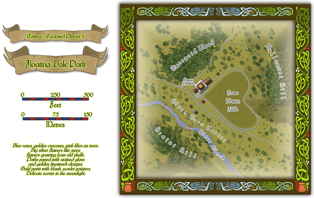
This can be used as a typical real-world park, with opportunities to wander around, or play outdoor games on the central Playing Fields, whose unusual shape may call to mind that Faerie outdoor games and sports may not be quite those familiar from the Mortal Realm.
There are a handful of surface-level buildings scattered around the map's centre, as one of the map toggles will reveal:

These include the Pavilion, where equipment for playing sports and games is available, as well as a restaurant in the central octagon beneath the building's dome. And yes, some of the vegetation is actually intended to be of living glass in Glass Tree Forest. And again yes, those ARE bridges made from rainbows over the River Clack. As ever, the text and PDF files will explain a little more about both facets, and others, from this map. In case this seems not very "Enclosed", there ARE boundaries to the Park which are deliberately less obvious than some.
![[Deleted User]](https://secure.gravatar.com/avatar/c75d9a245b74d9c59be0999ea81ca541/?default=https%3A%2F%2Fvanillicon.com%2F92add7f8c954488718110edc4896ad39_200.png&rating=g&size=200)
-
Sinister Sewers - Style Development Thread (CA207)
If the gelatinous cube symbol is actually partly transparent anyway (given you can see the texture of the floor below it), items don't all need adding to the cube. As long as the items exist as symbols, they can simply be put "below" the cube by the map's creator.
On the size element, the "you can drive a cart along them" argument is partly why I suggested seeing the sewers in "The Third Man" movie, because that's where the climactic chase happens, with large numbers of police and soldiers, where there are multiple levels stacked over one another, and nobody has any problems for headroom, and places are up to river-cavern wide in parts. Somewhat like the early London Underground "tubes" (and I'd assume others built around the same time, later 19th century), some of these would have been dug out as trenches, had their surfaces coated with mud/bricks/concrete, etc., and then covered over later where necessary.

-
SVG exports?
Fractal Terrains can export as an SVG, apparently, BUT it's not available as standard, and it may not work properly. There's a trick to it, and caveats - see this Forum post by a certain J Slayton from 2022. Your safer bet though might be using an online converter from one or other of the CC3+ "Save as..." options instead, as Scott mentioned already.

-
Community Atlas: Embra - Hilly Places
Thanks very much Sue!
I wanted the cliffs here to look different to yours, which I'd already decided to use for the red sandstone types at Embra, as the Palace Heights ones are meant to be a harder, volcanic type of rock. Actually, a Faerie type of volcanic rock, which has different properties and abilities to "ordinary" volcanic rock, so I also wanted the forms here to act as a reminder that something a little different to normal was involved. I also used a similar style of cliff drawing in one of the Crossing Places Streets - the Rocky Vale under Seafield Road there, again because the Vale is a weird place that can't be reached, another reminder of something odd happening there.
