


Wyvern
Wyvern
About
- Username
- Wyvern
- Joined
- Visits
- 3,230
- Last Active
- Roles
- Member
- Points
- 5,507
- Rank
- Cartographer
- Badges
- 24
Latest Images


-
[WIP] Community Atlas: Snakeden Swamp, Lizard Isle, Alarius - Dedicated to JimP
So finally, these maps have now been sent of to Remy for inclusion in the Atlas. Nothing much to add to what was last mentioned here about them, although for those interested, the three PDF files of notes for the set are here:


-
Mr Tumnus’ cave
And congratulations too on having your "Horse & His Boy" map selected by Ralf as one of February's Maps of the Month on the ProFantasy blog!
-
Community Atlas: Dendorlig Hall - A Sort-Of D23 Dungeon for Nibirum
Thanks for all the comments, "likes", and so forth folks! Much appreciated.
"Dendorlig Hall" it is then (and topic title amended to reflect the fact)! Please reserve it for me in the Atlas @Monsen, if not already!
@roflo1 - Yours is another fun dungeon generator, and one that for some obscure reason hadn't come up among my Google searches previously. Looking through the list you have there (for random dungeons only), I note several links are broken now, and one of the sites that still exists, Dizzy Dragon's, isn't an "https" site, which sometimes get flagged or blocked by certain browsers/browser settings now. Might be worth reviewing and amending the whole page now?
No thanks, Julian! I prefer to set my own challenges! But this might be an interesting project for another mapper here?
@Loopysue - Maybe just one of the smaller twelve-room dungeons might be a possibility for you though? Might even fit to your creation schedule if there's a fresh dungeon style coming up later this year that will need a sample map preparing, say...
Thanks for the comment re Scott's "Darklands" map too, Remy. I've been checking over the maps and descriptions for the Malajuri area since I last noted anything here, and as you wrote, couldn't find anything suggesting direct links to the surface world, though there is a somewhat "compartmentalised" layout to my blue dungeon map already, which could suggest a possible faction or two from the Darklands might have established an outpost or two here. I'll have to think about this further!


-
The Creepy Crypt project
Dee-licious! 🍳

-
Panzer sample thread
So far as I recall from modelling the 8- and 6-rad armoured cars (i.e. also from period images and information), the aerials were fixed in position, and at a height above the turrets all the time. These are the early-war "bedstead" frame aerial types, not the later war smaller "star antennae" which were retrofitted to some models, incidentally.
Oh - and belated congratulations on your ascension to Master Mapper status @Lillhans ! Very well done!


-
Live Mapping: Hilltop Fort 1
Must admit, I was getting slight déjà vu feelings watching Ralf's livestream yesterday, as parts of it reminded me of my Wyvern Citadel maps for the Community Atlas. Very different scale of course, but there are inevitable similarities for drawing anything set on a craggy hilltop in this kind of more realistic style.
I made much more use of symbols however, rather than drawn polygons, for the cliffsides, though I did experiment that way originally (see this post in my Forum notes on the Citadel map, while still in progress). Just couldn't get the bevelled polygons to look right though, so switched to a technique developed for battlemat cliffs by another of our resident mapping experts, Shessar, as described via the Forum post here. As ever with CC3 mapping, there are always different methods to try!
Looking forward to Part 2 of this video, to see how it all develops. Anyone would think Ralf was running a game set in Middle Earth...😉
-
Community Atlas: Embra - Enclosed Places
Enclosed Place of Interest 3 is the Floating Dale Park:
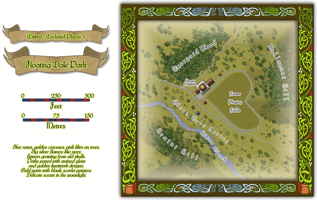
This can be used as a typical real-world park, with opportunities to wander around, or play outdoor games on the central Playing Fields, whose unusual shape may call to mind that Faerie outdoor games and sports may not be quite those familiar from the Mortal Realm.
There are a handful of surface-level buildings scattered around the map's centre, as one of the map toggles will reveal:

These include the Pavilion, where equipment for playing sports and games is available, as well as a restaurant in the central octagon beneath the building's dome. And yes, some of the vegetation is actually intended to be of living glass in Glass Tree Forest. And again yes, those ARE bridges made from rainbows over the River Clack. As ever, the text and PDF files will explain a little more about both facets, and others, from this map. In case this seems not very "Enclosed", there ARE boundaries to the Park which are deliberately less obvious than some.
![[Deleted User]](https://secure.gravatar.com/avatar/c75d9a245b74d9c59be0999ea81ca541/?default=https%3A%2F%2Fvanillicon.com%2F92add7f8c954488718110edc4896ad39_200.png&rating=g&size=200)
-
Community Atlas: Kara's Vale, Ethra, Doriant
Back to the remaining half-dozen Tower levels with Level Seven:
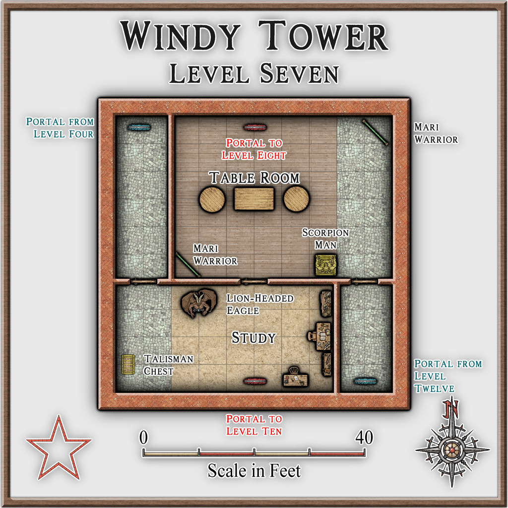
This is the level the magical, golden talisman is on, which is required to activate the portal to access Level Thirteen (coming-up on Level Nine below), and either it or the amulet from Level Two may be needed to regain access to the Tower, if left at any stage. I decided to only wall-off parts of the two outlying cobblestone-floor sections here (derived from the original floorplan), because that helped make this level feel a bit more weird.
Lots of leonine critters in ancient Mesopotamia! The Lion-Headed Eagle though is something special, as it was either a demi-god, or a full-fledged deity (possibly at a period antedating the early 3rd millennium BCE) called Imdugud (later Anzu), which had the form of a giant eagle with heavy claws, a lion's head, and, from at least one myth-text, shining, multicoloured feathers and magical powers.
The Scorpion-Man is a bow or spear-armed humanoid with a human torso, arms and head, set on a chitinous giant scorpion's lower body, legs and stinging tail.
Level Eight:
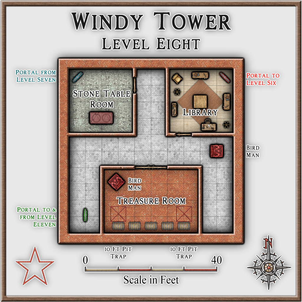
A fairly straightforward level here for once, except for a couple of floor pit traps in front of two of the treasure chests.
Level Nine:
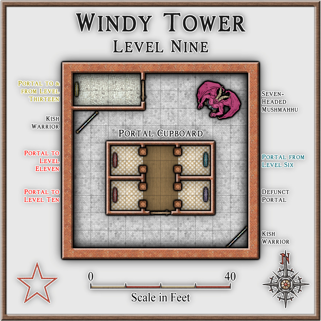
Here we find the portal that goes to Level Thirteen, which of course is the dungeon map that started this set of maps off. That's dealt with by a separate map in the Atlas now, however. Plus for variety, we also have a non-functioning portal.
The Seven-Headed Mushmahhu probably needs an explanation. It's an imposing, hydra-sized creature with a huge lion's body, and seven, writhing, giant serpent necks and heads. Known from several variant artworks from the early 3rd millennium BCE, sometimes such a creature has a purely serpentine body as well, and in either form, one or more - though not all - its heads may be shown as dead. In its lion-bodied form, it has rays rising from its back, which might be magical defences, or simply fire/heat, which rays seem to form one of its own powers. Sometimes shown with one or two deities in combat with it too. It's basically the top predator in the Tower.
-
Live Mapping: Character Artist 3
Just finished catching-up with today's video, as I wasn't able to be there for it live.
I've used Character Artist quite a bit over the years, and it was a shame to discover there are no plans to update or expand it, if perhaps understandably so, given it is something of a "luxury" add-on, compared with the primary mapping purpose of CC3+ in general.
Reviewing the video so soon after it was posted means the chat wasn't available to view (it sometimes is lost anyway, if the video is later edited before its final YouTube posting), but I don't think it was mentioned there that there is also the original Character Artist Pro, which has many more drawn-symbol options than CA3, and is much easier to draw your own additions onto, because it uses the far simpler vector drawing style. I suspect many now wouldn't feel it to be "pretty" enough, compared to the more modern hand-drawn version, unfortunately, but it is a versatile tool that shouldn't be ignored - to me, at least!
-
[WIP] - An audience with the King
You're just throne this out there, aren't you? 😉

