


Wyvern
Wyvern
About
- Username
- Wyvern
- Joined
- Visits
- 3,266
- Last Active
- Roles
- Member
- Points
- 5,585
- Rank
- Cartographer
- Badges
- 24
Latest Images


-
Good sizes for fantasy cities etc
As Jim said, there's going to be a lot of personal preference involved here, heavily dependent on how you see your world setting developing, what types of civilizations exist in different places there, as well as how much time and effort you have available for designing and mapping it all.
Plus you're really asking two different, if related, questions - 1) the number of key buildings desirable for different types of settlement, and 2) what the appropriate size of different types of settlement can be for different types and numbers of special buildings.
The question of settlement sizes has come up on the Forum here before, and you might like to look over the comments on these two topics, both of which coincidentally came-up in late 2018:
Looking for advice on starting Village/Town/City size
There are also various systems for designing RPG settlements available online, some paid for (on sites such as DriveThru RPG), some not (such as blogs), as well as a number of random design systems, such as those on the Watabou site, although those provide primarily maps, rather than lists of the specific places you indicated as of interest.
Those should get you started at least, or perhaps help clarify what it is you want (or even don't want!) from such systems, from where you might feel more confident about creating your own settlement design system.
Good luck!


-
[WIP] Community Atlas, 1,000 Maps Contest: Villages in The Whispering Wastes of Haddmark, Peredur
Map six - Hex 1304, Arvika:
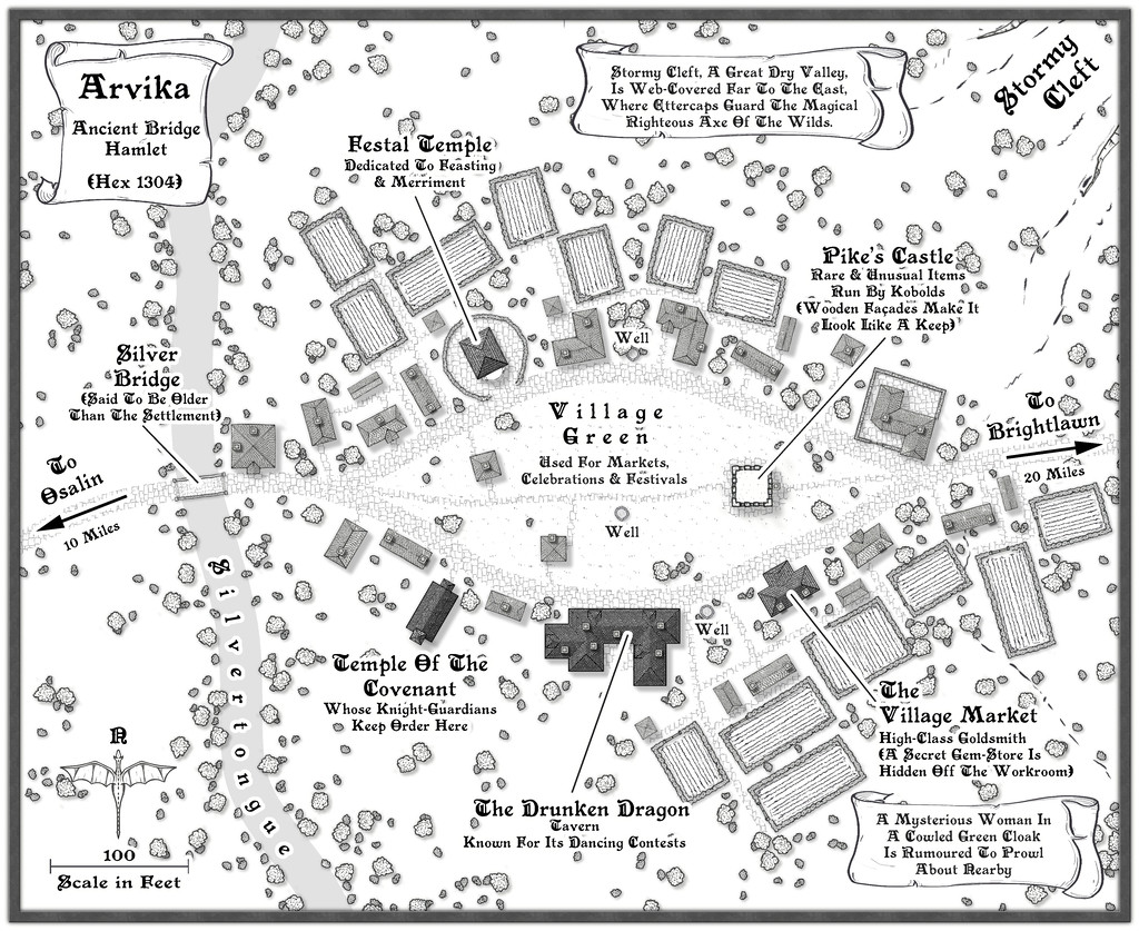
Arvika was one of the three settlements in this area that were originally shown on the existing Atlas map. In the absence of any text notes for it there, I simply looked at what the symbol was - a hamlet. As luck had it, no random feature was selected during the creation of my Whispering Wastes regional map for the hex it was in, but there was something in an immediately adjoining one, a mysterious ravine partly filled with webs, where a legendary artifact was guarded by a nest of Ettercaps. So I simply moved the ravine into the hamlet's hex, combining both elements. The hexes are six miles across, north-south, after all, so there's room for a lot more than just a single feature in each one.
The setting for the place was to be in a river valley, the Silvertongue, and I randomly discovered instead of the fords, so popular elsewhere so far, the proximity to the uplands had clearly provided stone enough for a bridge here for once, and it also turned out to be notably ancient, something that, like the Stormy Cleft ravine, simply helped reinforce why this hamlet had ended up being shown on the Atlas's area map, while other, seemingly larger or similarly-sized, settlements in the Whispering Wastes had not appeared there. Mapping it was straightforward enough, with the contour symbols fitted-in to act as the entrance to the ravine, although I did add a few more fields than I'd initially thought to provide some further interest around the settlement itself, which also lessened the impact of the ravine on the whole drawing.


-
Is there a reference that gives the latitude and longitude for locations on Toril?
Monsen's right in that virtually everything that tries to equate the Forgotten Realms setting to anything genuinely geographic has been done by the fans only. Part of the problem is that the size of some of the continents were changed at different times, and as the setting developed through various novels written by different people at different times, there was never a single basis on which any of this was hung. It's extremely irritating!
Even the official TSR 1990 "Forgotten Realms Atlas" by the great Karen Wynn Fonstad shows nothing of any latitude and longitude lines, though she does demonstrate very clearly in that just how little of the planet had been even approximately mapped by that time.
The only thing I have come across is a mention on the Candlekeep.com site in their FAQs regarding a map in "Faiths & Avatars" (TSR, 1996) regarding where the equator is. I found that via this discussion post on the Forgotten Realms Wiki site, which mentions the same map shows the canonical lines of lat and long, though so far as I can tell, while there are some lines shown, none have labels attached.

-
Style Request: East Asian Floorplan/Dungeon
Isometric building and room maps can look good for players, but they're often a nightmare for GMs trying to run an adventure, where you need to know exactly where everything in a room is at a glance, and how it connects to everything else in its vicinity. A top-down map gives you that control, plus for players, they can see instantly where everything is too, as battlemaps, for instance.
Iso can have its uses for a GM though, where flat wall features (such as carvings) might be important, say, though that may need several views so all walls can be identified and seen clearly.
Slightly concerned that "East Asian" seems to be being redefined as just meaning "Japan" here, given Japan's a tiny fraction of East Asia overall. Might be better to retitle this topic as referring to Japan only? Or expand the discussion to include features from China, Mongolia, the Koreas, Taiwan and perhaps places adjacent as well?

-
The Creepy Crypt project
Yet still no cat... 😁🐈️

-
Community Atlas: Queen Mica's Scintillant Palace
Thanks very much Remy!
Slightly shocked on doing a quick tally-up today, while downloading the latest Atlas version, to discover this makes 140 maps of mine now in the Atlas! I'd forgotten quite a chunk of the earlier materials I'd done, looking at the list.
Still some way behind the great leaders of Quenten and JimP of course, but not doing too badly by comparison 😊
Plus, I think once the contributions from the recent mapping contest are added, this could take us over 850 maps in all!

-
Live Mapping: Herwin Wielink Overland
I've done a lot of mapping with this style (and indeed I currently am again), largely because I like it so much. I picked it as the basis for the 40 maps in my ongoing Errynor mapping project for the Community Atlas, after all! It'll be nice to see it get some live-streaming love and attention though!
I find it actually has quite a good range of symbols, more so than some styles, which, in combination with the range of textured fill options and colours, is what makes it so attractive for me.
Of course all styles could always do with more symbols - as many of us have commented here before 😁
[And I think we all also know in most cases, that's not going to happen!]

-
Sticky Note Dungeon
And now the Sticky Dungeon has been released into the wild, as the October 2024 Cartographer's Annual issue!
Many congratulations to C.C. for this fantastic achievement!
-
The Creepy Crypt project
Dee-licious! 🍳
-
Panzer sample thread
So far as I recall from modelling the 8- and 6-rad armoured cars (i.e. also from period images and information), the aerials were fixed in position, and at a height above the turrets all the time. These are the early-war "bedstead" frame aerial types, not the later war smaller "star antennae" which were retrofitted to some models, incidentally.
Oh - and belated congratulations on your ascension to Master Mapper status @Lillhans ! Very well done!


