


Wyvern
Wyvern
About
- Username
- Wyvern
- Joined
- Visits
- 3,266
- Last Active
- Roles
- Member
- Points
- 5,585
- Rank
- Cartographer
- Badges
- 24
Latest Images


-
The Writer's Map
Dragging this topic back into the light, as I recently discovered this book was reprinted in all its glory in 2024 (the original is dated 2018). It's an astonishing, and beautifully-illustrated, collection of essays by various authors. It's been on the shelves in my local bookshop since at least December apparently, though I only saw it in detail for the first time today.


-
Community Atlas: Embra - Hilly Places
Miller Hill as Place 4 seemed an obvious choice for a Hilly site. However, as stated already, y'know, Embra. So this is a water mill at the top of a hill, with a stream that runs uphill to the mill pond on the summit, runs the water wheel, and then descends down the other side of the hill again! Naturally, no one here thinks this is anything unusual - how could the mill run without a water source, is the primary response to those who might seek to question the setting:
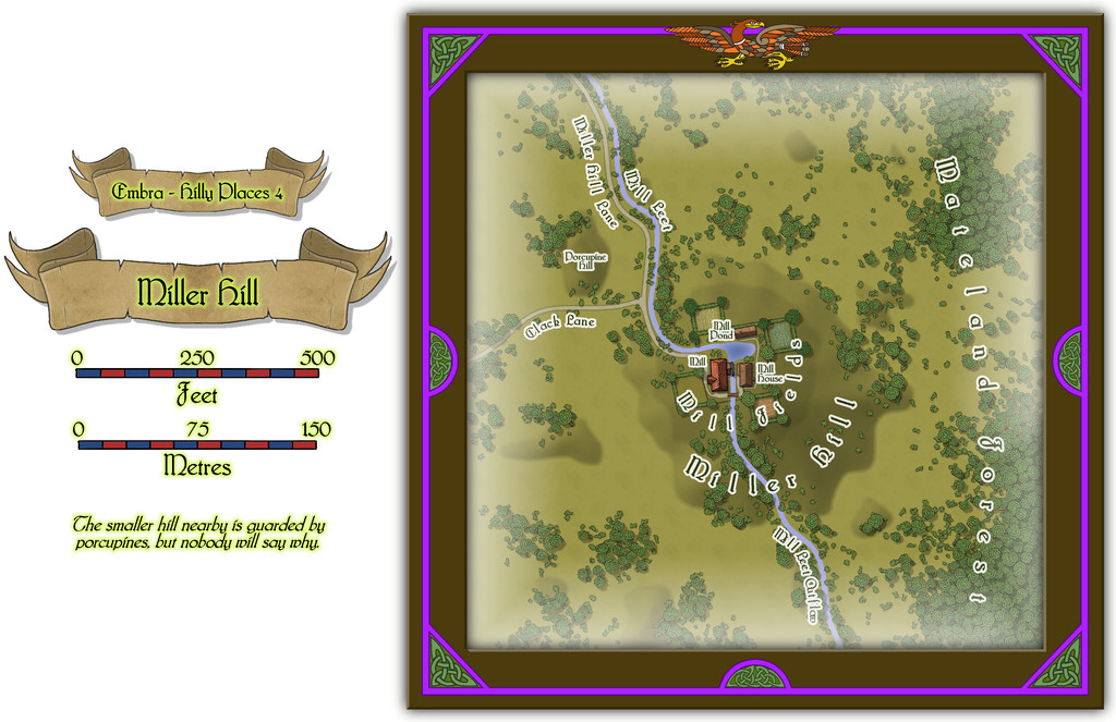
There are some buildings on this map too, for once in the "Hilly" selection, which have interiors that can be viewed using the toggle in the FCW file in the Atlas, all being well:
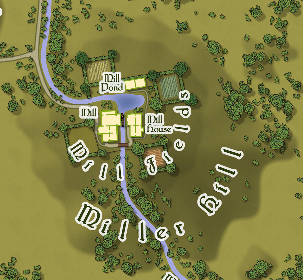
It has to be said I was delighted to see the random base map options had provided one that so obviously fitted the nature of a mill site of this, shall we say unusual, kind - those four square fields looking like the sails on a windmill. So there's a note in the PDF and text files for this map suggesting GMs could have the four fields, and their hedge/fence lines, rotate, flowing over the land surface like cloth, carrying anyone in one of the fields along with them, but only when the wind blows strongly. Everything else of course stands quite still; and not entirely by chance, the rotation centres more or less on the axle of the mill-wheel, where else?
![[Deleted User]](https://secure.gravatar.com/avatar/c75d9a245b74d9c59be0999ea81ca541/?default=https%3A%2F%2Fvanillicon.com%2F92add7f8c954488718110edc4896ad39_200.png&rating=g&size=200)

-
My first completed map utilizing CC3+
Not really seeing too much looking "wrong" with your map, to be honest.
As with most styles, there will be things that seem to work better than others sometimes, and it's often just a question of knowing what options there are, and what (sometimes quite small) tweaks will help make things look closer to what you were hoping for. Sue already covered your points regarding forests, settlement placement, and terrain fill blending, I think.
For your point 3, symbol scaling, sometimes the "correct" symbol scaling just doesn't look right - or maybe not for all the available symbols - so you simply have to rescale the ones that don't look so good to fit more with how you envisaged them looking at the scale of the whole map (not zoomed-in though!).
Point 5, unknown areas. You could add areas of a standard terrain fill with no symbols or other features, and maybe add a new Sheet with a pale single-colour polygon - like a grey or white - drawn over the unknown region, and add a Transparency Effect to that, perhaps with an Edge Fade as well. Or you could try a Blur Effect on the terrain fill itself - again set it on its own Sheet so it's not ALL the terrain that does this! Blur can make the file uncomfortably large if used too frequently, however. Just trying things out with the Sheet Effects is always worth doing, so you get a better feeling for what they can do. If there are terrain features that must be in the region too, you can also partly hide them this way. It really depends what you want the area to have the players might know about in advance.
-
Where to Find Additional Assets?
Try typing general keywords into the DriveThru search-bar - such as "mapping icons" or "map symbols". If you try to make the terms too specific, the search facility tends to get quite restrictive, so unless you know the name of a specific product you're trying to find, it's probably best to avoid them.


-
Cosmographer and Moon Orbits
This is a pretty complex set of tasks you're hoping to accomplish here, but as long as you're happy to put in the work yourself, it should be perfectly possible. That may depend on how comfortable you are working with the mathematics of orbital mechanics, however, and exactly what degree of precision you're hoping to achieve.
I'm not aware of any tools that will allow you to do all of this in one, but you may find some of the tools linked from the Worldbuilding Links and Software page of the Orion's Arm Universe Project website helpful. Note that some of these are only available via the Wayback Machine archival website now, and may use older software types to function. I've not really done much with this in a long time, so can only hope some of it may assist!
Unfortunately, the few folks I know, or knew, who did this kind of thing tended to write their own programs to do it, and while that may be an option for you too, that's not something I've had any experience with, sadly.
Good luck anyway!

-
Expansion to Ellis Prybylski Watercolor Style
Yes please to the Elf, Dwarf, Halfling and Orc structures, plus ruins, ships, icy elements, a volcano-mountain, variant settlement features (including for different cultures)! And after those, also perhaps:
- Magical site markers
- Battlefield marker, and a more general flag-style marker, to highlight important sites that don't fit to specific structure types.
- Oasis symbols for the deserts.
- Two more bridges at different angles to the current one - one running straight down the page, the other angled down from top left to lower right.
- I really like the Henge and Tomb hill markers, as they look good on any terrain. Another such marker with a cave mouth would be very useful.
- Some Mountain Peak symbols without the snowy tops (so grey mountains, just no white caps).
- Seeing the animal and creature comments, just the actual creature without any associated terrain would be better, as usable anywhere. Snag is, going down this route is liable to lead to requests for a lot more "resources" style markers - domesticated creatures and crops, minerals, etc.
- Some jungle-style trees, perhaps including mangroves, as well as the fruit trees Monsen mentioned.
I'll probably think of others later, but these are what're coming to mind right away. It's a wonderful style, and it would be excellent to see it expanded as far as possible in future, I think.
And thank you very much for creating it!


-
Hexcrawling starter maps
There's an obvious couple of problems here. One is there isn't a great enough diversity of symbols to cover even the fairly small range of non-settlement features that might be useful, and which only an expansion of the style (either by PF or personally) would solve. [There is a further issue here too, in that none of the location symbols actually work to the standard snap grids used in this Annual. I'm not sure if that may have been amended since I downloaded my copy, however. I ended up having to place most by eye alone, certainly.]
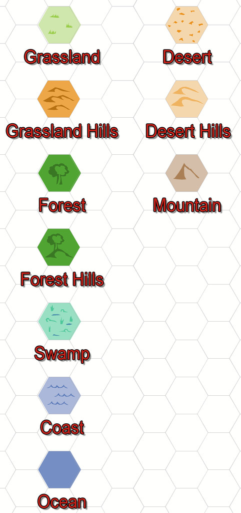
The other is that anything placed in a coastal hex looks as if it's really in the sea, because that's just how hex maps of this sort work. That though is something I could resolve. Plus as I'd been randomly rolling terrain up, I'd noticed there was no "Hills" option in the current ShadowDark tables, so decided to tweak that a little to include some.
So the maps, and additional keyed terrains, came to look like this:
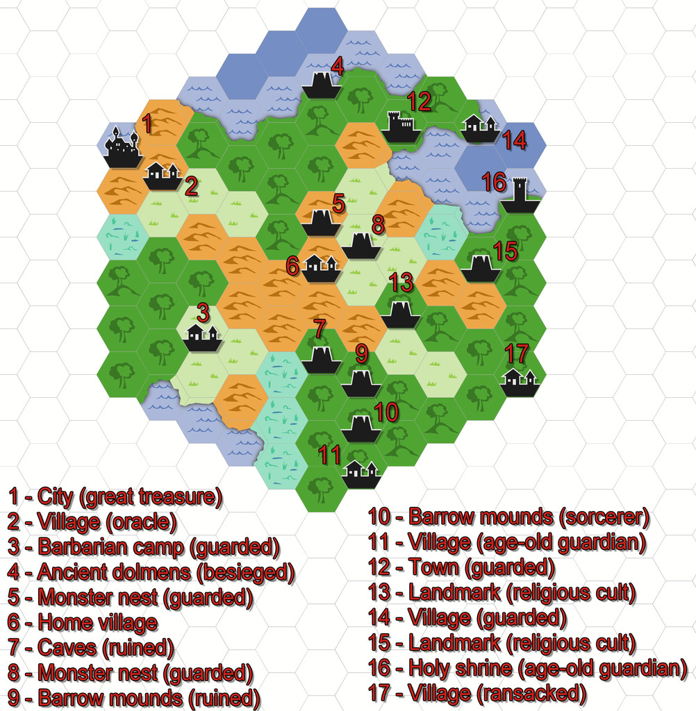
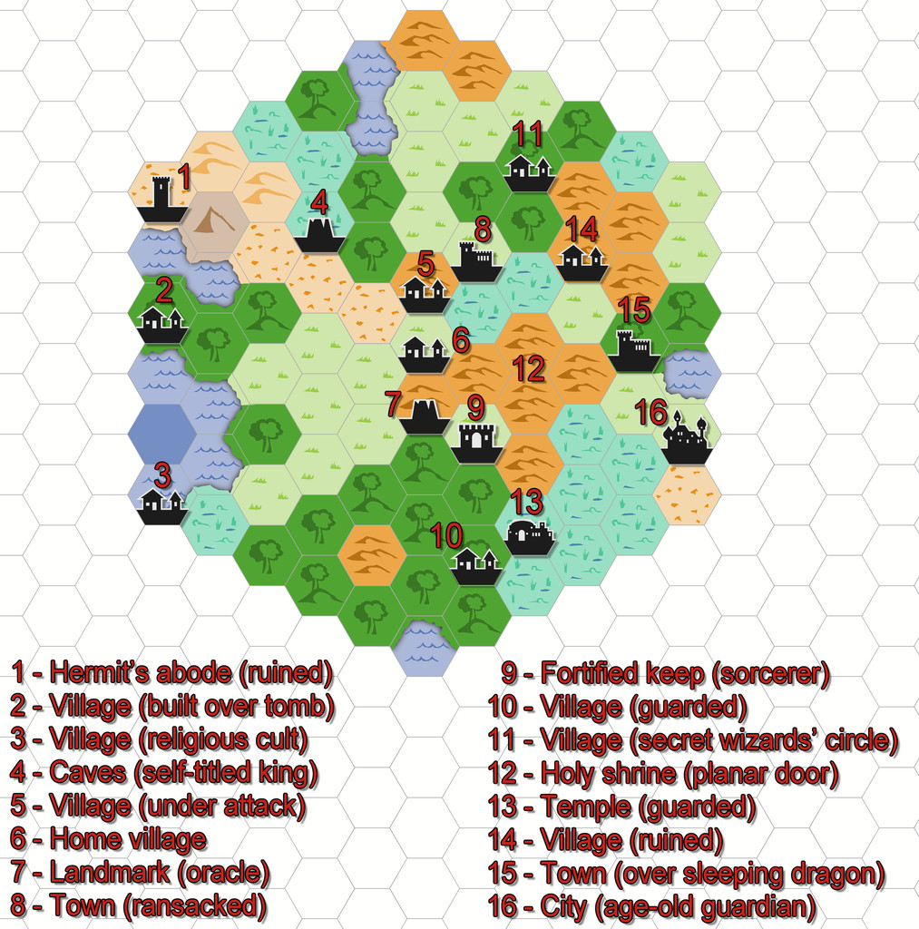
All I did for the coasts was add a small section of land from each adjacent hex over the coastal sea.

-
What games do you use ProFantasy to create maps for?
D&D, homebrew RPG systems, Ars Magica, Call of Cthulhu, Erin (fantasy Irish-myth-based wargames), Laserburn (science-fiction skirmish wargames) and Hordes of the Things (fantasy tabletop wargames), in terms of specific game systems, though a lot of what I've used CC3 and CC3+ for has been to provide maps to illustrate published ancient military history factual articles. I have a lot of hand-drawn maps from other RPG systems going way back too which might be fun to convert into CC maps at some stage. However, the Community Atlas mapping takes up most of my mapping efforts presently!

-
Issue 199
Yeah, nothing with computers is ever easy, is it, Jim? 😏
@Mike Vermilye - I've just done a very quick test new map with my own reinstallation, and am not seeing the problems you've mentioned. However, I didn't do an uninstall, I just deleted the files and folders that Ralf referred to:
Once I'd done that, I simply installed the replacement Monkey Frog Annual as new.
I'd suggest going through the three places in Ralf's list, removing both any surviving Silverman AND the Monkey Frog versions, and then try a fresh installation of the new Monkey Frog version of the Annual, to see if that resolves things. Failing that, you'd probably be best advised to contact ProFantasy support (through your account page) - unless someone else leaps in here with an alternative. I am NO expert with computers, so that might be your better option now!
-
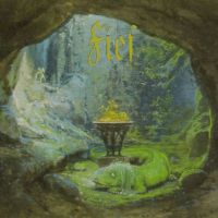
Mythic Carpathia map by Free League Games
There's a good reason for that. It is!

