


Wyvern
Wyvern
About
- Username
- Wyvern
- Joined
- Visits
- 3,266
- Last Active
- Roles
- Member
- Points
- 5,585
- Rank
- Cartographer
- Badges
- 24
Latest Images


-
Community Atlas: Embra - Watery Places
Stepping things up a little, for all the map is still a reduced-size one, Watery Place two is Bright-Eye Well:
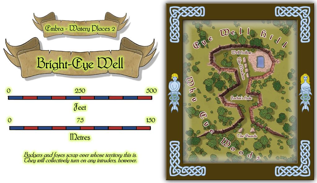
Coming up with a magical well is a bit "shooting fish in a barrel" for RPG scenario-writers, but using details from the original base-map (which was actually for a subterranean barrow tomb) meant I could add some extra interest here, along with making it an open-air feature, a partly natural, partly quarried, hollow in the edge of a hillside. Not quite sure what it is about red and pink rocks that have held a long fascination for me, but I made an early decision that one of the main rock types that was going to keep recurring at Embra was red sandstone. And as luck had it, the second of @Loopysue's excellent sets of City Cliffs symbols comes with a set of red sandstone symbols and fills! So that was an easy choice.
There's a knack to using connecting symbols effectively. Sometimes that means turning-off their ability to connect, and placing them individually. Sometimes you can just let them "have their head" as it were, and make whatever pattern they will. Usually, that latter works fine for straight, gently undulating, or long curving lines. When it comes to more intricate structures, it can be better to opt for individual symbol placement. Here though, despite the strongly curving lines in a short space, I decided to try using the connecting-symbol option, and see what happened, because this area was meant to look as if it had been straight-edge carve-quarried in places. It took a couple of tries to get something close to what I wanted, and then a lot more tinkering to get the shadow effects to work OK (don't look too closely behind a couple of strategically-placed trees, that's all!).
Those familiar with northern English dialect may appreciate a couple of the more curious map labels, although the Fachin's Hole name derives from real-world folklore, as something I'd decided from soon after the shape of the base map for this drawing had been chosen. A Fachin is a Scots' Gaelic fearsome Faerie creature, with one leg, one hand that protrudes from its chest, a single eye and rough, spiky hair. Sometimes considered of giant size, its preferred lairs are lonely gorges and lakes. That overall shape seemed to fit with the cliff-line being a loose, crude profile image of such a creature, with the Well as its eye.

![[Deleted User]](https://secure.gravatar.com/avatar/c75d9a245b74d9c59be0999ea81ca541/?default=https%3A%2F%2Fvanillicon.com%2F92add7f8c954488718110edc4896ad39_200.png&rating=g&size=200)
-
Cosmographer and Moon Orbits
This is a pretty complex set of tasks you're hoping to accomplish here, but as long as you're happy to put in the work yourself, it should be perfectly possible. That may depend on how comfortable you are working with the mathematics of orbital mechanics, however, and exactly what degree of precision you're hoping to achieve.
I'm not aware of any tools that will allow you to do all of this in one, but you may find some of the tools linked from the Worldbuilding Links and Software page of the Orion's Arm Universe Project website helpful. Note that some of these are only available via the Wayback Machine archival website now, and may use older software types to function. I've not really done much with this in a long time, so can only hope some of it may assist!
Unfortunately, the few folks I know, or knew, who did this kind of thing tended to write their own programs to do it, and while that may be an option for you too, that's not something I've had any experience with, sadly.
Good luck anyway!

-
Sticky Note Dungeon
But one corner isn't curling-up where the glue hasn't stuck properly, unlike the real things 😉!

-
Panzer sample thread
Excellent! And now without the canvas roof? 😁 And then with the anti-aircraft guns mounted on the rear. And...
You know Forum folks - we ALWAYS want more symbols!


-
City locations
Might want to tweak the angle of the seating a little for the rows nearest the outer walls; otherwise, patron complaints about stiff necks can be expected!
Will there be upper levels too?
-
Dhakos, The City of Spires - Watabou Cities Annual
Well this is weird, as I've just dropped-by the Forum here following a lengthy discussion on one of my Discords with someone about the old Chaosium versions of the "Stormbringer" RPG, a few minutes ago!
Not sure if it'll help with your spires query, but I had to draw my own shadows of not dissimilar form for one of my Atlas maps a while back, the Thalassan Castle Ruins. The FCW might give you a further pointer or two, perhaps. Or perhaps not! Good luck, regardless 😁

-
Several maps for (random forest) encounters
The default sun position in CC3 is from the north west... even though the sun is only ever in that direction for real if you live in the southern hemisphere.
Not quite true, Sue, as from the northern hemisphere in summer, around June-July, the Sun sets in the northwest too. From much of Britain, that's around or indeed north of, true azimuth 315°. 😎

-
Ancient maps
That 22-foot Roman Empire map is the Peutinger Table, aka Tabula Peutingeriana, and the Wikipedia page includes a high-res complete image of the whole - may take a while to load, however, as the full-size JPG is about 15 MB. This is the direct link to that Wikimedia image.

-
Town Map for a Cthulhu Game
Interesting time to be thinking vampires/Dracula, as 2022's the centenary of the classic F W Murnau silent movie "Nosferatu", of course. Wikipedia link for movie in case anyone needs info/a reminder on this film.

-
Expansion to Ellis Prybylski Watercolor Style
Yes please to the Elf, Dwarf, Halfling and Orc structures, plus ruins, ships, icy elements, a volcano-mountain, variant settlement features (including for different cultures)! And after those, also perhaps:
- Magical site markers
- Battlefield marker, and a more general flag-style marker, to highlight important sites that don't fit to specific structure types.
- Oasis symbols for the deserts.
- Two more bridges at different angles to the current one - one running straight down the page, the other angled down from top left to lower right.
- I really like the Henge and Tomb hill markers, as they look good on any terrain. Another such marker with a cave mouth would be very useful.
- Some Mountain Peak symbols without the snowy tops (so grey mountains, just no white caps).
- Seeing the animal and creature comments, just the actual creature without any associated terrain would be better, as usable anywhere. Snag is, going down this route is liable to lead to requests for a lot more "resources" style markers - domesticated creatures and crops, minerals, etc.
- Some jungle-style trees, perhaps including mangroves, as well as the fruit trees Monsen mentioned.
I'll probably think of others later, but these are what're coming to mind right away. It's a wonderful style, and it would be excellent to see it expanded as far as possible in future, I think.
And thank you very much for creating it!


