Wyvern
Wyvern
About
- Username
- Wyvern
- Joined
- Visits
- 3,266
- Last Active
- Roles
- Member
- Points
- 5,585
- Rank
- Cartographer
- Badges
- 24
Latest Images


-
[WIP] Community Atlas, 1,000 Maps Contest: Villages in The Whispering Wastes of Haddmark, Peredur
Hex 1702, Fairbridge Village:
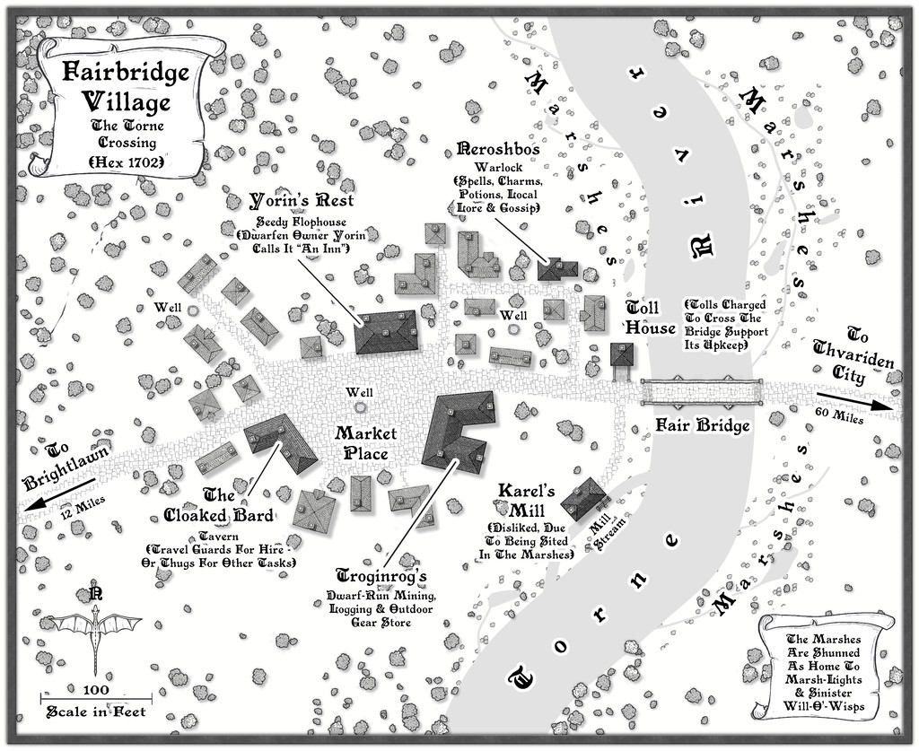
Last of the ten Whispering Wastes villages and hamlets, Fairbridge appeared on the original Haddmark regional map only as a bridge, though it was an obvious feature to add a settlement to, if only to ensure the bridge's upkeep - hence the Toll House, an addition beyond the random options the Shadowdark tables provided, as indeed was the Mill, this time with a smaller stream cut from the main river channel to be a more controllable water source. River crossing points can be tricky places, as the ground needs to be quite low-lying to provide access, which in turn can be muddy and difficult, although here, I opted to have some marshes, largely because one of the random provisions was some sort of inimical creatures, and Will-O'-Wisps came up in that process. Naturally, nobody really likes using the Mill, because it's in the marshy land too, for all it is essential.
Those marshes also decided me against adding fields nearby this time. So many travellers have to use the bridge, essential supplies of food likely aren't going to be a great problem here, albeit the place is fairly run-down too, with many folk simply passing through. It is something of a gateway to the Whispering Wastes and the settlements beyond it to the west and south, from the more heavily-populated areas east and north from here by the great Siljan Lake.
Having completed this group of maps, it has again reinforced that it can be helpful to map places in a similar region in the same style for consistency, like this small settlement ten. It also makes things easier as the maps continue - and thus quicker - thanks to familiarity with the mapping style. The first map is always slower, while getting used to things, knowing what works and what doesn't. After that, things speed-up, and it becomes easier to try mapping new elements. The marshes here were my final challenge, as there isn't a marsh symbol or fill in this style, so I reused the rescaled "Trees" fill instead, simply because it looks sufficiently different to everything else. To make sure everyone's clear though, I also added some labels and small water features.
Onward now, as mentioned a while ago, to somewhere in Feralwood Forest, Alarius, for a suitable spot to site my next small dungeon map. It's going to be wild 😉!


-
[WIP] Community Atlas, 1,000 Maps Contest: Villages in The Whispering Wastes of Haddmark, Peredur
The penultimate map in this series of ten is from Hex 1611, Skara Hamlet:
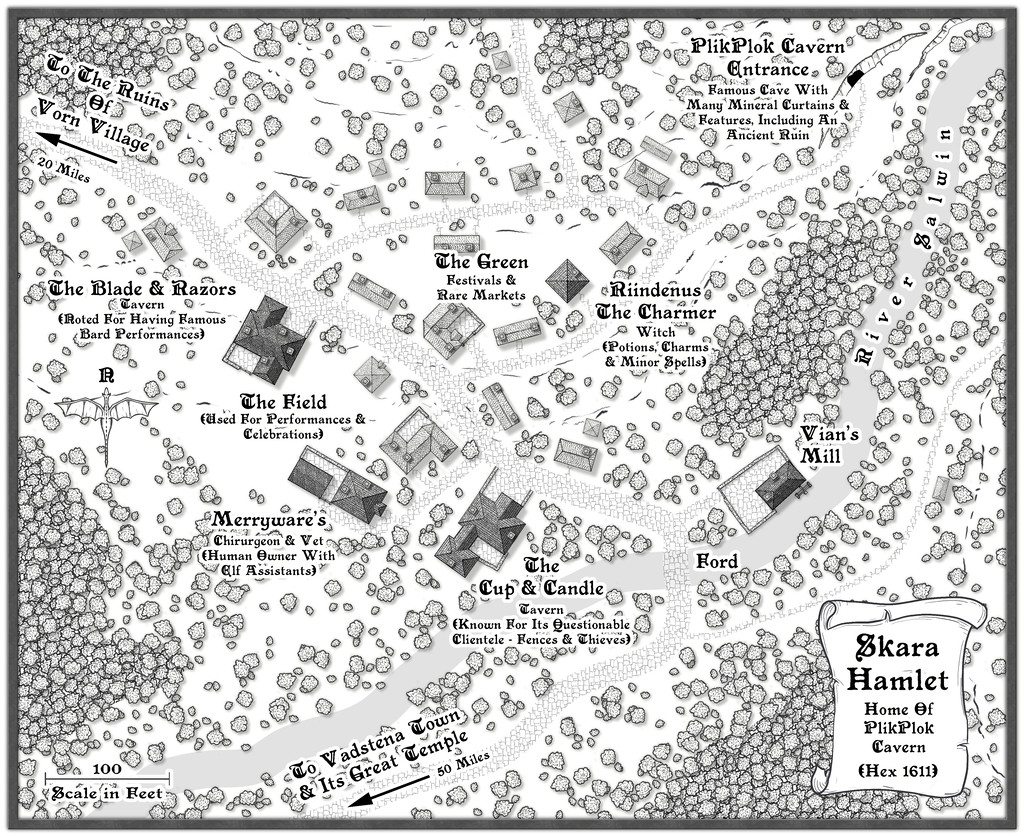
Last of the three settlements marked on the Haddmark regional map for the area that is now the Whispering Wastes, this was in another hex that missed out on being randomly selected as holding a feature of interest, so one in its immediate neighbour to the northeast was simply swapped-in, which is how we have PlikPlok Cavern as a notable element on this map, or rather the entrance to it. Beyond that, looking at the general area map, it seemed likely this settlement would form a focal point for the surrounding farming and logging districts, given the western fringes of the Skara Bray hills, in whose southwestern tip Skara is located, have denser woodlands shown on them, along with the hills themselves, and the relatively nearby major Torne River. It also felt plausible that such places would be quite scattered, so the settlement itself was allowed to spread out here too, helping make it seem more important than the number of buildings alone might suggest.
While constructing the map, and having the overall close-by region in mind, I decided to add more walled, paved yards here than in other places, since the proximity of the upland surroundings - hinted-at by use of the contour and cliff symbols - suggested a more readily-available source of building stone for Skara. In-keeping with its somewhat lowly status though, the wall-lines aren't always especially straight. Nearer the centre, The Field and The Green ended up as open spaces almost by accident, as while I wanted to add some denser woodlands around the periphery, I didn't want those to become too dominant. Plus The Blade & Razors needed an outdoor space to expand its events into, and the significance of Skara to the surrounding areas meant some kind of open space for occasional markets - even though no specific market place was randomly assigned to it - seemed a natural addition as well. As mentioned before, sometimes these things just happen almost by themselves. Meanwhile the random option for a chirurgeon was amended to become also a vet, given the significance of livestock hereabouts.
Final map now approaches!


-
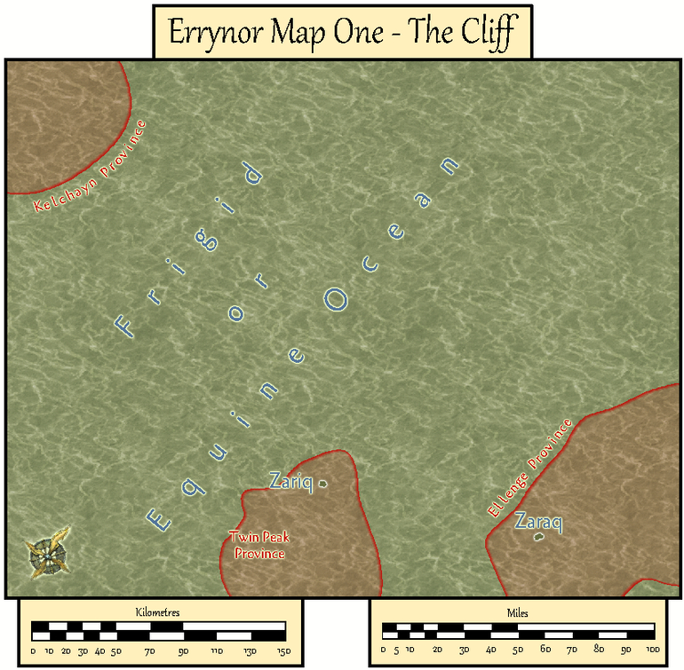
Community Atlas: Errynor Map 01 - The Cliff
With the new undersea symbols ready, finally I could begin constructing the first map. Logically, this was to be my original Map 1, at the top left corner of the Errynor map:
Clearly, the seabed was going to be the primary aspect here, with just two tiny islands above sea level, so that's where I began:
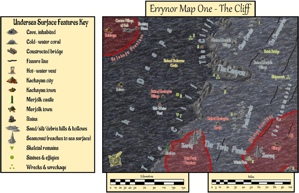
The tremendous cliff at the continental shelf edge is so dominant here, that had to become the map's name, while the relative sparsity of other undersea surface features had been a deliberate choice from the initial planning of the main Errynor map. What items are shown, are thus those more easily found by new travellers to the area, or those whose presence is more influential for whatever reason. This also reflects the apparent nature, as far as can be established, of Earth's own ocean floors. The shallowest seabed mapped here, towards the lower right corner, lies below some 300 m (nearly 1,000 ft) of seawater, for instance. It further fits with the idea of the relative smallness of the undersea intelligent populations in the region, compared with the vastness of Nibirum's oceans, as I'd envisaged them. There is the further advantage that plenty of space is available for GMs to add extra points of interest, should they wish.
The red-limned regions are Kachaya/Sea Devil provinces, incidentally.
I added a SOLAR/GEOMAGNETICS Layer overlay to show lines of latitude for each 1°, and the midline for Nibirum's polar auroral zone. This option should be available by a toggle for the Atlas version.
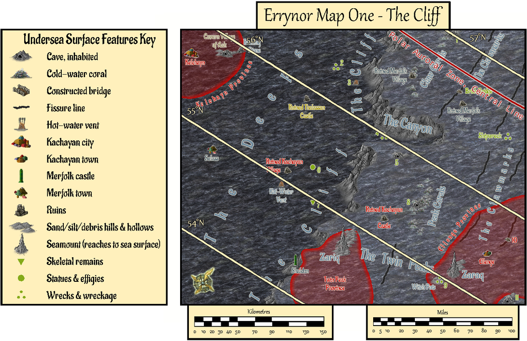
These 250 x 200 mile maps are small enough for the north direction to be fairly consistent across most of the area covered, so I'd been able to add a compass rose as well, which hadn't been possible for the main Errynor map.
When designing the hand-drawn paper maps at the start of this project, a selection of larger/more interesting/more dangerous creatures (and things, for the solid surface) that could be encountered had been randomly included. Many of the undersea types were free-swimming. For RPG use, it's naturally important to know where these are not merely for the sea and undersea land surfaces, but in the water column between too. Hence another map toggle, activating the UNDERSEA WATER COLUMN Layer, is intended to shift the view to that water column (it's best to turn off the TEXT, SURFACE UNDERSEA Sheet for clarity first):
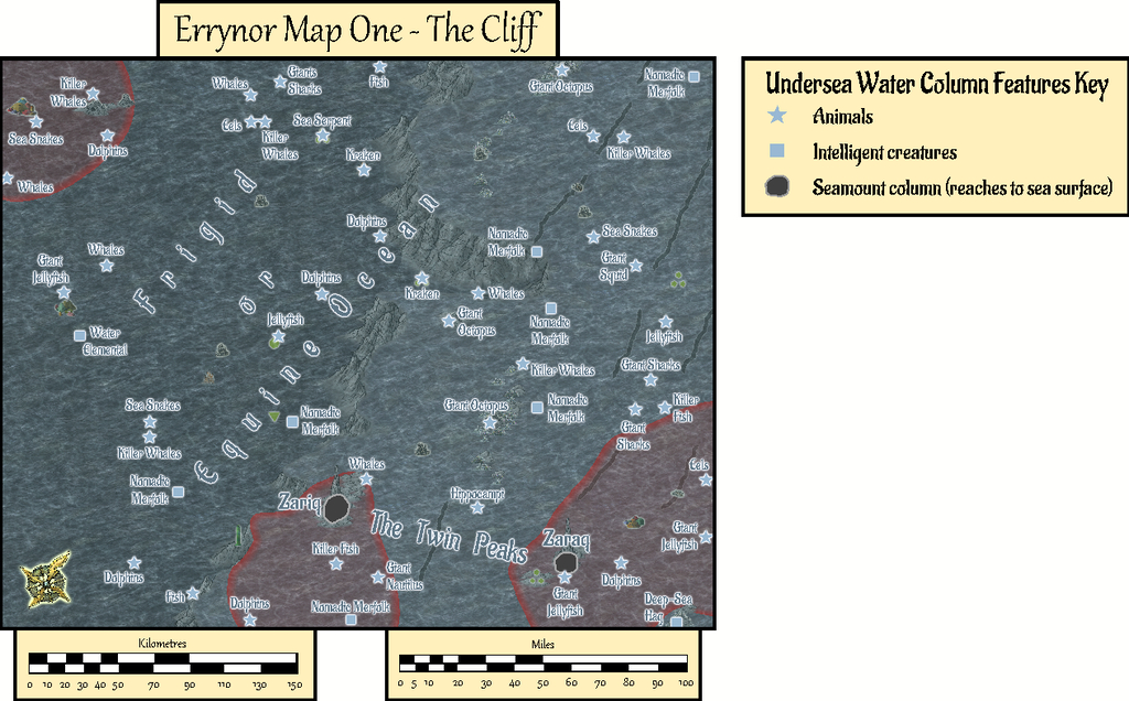
This view isn't at a fixed depth below the sea surface, simply to illustrate in general what can be found somewhere in the water column. Thus although the great seamount rock columns of Zariq and Zaraq have been given physical dimensions here, those are representative only. An 11-page PDF of the map's accompanying text-file notes explains this, together with detailing various of the other more noteworthy features shown.
A third toggled view, turning on the COAST/SEA Layer, shifts us to the sea's surface, where the seamounts have become small islands, and the midwater denizens have been joined by several ghost ships and an area where floating wreckage collects from time to time:

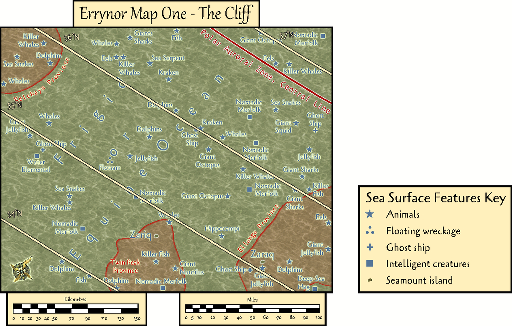
By turning off the SYMBOLS, SEA SURFACE Sheet, the paucity of sea surface features is very clearly seen!
GMs here may be unsurprised to learn I became distracted by some of possibilities of this map while drawing it into CC3+, as I've hinted in some of my more recent Forum posts here. Consequently, instead of progressing immediately to the next Errynor sub-map, I embarked on a group of feature maps from this one first. Plus, it also seemed unhelpful to not provide some guidance regarding the nature of the undersea features, especially the sea-bed settlements, for future mapping, as this is something scarcely touched-upon by published RPG settings and adventures. Thus this one map has become merely the first in a package of around twenty from this one area, which explains much of the delay in getting them ready for the Atlas, given I felt the whole group needed to be finished before any were submitted, in case changes were needed to those prepared earlier in the sequence - and that has happened along the way.
In fact the maps were prepared relatively quickly in each instance with CC3+. The most time-consuming aspect has been preparing and checking the detailed write-ups for them, as these are what has particularly allowed me to explore and expand upon ideas regarding fantasy undersea environments that I've been mulling over in part for decades.
Rather than drop the entire set on Monsen at once, my intention is for a gradual "release programme" with a new map or map-group only every few weeks. Maybe this will give me time too to complete more of the "Errynor 40" maps along the way, hopefully not taking quite so long each...


-
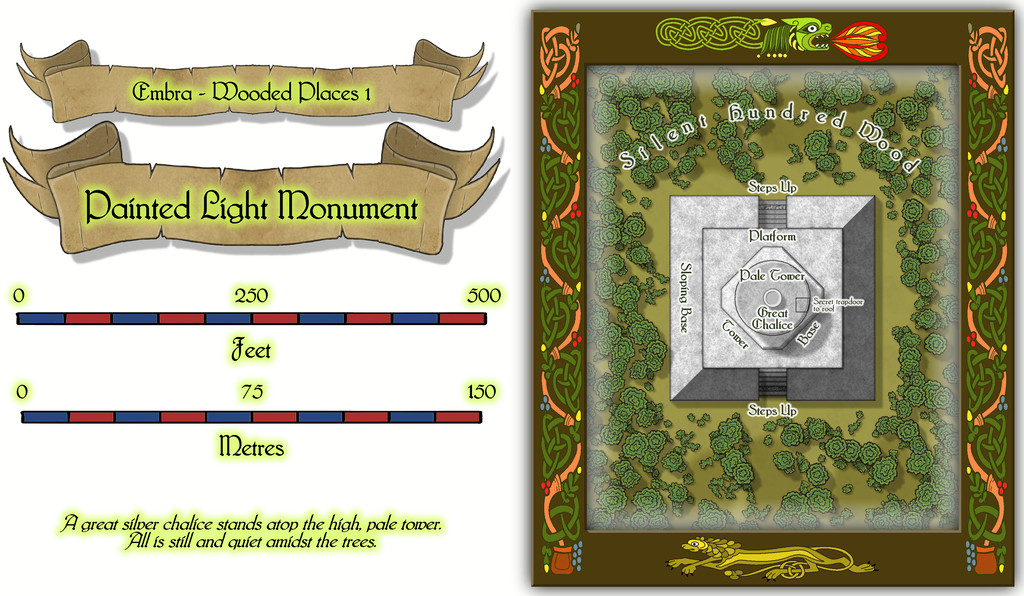
Community Atlas: Embra - Wooded Places
The opening map in the group, for the Painted Light Monument, was based on a design from the old Judges Guild "Temples I" book. As noted previously, these maps are smaller in scale than those in any of the other JG books being used as bases for the Embra Places maps, so this too needed a smaller CC3+ layout:
Which of course also reveals the dragon and lion motifs used to further decorate these map frames.
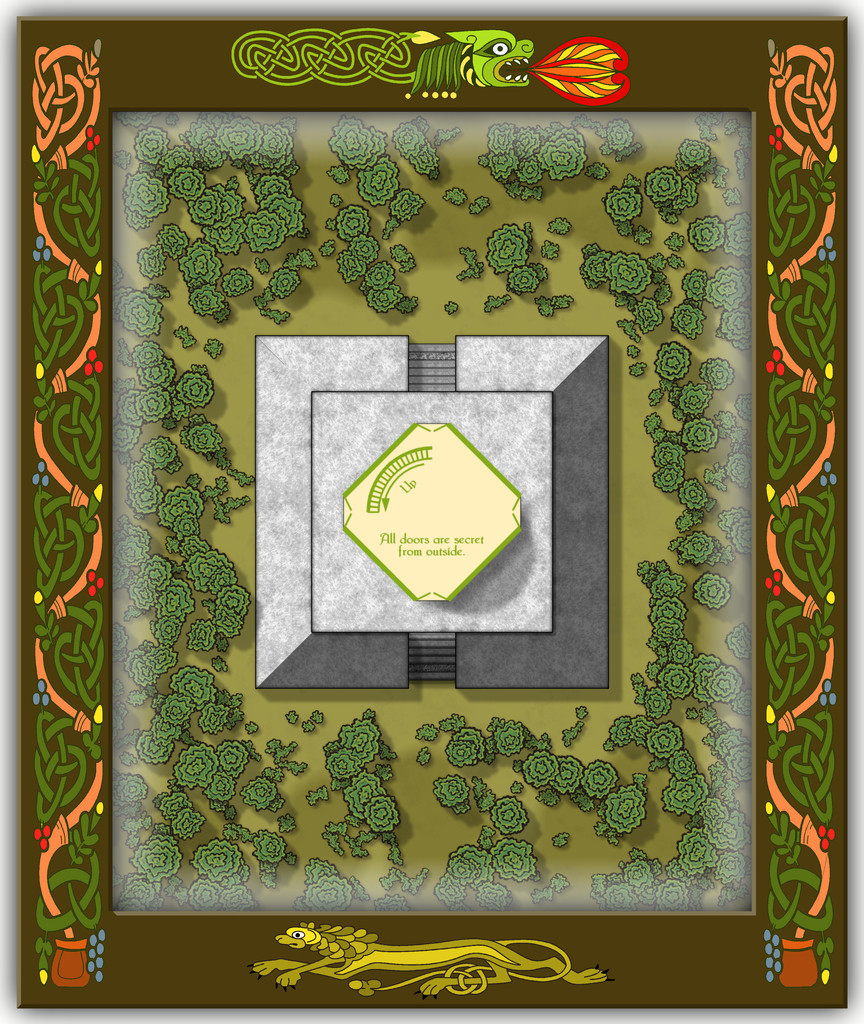
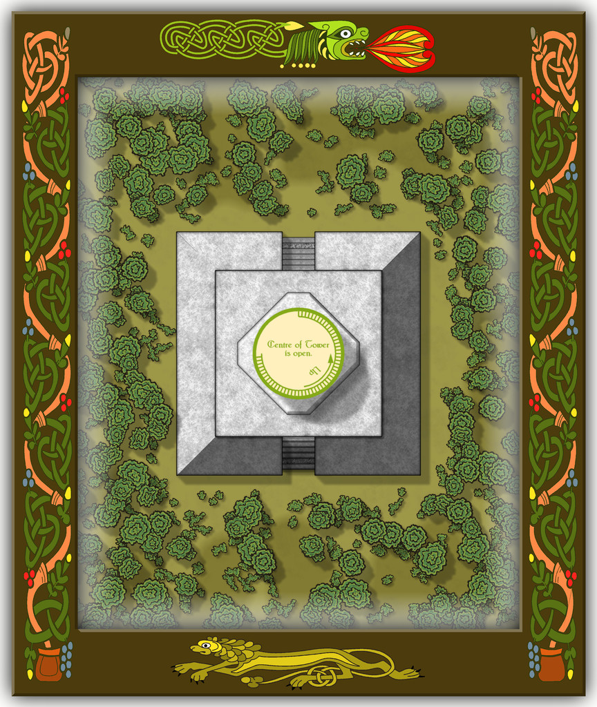
While a deceptively simple map with just a few shapes on it, apart from the omnipresent vegetation (Wooded Places, after all), as the central round tower is almost 90 feet tall (27 metres), there's clearly more to this than meets the eye, which the toggleable (FCW file) interior views should help demonstrate. First the lower level of the Tower Base (the map labels have to be turned-off for clarity when showing the interior):
Then a schematic mid-Pale Tower view:
Followed by one more for the highest interior view, just inside the roof:

I decided to add a few basic notes to each of the interior views as well, to help clarify exactly what was being shown. And yes, the number of steps IS accurate for the height of the tower, as the accompanying PDF and text files for the Atlas will reveal!
Speaking of steps, I had quite a few problems with the Effects on those little steps leading up the gentle angle of the outer part of the solid Sloping Base, as regardless of what I tried, there was - and indeed still is - a degree of interference between the stacked Sheets comprising them. This final version was the better compromise I decided was liveable with, where unless you're paying especial attention, the markings could be simply a bit of wear across one of the pale step stones.

![[Deleted User]](https://secure.gravatar.com/avatar/c75d9a245b74d9c59be0999ea81ca541/?default=https%3A%2F%2Fvanillicon.com%2F92add7f8c954488718110edc4896ad39_200.png&rating=g&size=200)
-
How long have you been using Campaign Cartographer?
Monsen asked: Do you remember why you went for the DOS version at that time?
To paraphrase from "The Simpsons" TV show, obviously...
"C:/DOS
"C:/DOS/RUN
"RUN/DOS/RUN"
😁


-
Community Atlas: Dendorlig Hall - A Sort-Of D23 Dungeon for Nibirum
Having at last managed to map the exterior region beyond the Hall to its south, Dendorlig Vale, and having just discussed it on the Forum, it seemed a good idea to update the state-of-play with the Hall itself today as well. My handwritten notes currently have reached area 201, while the type-up of these has reached area 160, all of which is easier to tell now, as I'm past the point where some areas were being written and typed-up out of sequence. The map continues to be amended in minor ways, notably in the placement of the area number-labels, after these, as noted previously, were enlarged some time ago.
Today's notes cover what was partly shown in the lower right corner of the previous sample map-segment here, the places formerly occupied by The Pegasus Club and the areas adjoining it (not all of which were directly related to the Club in their previous use). This is the map segment covering the areas involved:
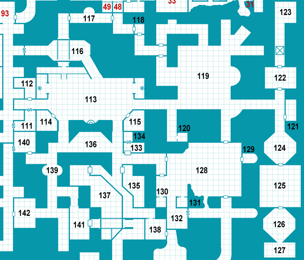
And these are the extracted PDF notes to go with the same areas (only):
As usual, both map and notes are subject to further amendment subsequently, as the text hasn't been fully checked still, while the project remains ongoing. Indeed part of the earlier notes posted here, which mentioned Dendorlig Vale, have been altered slightly too following the mapping of that external region, to reflect how the map actually turned out, rather than how it seemed it might earlier!
Further updates should follow, if all goes to plan.
[EDIT: And if only I'd realised this would have had the Forum-added note "28 Days Later", I might have made some post-apocalyptic comment as well 😉. Too late now though...]

-
[WIP] 1000th Map Competition: Elkton, Alarius North Central
Well, were-elks are we going to find them 😎 ?

-
Community Atlas 1000th map Competition - with Prizes [August/September]
The fifth map in my Whispering Wastes set is the weird necropolis setting of Osalin Village:
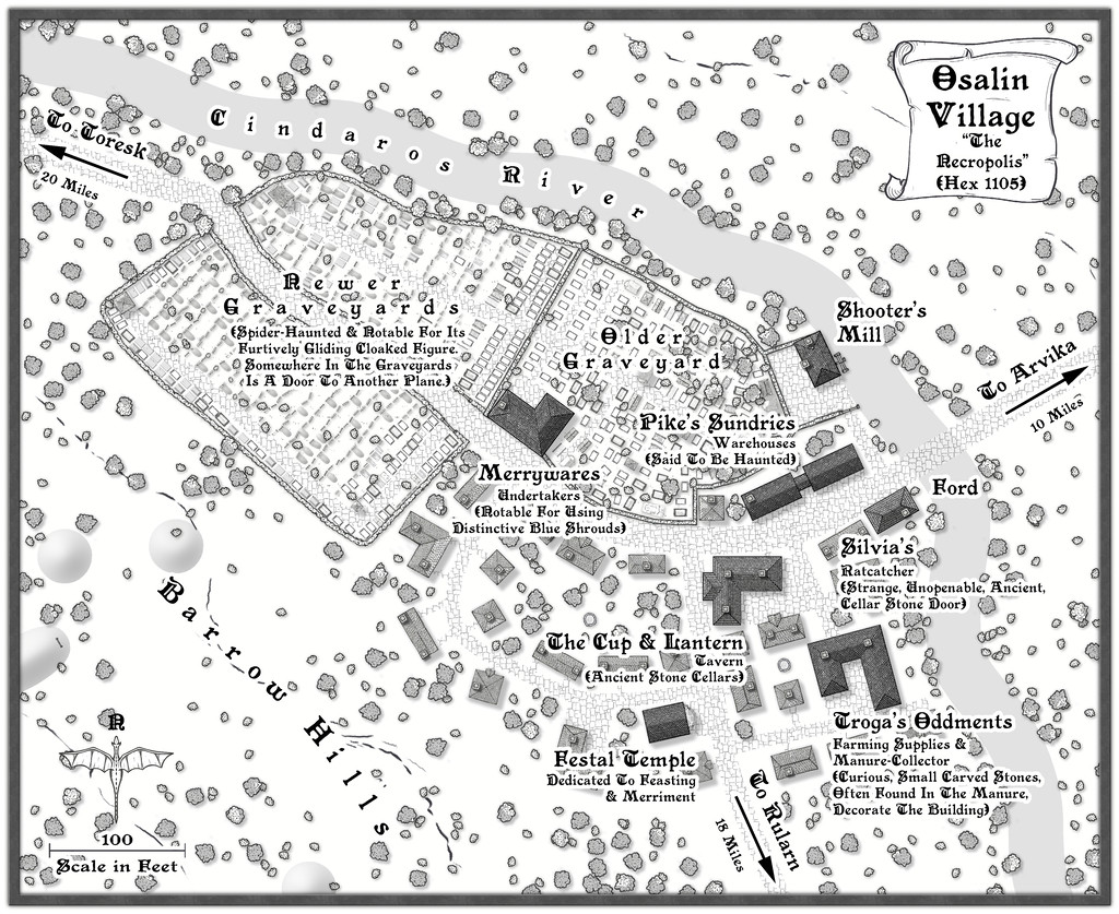
I've added some fresh notes about it to my WIP topic, and there's a higher-res map in my Gallery for this place too. Meanwhile, the FCW and PDF notes files are here:


-
CA style development - "Darklands City" (issues for September and December 2021)
@Loopysue asked: Does this look like how you would imagine a chimney fire from directly above?
Possibly, though it's quite common to have a heavy plume of smoke above the fire, so you can't see the central flame so well. Chimney fires have a tendency to produce copious amounts of dark smoke, sometimes with embedded sparks, which tends to be more what you'd see, particularly given the chimney itself is relatively tiny compared with the smoke plume. As house chimneys often kink inside, you might not be able to see the blazing soot unless it's near the top of the chimney anyway. From memory, the flames tend to be redder as well, though this is from the perspective of viewing from the side, rather than top-down.

-
Live Mapping: Starship Deckplans
Should be no tribble to do so...