


Wyvern
Wyvern
About
- Username
- Wyvern
- Joined
- Visits
- 3,303
- Last Active
- Roles
- Member
- Points
- 5,647
- Rank
- Cartographer
- Badges
- 24
Latest Images


-
Community Atlas: Queen Mica's Scintillant Palace
The central, main, part of the Palace complex, consists of the Level 1 map(s) above, and the other four earlier "Hive" maps, with suitable amendments:
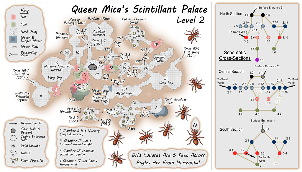
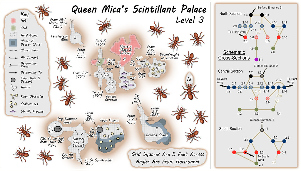
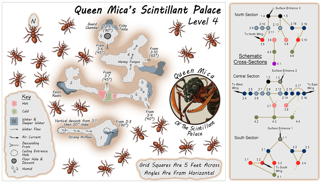
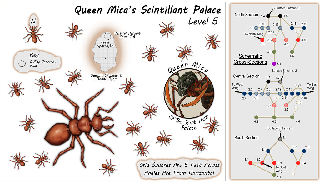
One major change was the original "Hive" was a single map, with each of the five levels set-up on a separate Layer in that FCW file. Here, each Level is in its own separate FCW file, as that seemed easier to try to keep things properly organised for presenting in the Atlas (although the Level 1 map still works that way, for its variant "Reality" and "Illusion" versions).
As the accompanying descriptive files suggest, the illusory nature of the Palace might be continued for some visitors, as GMs could prefer, throughout an entire visit here. Although no further illusory versions of the maps are provided, the idea is the level maps would be simply inverted, so as to seem that deeper levels below ground were actually higher buildings and towers, with suitable illusory views across the surrounding countryside and neighbouring parts of the Palace. Naturally, none of the locals are deceived by any of this, and now tend to give the place a wide berth, though less because it's really a giant ant colony than because the Queen, while respected as a powerful Faerie creature, isn't the greatest company over any length of time. Plus honey fungus for a meal or two is fine, but not on its own as a regular diet. Unless you're a giant ant, that is.
![[Deleted User]](https://secure.gravatar.com/avatar/c75d9a245b74d9c59be0999ea81ca541/?default=https%3A%2F%2Fvanillicon.com%2F92add7f8c954488718110edc4896ad39_200.png&rating=g&size=200)


-
New PF Blog Post, "10 Quick CC3+ tips", by Remy Monsen
Just posted on the PF Blog yesterday, this is a new, slightly eclectic, list of useful options when mapping with CC3+, by our own resident expert Remy Monsen. While the Blog posts are always worth seeing, this is one that's worth printing a PDF version of for future use, I think.
Some of the ten tips will likely be familiar, others things you know about but can never remember the times they're needed (like how to reset the "exporting in fewer passes" thing, item three on this list, and which I always end up scrabbling around trying to recall where I put the note as to what command has to be used to reset this, after a rare glitch that's reset it to the smaller amount!). And others may be new to you - OK, me, then 😁 (looking at you, Quick Move)!


-
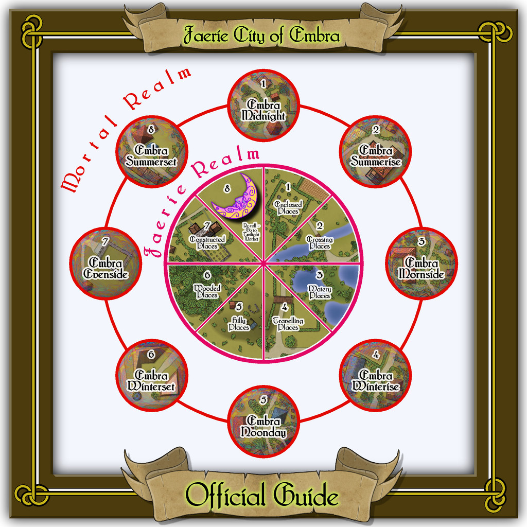
Community Atlas: Errynor Map 40 - Introducing the Faerie City of Embra
This first map of the 57 is designed to get visitors into the city from the outside world of the Clack Valley. A comparison with my early sketch for this link-map (shown above) indicates there wasn't much change along the way:
Indeed, its general layout was decided long before any of the other maps in the collection were prepared. However, this final form was among the last to be completed, thanks to needing extracts from some of those others. The frame decoration, as noted, is taken from the CA23 Map Border pack.
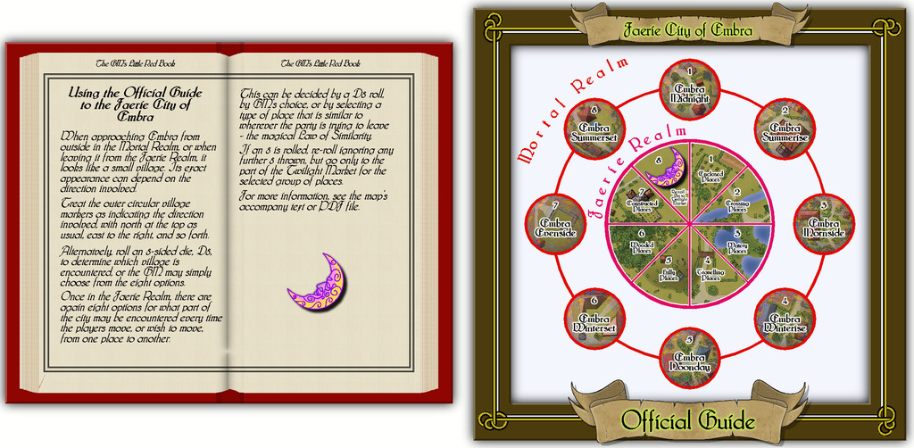
In the Atlas version, each of the numbered circles and central wedge-segments, except wedge 8, will link with their appropriate next maps in the Embra set. The outer ring of circles is the connection between the Mortal and Faerie Realms. Each circle leads to its separate Village map, showing how Embra appears from the outside, an appearance which can be different depending on its approach direction. As the names suggest, this outer ring is a compass-rose, representing in order north, northeast, east, southeast, south, southwest, west and northwest. GMs can opt to roll a D8, use the party's approach direction, or simply choose one of the Villages, to determine this initial connection. Similarly, when leaving Embra, the last place to be encountered will be one of these eight outer-ring Villages.
Segments 1 to 7 of the inner "pie-chart" connect with their respective "Places" schematic in the City itself, from where individual locations and streets within that type of Place can be accessed and explored. Segment 8 allows a random D8 roll to be used at GM's option to decide where a group may go next, as it provides the re-roll possibility mentioned in my earlier posting here, where the party would then be able to go directly to the Twilight Market from whichever set of Places was finally picked. GMs might alternatively decide by preference, or using the magical Law of Similarity, to select the next location instead. For example, if the party opened a gate to enter a field in whichever Village or Place they were in, by Similarity, they could then go to somewhere from the Enclosed Places selection. Had they been crossing a stream, they could have gone to one of the Crossing Places, and so on.
This is not necessarily all obvious from just the Official Guide schematic, and although there are PDF and text notes with the Atlas map, I felt it would be helpful to add some short comments to the map itself. By chance, the February 2022 issue of the Cartographer's Annual was published while this map was being finalised, providing an ideal opportunity to make use of one of its key elements as "The GM's Little Red Book". The full Official Guide map then, looks like this:


-
Community Atlas: Embra - Crossing Places
The next Place is Dragon Bridge, which of course is a Bridge along the back of a great sleeping Dragon (what else?):
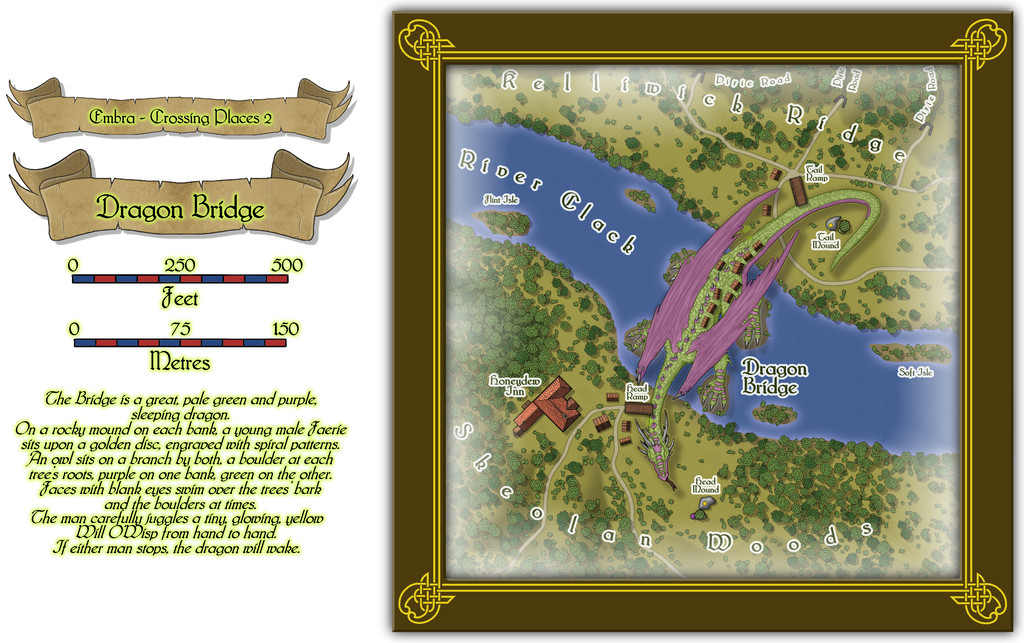
An explanation for how this works is provided by the featured text alongside the map, and the larger elements from that - rocky mounds, golden discs, trees and coloured boulders - have been placed on the map itself. It's clearly been working for a long time, judging by the wooden village that has grown along the Dragon's back, spilling over onto both river banks.
Interiors for the buildings should be available via the usual FCW file toggle in the Atlas (next image), with a second toggle for the upper storey interior of the Honeydew Inn (lower next image):
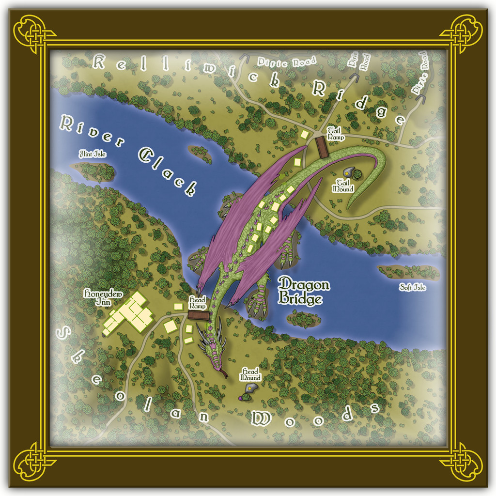
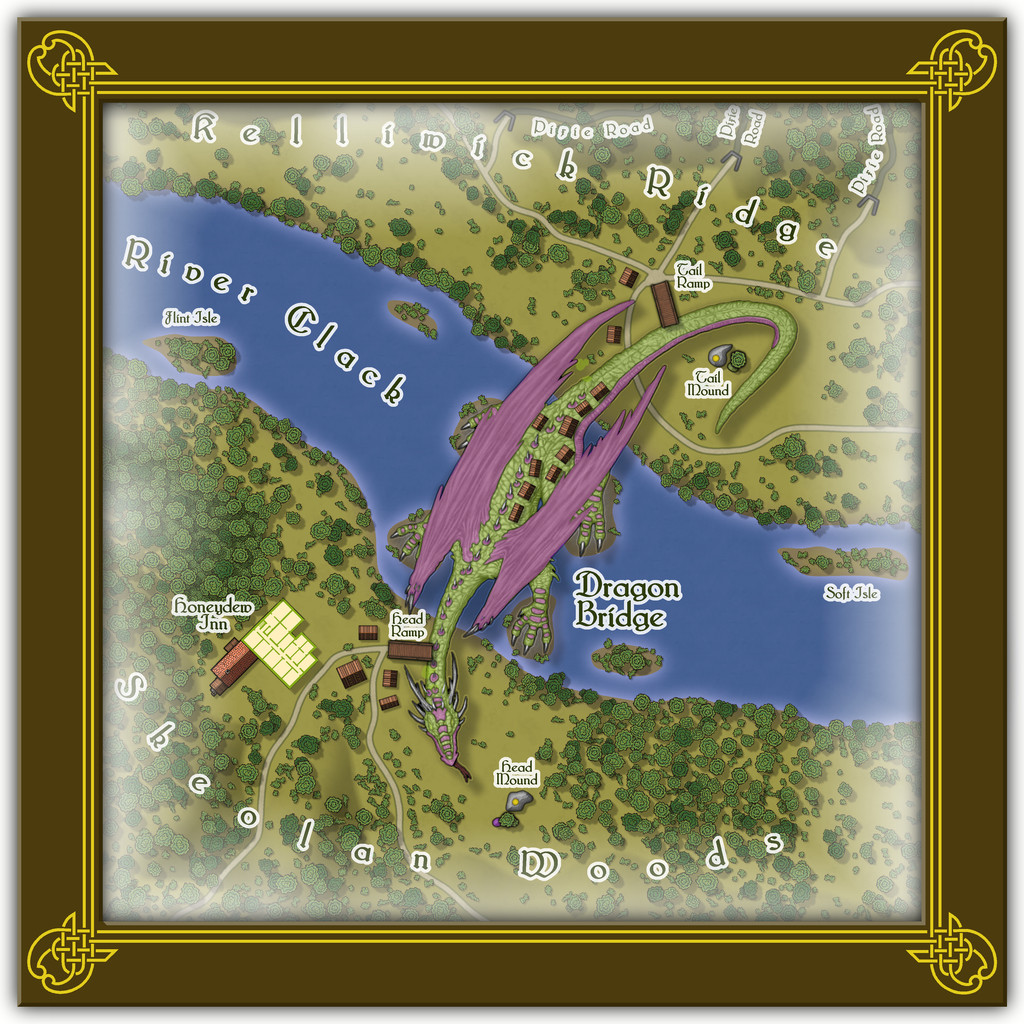
As commented already, the Dragon is a symbol, from DD3, but greatly enlarged. It's also a varicolor one, with added purple polygons to match the description of the featured text. As ever, there'll be PDF and text file notes available in the Atlas, which will tell you more about those mysterious, subterranean Pixie Roads through Kelliwick Ridge...

-
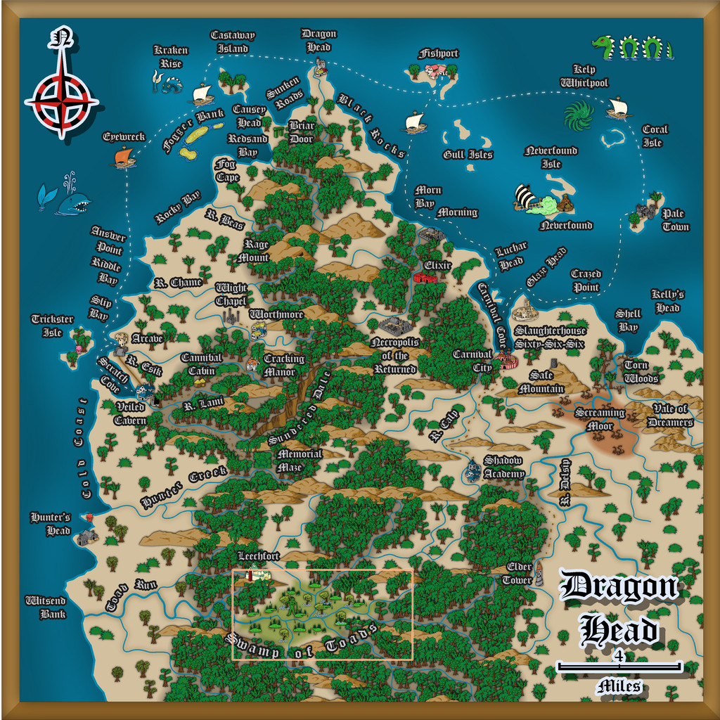
Community Atlas: Dragon Head, Lanka, Kumarikandam
A good deal later than I'd hoped, delayed thanks to various events outside my control, the next batch of maps for my sort-of Dungeon24-25-2... project are finally completed, covering aspects of a small peninsula on the northern shores of the easternmost Peninsula of Lanka, Kumarikandam:
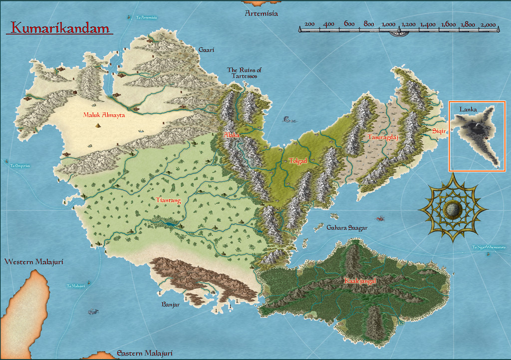
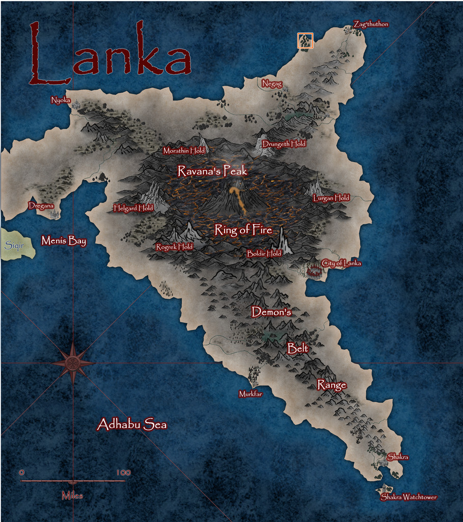
Lanka's pre-existing Atlas notes described it as an ashy, blackened, barren, volcanic wasteland, home to demons, dragons, dwarfs and assorted other (probably inimical) humanoids. However, peering closely at the Atlas map for the peninsula, there are a few spots with trees, shrubs and other hints of vegetation, some of which have settlements marked nearby, so it's not entirely desolate. And it was one of those vegetated headlands that I finally settled on mapping, from this extant base (extracted from the map above):
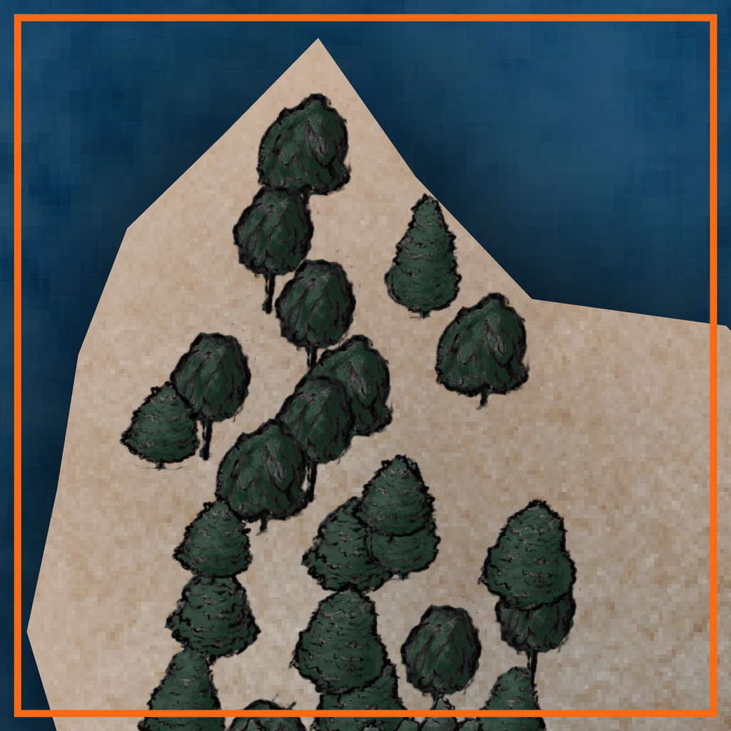
That orange-outlined area is some 20 miles square (30 km or so), to give an idea of scale.
A group of locations where sites of interest could be placed, were randomly assigned, much as usual, and then ideas for what they might be were drawn from, or inspired by, prompts from The Story Engine's "Deck of Worlds" and its expansion card sets, with some from the main "Story Engine" deck and its expansions too, including "Worlds of Blight & Shadow", "Written in Ash & Bone", "Worlds of Myth & Magic", "Worlds of Tide & Tidings", "Heroes' Quests & Fools' Errands", and the "Story & Worlds Bridge Expansion". From which you can tell I was leaning heavily into the "doom and disaster" concepts from the previous map's notes...
With that completed, the map was starting to come alive more, which, thinking about its geographic location - right on the equator - helped firm-up further. I was tempted to run lines of low hills into the gaps in the pre-mapped wooded areas, on northeast-southwest lines, only to decide against that (although hints of that still survive in the final map) as some of the ideas that had begun to coalesce favoured more west-east lines instead, partly based on what and where the random features were placed. These also gave rise to a number of offshore items, many of which were turned into islands too small to be shown on the original (honest!).
Thinking of what mapping styles might work best for this generally "threatening" area brought me eventually to the Dark Fantasy Maps style (CA140), to which were added items from the SS1 Fantasy Color style too, as suggested by the CA140 PDF Mapping Guide. After which, mapping commenced:

To keep things nicely confusing, "Dragon Head" is the name of this whole peninsula area, a coastal village settlement on the peninsula's northern tip, and the name of that headland where the village is sited! More hints of oddness feature in other map names, which the PDF map notes in the Atlas expand upon, as usual. There are definitely Dwarves, Demons, (Demi-?)Gods, Cannibals and Undead in places though, not all necessarily in what might be considered typical forms, along with still weirder things...
Speaking of which, the jungles have been kept deliberately off the hills for a couple of reasons. One is to further enhance the slightly uncomfortable feel of the whole area - rainforest jungle, but maybe the rain here isn't so healthy as it might be (the locals say it's often so heavy, it strips anything less tenacious than grass from the uplands). Plus the land has been tainted by events elsewhere across Lanka that laid waste to so much of it. The other main reason though was because when designing this map, I was also reading a couple of books on the Guadalcanal campaigns of 1942-43 in the Solomon Islands. Those islands are covered in tropical rainforest jungles, yet on Guadalcanal, as period photos clearly show, the hills are bare of anything much larger than scrubby bushes and grass, including from before any fighting began there. That contrast was just so unnervingly striking, it seemed very apt to reuse it here.
The dungeon map was originally going to be located on the western flanks of the narrow, crevasse-like canyon of Sundered Dale, near this map's centre. However, I found I was struggling to find reasons to so-locate it, and exactly how it was going to work there, because part of the design from the Inkwell Ideas Dungeonmorph Dice showed a large clump of trees in an open air circle, in the centre of a large, partly-roofed, temple-like chamber.
Inspiration for where else it might be placed, and just what it might be, came unexpectedly during a YouTube livestream on Free RPG Day 2025 by The Story Engine, creating settings with various guests using their card decks and expansions. One feature option that wasn't immediately spotted by the streamers was "Fence of Toads", and as so often in the live chat, we went off on our own little tangent about that... Then the stream's organiser, creator of The Story Engine decks, Peter Chiykowski, spotted our tangential chat about the point where I'd mentioned I'd then very recently been designing a "Swamp of Toads" (for this Dragon Head map). He said he'd love to see that, half-jokingly, and so was born the decision to expand the Swamp of Toads into a complete, separate Atlas map!
In case you can't spot the Swamp immediately on the map above, it's here, and we'll find out more about it next time:

-
Community Atlas competition entry: The Summer Palace of the Winter Queen
As mentioned a couple of days ago, aside from the mapping, I've also been pulling together the notes to accompany this set of maps, so for those who might be interested to know more in advance, here are the general comments from the start of that file, as drafted to date.
No one is quite sure who or what the Winter Queen really is. The rare tales mentioning her suggest she may be a deity or an exceptionally powerful, probably immortal, perhaps Faerie, creature. Few such tales give useful details on her nature, though many cultures in the higher northern and southern latitudes of Nibirum preserve variants or fragments of the stories, where the Queen has numerous alternative, typically apotropaic, local titles. It is clear she is thought to possess great magic, much exceptionally obscure knowledge, and a considerable burden. Humanoid in form, she appears as very tall (around 8 or 9 feet high; 2.4 to 2.7 metres), dressed in a long, hooded robe, with piercing blue eyes, bearing a long white staff or crook taller than she is, and an air of great sadness. Her clothing and physical features are said to alter subtly from one day to the next.
She cannot leave the Palace, and has no control over where it goes, as the Palace moves magically, and instantly, once a day to a new location. It is said to be never in exactly the same place twice, but its location is always in an icy, remote, spot, concealed below the surface. Its solitary entrance, while small and hard to find, has no door (there are no doors throughout the Palace), and can be recognised by the profusion of perfect representations of summer flowers and foliage all around it, made of crystal-quality ice. This summer array of perfect specimens is astonishingly beautiful, all of which objects are very fragile. Damaging any is a swift way to raise the Winter Queen's ire, something the tales strongly warn against.
Wherever the Palace alights and for fifty miles around (eighty kilometres), the weather worsens and turns wintry, if it was not winter when it landed. Sometimes, it settles in the clouds, where it stirs them to winter storms, pouring hail and snow down to the surface beneath in icy gales. Even then, the Palace remains deeply hidden by the clouds, for all it still has its ice-flower-surrounded single entrance.
While some tales allude to it, one reality about the Palace is that the souls of all who have died recently in the frozen places of the world, and all those who have died from cold elsewhere, must pass through it on their way from wherever they were to wherever they may be going. A few may linger in the Palace for a time, and some may become temporary guests or servants of the Winter Queen. The Queen has no control over which may stay or move on immediately, however. She frequently converses with those passing through even so, from which much of her secret knowledge derives. Occasional tales may hint disparagingly that the Queen is merely running a ferry service for the recently deceased.
The Palace changes its form whenever it moves, never the same twice, though always in plan-view having the shape of a gigantic snowflake, with walls, floor and ceiling composed entirely of solid, if at least slightly translucent, crystal-like ice. This is always beautiful, with glittering facets like gems that reflect light on or just within the solid ice surfaces. Somehow, light palely manages to illuminate the whole interior with a soft radiance, no matter how deeply buried the Palace may appear to be. At times, rainbow-coloured beams, arcs and spots may be seen, like haloes in the outdoor sky that are created by refraction of sunlight through tiny hexagonal ice-crystals in thin, high-altitude, clouds. Sometimes such light effects may become dazzlingly bright briefly. The ice walls, floors and ceilings reflect light as well, which in places can take on a mirror-quality surface. Such mirrors can allow glimpses of past or future events and places, memories left by the passing spirits, perhaps. The Winter Queen does have some control over such light, vision, visionary and illusory effects within the Palace.
Queen and Palace are so inseparable because in essence, they are parts of the same thing. Many of the Queen's "servants" are actually living ice-constructs which appear from, and can return into, the inner ice surfaces of the Palace as required, thus too are simply another element of this whole being.

-
Paper Modelling (October 2021 Cartographer's Annual)
Thinking further about this, it occurred to me it might be helpful to provide a list of manufacturers that produce, or have produced, downloadable card and paper models, with website links. I'll not pretend this will be fully comprehensive, but it may give some more precise pointers than simply advising people to go and hunt through the OBS sites and CWF. Where not noted, the scale is generally the "standard" 28 mm-32 mm used for most fantasy and science-fiction gaming (which of course isn't a true scale at all, but what can you do?).
Antohammer the Lonely Wargamer: Mostly 2D standee paper minis, with some 2D, 2.5D and occasionally 3D models as well (of terrain features, smaller structures and a few vehicles), fantasy and historical.
Arid Hills Gaming: A limited range of 2D, 2.5D and 3D fantasy and science-fiction gaming terrain and props (e.g. for dungeons and graveyards). Manufacturer has now though switched to 3D printer files only.
Avalon Game Company: Mostly paper minis (plus a massive collection of written RPG accessories, gaming floor tiles, tabletop print-and-play games and accessories), with a limited range of fantasy 2D and 3D scenery, e.g. for dungeons.
Black-Ronin: A small number of 15mm-18mm scale 3D exterior modern buildings and structures, and 2D floorplan textures, intended for historical wargames.
Crooked Staff Publishing: A VAST and increasing range of Pay What You Want texture packs for creating your own scenery. The guy who is the company, Kristian Richards, also produces regular short YouTube videos (59 so far!) on using these to make 2D, 2.5D and 3D models (attaching the texture to various types of card and foamcore first, very often), and has an enthusiastic Discord channel. Although not specific models as such, the PDF file textures could be easily converted and transplanted for personal use in CC3+ to draw specific models using them in Dioramas 3, for instance. The videos are especially to be recommended for new card model builders, and mappers particularly may care to view the, currently 4, "Tiny Terrain" videos, which are in essence 3D hexmaps!
DarekPages: A small, occasionally growing, range of 3D terrain models, some vehicles and 2D minis, for near-future/science-fiction settings (although some items will work for fantasy too), with comprehensive photographic instructions.
Dave Graffam Models: A huge, still growing, range of 3D, mostly exterior-only, models for fantasy and science-fiction settings, with 2D ground tiles as well. Instructions provided with each kit, many of which make heavy use of the PDF layers facility, so each model can be built in a variety of appearances.
Eddnic: All-free, more-or-less unique 3D paper minis, and some 2.5D and 3D fantasy prop models (HeroQuest-style, after the 1980s fantasy boardgame of that name). Not for beginners, as some can be very difficult to make, there are NO instructions, and searching through to find what might be of interest is a challenge in itself (as it's purely a blog site), but the models are often astonishing and - as mentioned - free + unique!
Epic Wargaming also known as Print and Play Fantasy: Primarily wargame-style 2D fantasy standee minis, but there are a couple of 3D models as well, notably a castle on the Wargame Vault site. A major website failure three years back has meant the ranges are still incomplete on the new site, although new minis are produced from time to time. Many of the minis are free, though some are Patreon-only items now.
Fat Dragon Games: A large range of mostly 3D buildings and terrain (for possibly the greatest number of biomes available anywhere in papercrafting), the later models often making use of the PDF layers feature to extend the options for how the final models can appear. Mostly fantasy structures, with some science-fiction, although the natural landscape terrain has many more uses. The owner has switched to 3D printed models only now, so the existing paper-model range is unlikely to expand further.
Finger and Toe Models: A large range of 3D building, structure and vehicle models for fantasy, historical and science-fiction settings. Mostly exterior-only models, and provided with illustrated instructions.
Haunted Dimensions: A host of horror-themed, free, 3D models, games and some minis. The models are chiefly exterior-only, though they do include the Bates and Amityville houses from their respective movies.
Helion & Company: Their Paper Soldiers range of hardcopy and PDF books each contain complete pairs of historical wargame armies of minis, basic rules and usually some 2.5D or 3D terrain features and miniatures, and come with full instructions. Two sets, "European Buildings" and "Castle Assault", are especially heavy on the 3D buildings side!
Hotz Stuff: A range of 1/300 scale historical naval wargame minis, including 3D ship and building/structure models, plus a range of 30 mm (1/60 scale) Wild West buildings and structures. No new items in more than a decade, however.
Kingsway Models: Mostly hardcopy-only OO-scale (roughly 1/76 scale) historical British railway model structures and buildings, with a few free downloadable PDF items. Some 1/43 scale (O gauge) items also available. Print quality on the hardcopy items is often not as good as you would hope, from personal experience, and this is true also of the PDFs.
Lord ZseZse Works: A range of 3D models (as well as lots of 2D ground-tile flats), primarily for fantasy settings, and including some terrain features as well as structures. Also a few 3D vehicles (historical Russian tanks). Unfortunately, after a very successful Elven Papercraft KickStarter campaign in 2014, the company ran into problems delivering all they'd hoped to from that, and although all their models remain available for purchase, no new models are likely, as the owners split-up in 2017.
Mystic Mountain Productions: A modest range of fantasy 3D buildings, mostly exteriors, though some with internal 2D floor plans as well, with comprehensive photographic instructions. Often makes use of PDF layers to enhance the final appearance options. No new models since 2017, however.
Okumarts Games: A large range of mostly 2D standee paper minis, but also produces some 2D, 2.5D and 3D models (dungeons especially in the latter type), mostly for fantasy and science-fiction settings, also some historical minis. Detailed photographic instructions are provided for the models, and the PDFs nearly always make much use of the PDF layers facility.
One Monk (also known as Mayhem in Paper) : Although One Monk produces chiefly 2D standee fantasy minis and a few 3D vehicles, their main website also hosts a huge repository for many free minis and models created over the years by the papercrafting community, in recent years via the Cardboard Warriors Forum's "Monthly Hoard" system, or produced by individuals outside that.
Papercraft Dungeon also known as Kev's Lounge: A range of mostly 2D paper standee fantasy minis, with a small range of 3D structures, the buildings coming with full external and internal artwork. The build mechanics can be complex for the structures, and although photographic instructions are provided, they work better for those with plenty of paper model-making experience. Tending to concentrate chiefly on standee minis only in recent years, however. In addition, not all the models are available via the OneBookShelf sites (the link above), and the owner's site, Papercraft Dungeon, while allowing easy paid-for and free downloads, will only let you download each item in your account a limited number of times - so make plenty of back-up copies!
Papermau: An extensive, very long-running blog, which serves chiefly to highlight some of the many paper model creations freely available across the Internet down the years. The blog's author also makes new, usually 3D exterior-only, models from time to time as well. Being Brazil-based, a few of the blog posts in the past two years have become rather politicised, which may be something to be aware of.
Paper Realms: A large and growing range of 3D exterior buildings, 2.5D/3D subterranean and ruin models for historical and fantasy settings, with some props sets and ground tiles, and some overground 3D terrain models, including options via PDF layers, and instructions.
Papier Schnitzel: A substantial and growing range of mostly historical 3D model structures and ships (Dark Age Europe and Medieval Asia, primarily), usually with full exteriors and interiors, making extensive use of PDF layers, and provided with detailed, photographic instructions.
PERMES: Chiefly a 2D standee minis producer (vast range; historical, fantasy and science-fiction), some of the sets do come with pieces of 2D or 2.5D terrain as well, and a few packs are chiefly of this sort. Instructions are not always provided, so some experience with paper modelling is necessary to get the most from these models.
Ravensblight: The "Toyshop" section has a substantial range of free horror-themed 3D exterior-only buildings, games and vehicles, including full-sized novelty items. Commonly added-to around Hallowe'en in most years, in some cases with RPG/story notes as well, plus separate PDFs with instructions.
Reviresco Tin-Soldier: A small range of mostly exterior 3D model vehicles, structures and buildings, making use of PDF layers to swap things around at times, and with useful, illustrated instructions.
Scalescenes: A growing range of British model railway structures, buildings and some vehicles, available in OO (1/72) and N (1/148) scales and with different exterior texture options (though only one scale, and one texture option, is provided in each paid-for downloadable model). Illustrated instructions come with each kit. Look out too for the free downloadable PDF scale rulers!
Stoelzel's Structures: A large range of highly detailed 3D models with full interiors and exteriors, often with props, and comprehensive instructions, suitable for near-modern and horror settings particularly, with some fantasy items (such as caves and dungeons). PDF layers are not used, so there are commonly huge numbers of pages per PDF, which can make it difficult to keep track of what to print when there are options available. Also relies on the use of foamcore to retain the correct wall thicknesses, so the walls are simply covers for that.
Tinkering Tom: A small selection of 3D building models, fantasy-historical in nature, complete with illustrated instructions.
Wordsworth Model Railway: A substantial range of British OO scale 3D exterior railway model structures and buildings, all free. Also a YouTube channel with a huge number of construction videos. Video 92 is recommended for beginners by the company, as a 10-minute general introduction to making card buildings.
World Works Games: A large range of 3D fantasy, horror and science-fiction model structures, buildings and some vehicles. Unfortunately, the range is no longer supported, so is unlikely to further expand. In addition, the kits are all available only through the company's own website, and it too is not regularly maintained, so in recent years, it has been frequently, and unpredictably, offline for unexplained reasons. As only a limited number of downloads are available from each purchase, be sure to make plenty of extra back-up copies of anything purchased from the site.


-
Community Atlas competition entry: The Summer Palace of the Winter Queen
Along the way, I let myself get a bit distracted, and decided a CA3 portrait of the Winter Queen might be an interesting addition to the map set, with a hint of the SS2 Bitmap A Snow Frozen Lake fill texture for the border design, which thanks to the standard CA3 bevel effect, looks rather like fine marble now:
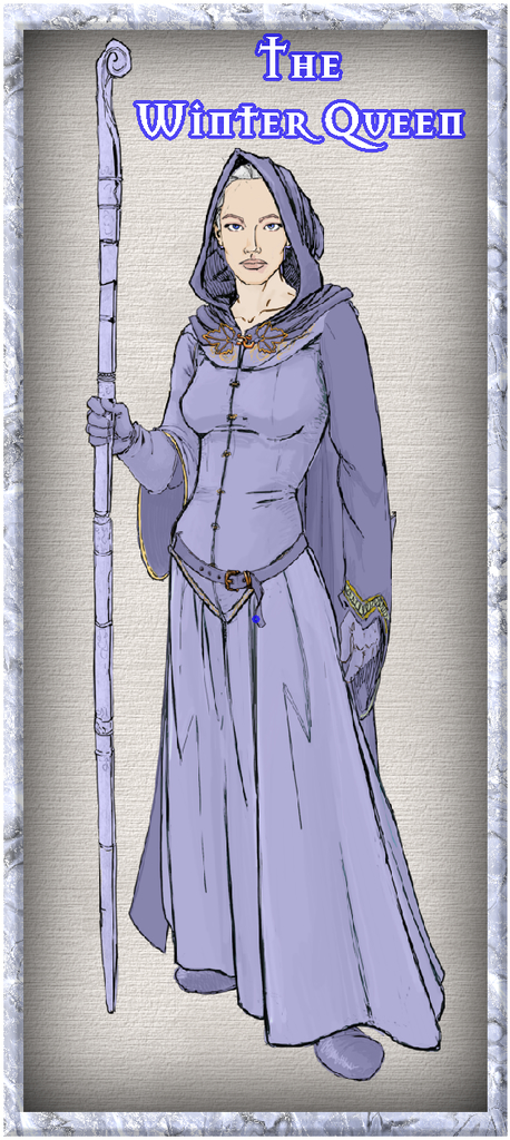
She's intended to be between 8 and 9 feet tall in (imaginary) reality, 2.4-2.7 metres.


-
Community Atlas: Ruins of Shadow Keep, Malhavania, NW Doriant
As mentioned last time, the next map in this sequence was heading for somewhere in the NW Doriant map, a huge part of that largest continent:
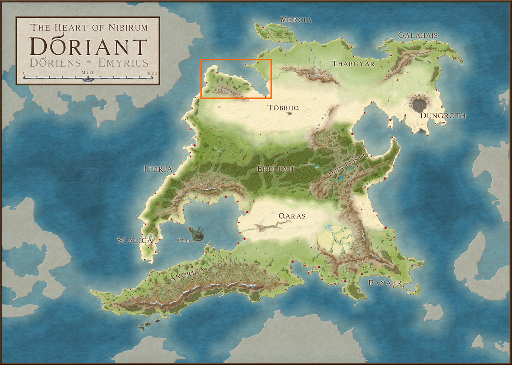
However, when I investigated further, it turned out the Malhavania peninsula there had already been mapped previously. While itself no small region, that did start to look a little more hopeful:
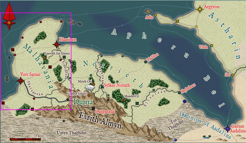
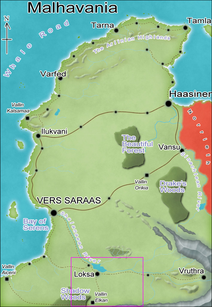
Checking the smallest pre-mapped part of the Malhavania one, around Loksa, clinched things, with its convenient selection of interesting potential sites available to slip-in a small, new, dungeon map:
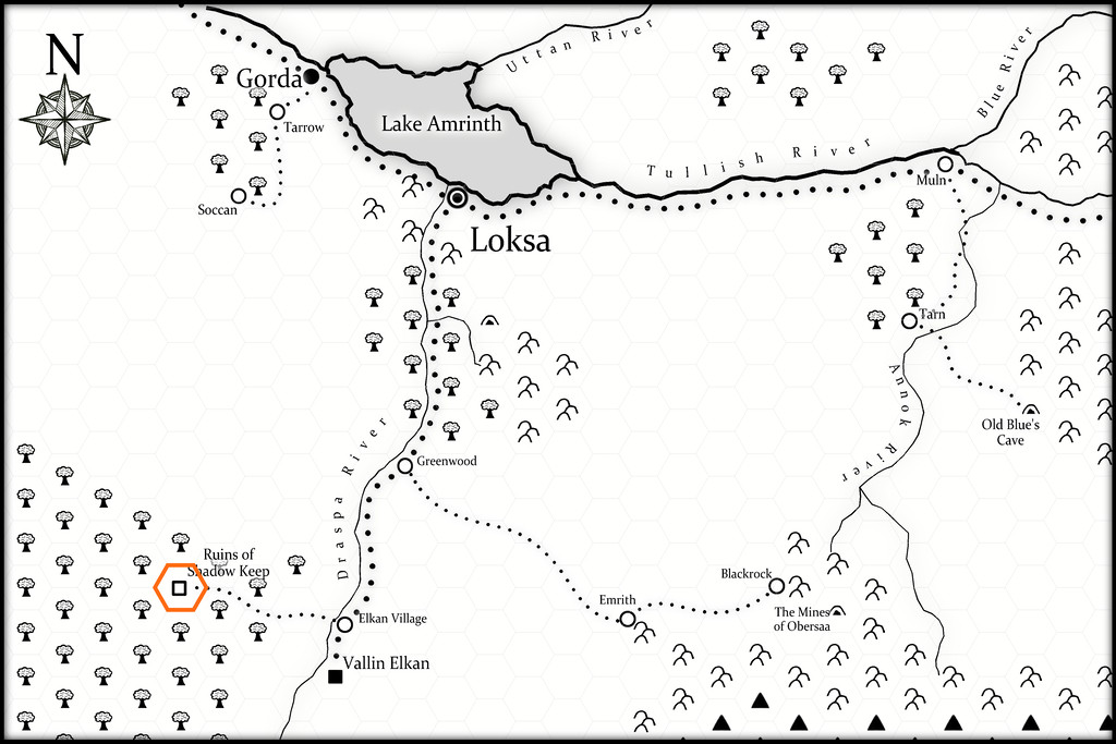
As this final map indicates, I chose the Ruins of Shadow Keep for this site. It's probably not too obvious at this resolution, but the black-and-white area is covered by a hex-map (drawn for the Atlas by Kathorus), with six-mile hexes. I did consider mapping the whole hex, but decided against it finally, mostly because the previous map-group I'd prepared had already been so long delayed in being completed.
The dungeon design was derived this time from randomly-rolled layouts using the Inkwell Ideas Trailblazer Set of Dungeonmorph Dice, the first of the four designs prepared from this set, though I did make a few minor changes to fit better with how things developed for what the contents and purpose of this structure might be/have been ("Ruins", after all). Much of those contents were determined using random tables from the revised edition of "The Tome of Adventure Design" published by Mythmere Games. I only realised after doing so that the Trailblazer dice set actually does have accompanying notes in a separate Inkwell Ideas book! Still, there are three more designs from that set after this one, though I did take a few ideas from that book as well, notably that the original inhabitants of Shadow Keep had been Dwarves, that part of the complex had been a temple, and that another part had been kennels.
One thing the "Tome" came up with were some very weird creatures, which rapidly became the focus for why the Keep had been abandoned and ruined, the Elemental Wasps. From the notes prepared to go into the Atlas: Elemental Wasps. Horse-sized, hairy, spider-form, colonial, egg-laying outer horrors, with three spherical body parts - a small head, medium body and larger abdomen - the body segment with 8 or 10 pincer-tipped legs. Normally invisible, except during and after feeding on blood, when their forms appear pink and sharply-ridged. Attracted to small, shiny objects that they collect as nests. May become ghostly and intangible at will. They have three forms, Queen, Forager and Warrior, of which the Forager and Warrior may cocoon to transform into any other type, as the Queen requires. Cocoons and eggs are always visible.
I also provided the creatures with relevant game stats based on the "Shadowdark RPG", published by The Arcane Library, for GM's guidance. To give an idea of what these (all non-flying) Wasps get up to, these are the notes for the Queen: Elemental Wasp Queen. An almost immobile form, with a huge, egg-laying abdomen and eight tiny legs. AC 12, HP 42, ATK 1 mental burst and 1 lightning cloud or 1 blood suck (near) +3 (1d10 + blood drain), MV close, S +3, D -4, C +2, I +0, W +1, Ch -4, AL C, LV 9. Blood Drain. Extensible head proboscis can hit one target in near. Once attached, may auto-hit each round as the Queen's only attack. Queen regains 1d6 HP per successful attack round. Target may DC 12 STR to break attachment on their turn. Lightning Cloud. Fills a double-near-sized cube extending from the Queen. DC 15 DEX or all within the area take 4d8 damage (DISADV on check if wearing metal armour). Mental Burst. Fills a near-sized cube around the Queen. DC 15 CON or paralyzed 1d4 rounds. Impervious. Electricity immune. Incorporeal. In place of attacks, become corporeal or incorporeal. Invisible. Naturally invisible. After using Blood Suck attack successfully, becomes partly visible. All who can see this, DC 12 CHA or paralyzed 1d4 rounds.
The other forms all have variant powers based on these, with physical pincer attacks as well, and they're a lot more mobile, able to climb vertical surfaces and so forth. There are grubs too, but they're unable to defend themselves, and need looking after by the other mobile types till they become adults.
All of which preamble brings us to the new map:
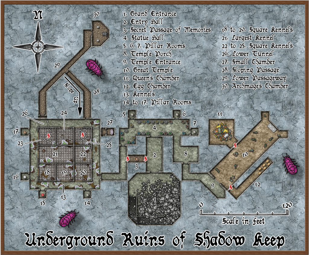
This also has a gridded version, although the angled areas work somewhat less well with that, of course:
The mapping style here started out as the CA94 Dwarven Dungeons one, given the initial inhabitants were, after all, Dwarves. However, it soon became clear that I needed other elements as well. SS4 Dungeons of Schley and the free monthly "Schley" symbols are already intended to work with Dwarven Dungeons, so that was fine. However, I also ended-up adding items from CA209 Stairs & Steps, Sue's Creepy Crypts (CA186 + CA188) and DD3! So using the Worn Manuscript font from Perspectives 3 wasn't much of a step further...
Of course, when you start a new map with Dwarven Dungeons, the first symbol catalogue that shows up has the cave bugs in it, so while they're not very close to how I envisioned the Elemental Wasps (except maybe the maggot-grubs), I thought they'd do to hint at Things To Come for explorers here 😉.
There is much other weirdness as well. The "Tome" provides opportunities to go to town when designing features such as statues, and having had it come up with a Statue Hall (4), all the statues in it now have individual descriptions in the Atlas map notes, based on those random options, as do the individual pillars in those seven Pillar Rooms (because you can also randomly design pillars using it!). Even the glowing hanging moss across the Kennels area (13 to 25) originated in tables there. The ceiling crevices from which it has grown down from the overlying jungle (the site is at about 25°N latitude on Nibirum) were though my own thought to explain how it got to be here at all, at least. Oh, and there are poisonous little spiders in it that keep away other predators...
One more weird item discovered late in the process concerns the Dwarven Dungeons scalebar. If you peer closely at the gridded version of the map, you may be able to tell the 10-foot grid squares do not match perfectly with the 20-foot marks on the scalebar. Ordinarily, when adding a scalebar symbol, I always check it against the grid, to make sure the size is what it's supposed to be and that I haven't messed it up. Commonly, I also place the centre of the scalebar using the snap grid, as a further test. Doing that showed this scalebar didn't fit to the grid, even after testing with adjusted symbol scaling, including trying the varicolor and metric scalebar versions, in case one worked. All proved identical, however. So then I measured the separation of the marks on the bar at scale-size "1", and found the separation between individual marks came out variably between about 15 and 17 feet, with no consistency, which of course explained things. I did think of swapping-in an alternative bar, but I wanted to try to stick as much as possible with the Dwarven Dungeons style here, so have just left it, given it'll still be sufficiently correct for most uses. Something to be aware of when mapping with this style though, perhaps.
Meanwhile back at the broader-scale map, features such as those ceiling crevices in the Kennels, started me considering it probably needed a surface map as well. We'll come to that next time...


-
Community Atlas 1000th map Competition - with Prizes [August/September]
Map seven from my set of ten is for another hamlet, Rularn:
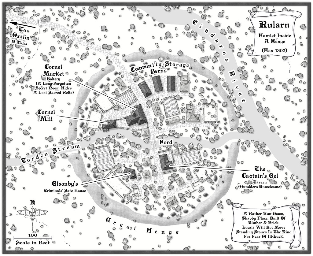
A more extensive set of notes than usual have been added to my WIP topic elsewhere on the Forum (as I remembered to make some screenshot versions as I was constructing this one!), with a higher-res image in my Gallery. The FCW and PDF notes files follow:

