


Wyvern
Wyvern
About
- Username
- Wyvern
- Joined
- Visits
- 3,266
- Last Active
- Roles
- Member
- Points
- 5,584
- Rank
- Cartographer
- Badges
- 24
Latest Images


-
how do I set up two floors when both have the same footprint?
If all you need initially is for all the walls to be identical for both floors, just copy and paste the walls of your first floor's drawing to wherever you need them, using |CC2COPY| .
If the doors and windows aren't the same on both levels, do this before you add any doors or windows.
If both levels will be in the same map, you can just use the straight copy command. If you're setting up two completely different maps, one for each level, then use the "Copy to clipboard" option instead, because the basic copy commands won't copy the selected items to be pasted in a different file.

-
Live Mapping: New City Style Part 4
Not sure if something (else...) has changed about the YouTube interface lately, but this isn't the first stream I've landed on recently where the timing hasn't been what was intended by the creator. In one case, even the DAY was wrong, so at least this was only half an hour out!
-
Don't know what projection this is
After a fair bit of digging around online regarding the game this originated with (Living Steel, by Leading Edge Games, from 1987), so far as I can tell, the planet Rhand was intended to be a planet much like Earth - so NOT a cylinder!
The original version of the Rhand map seems to have been done as a fold-out poster for the 1987 boxed set, and was a much simpler-drawn version than this artistic presentation. That map had two separate rectangles (for the east and west "hemispheres", probably centred on the equator, although no latitude lines were shown, only longitudes), and two separate polar circles. This colour-artwork version was included in a later single-volume work called Rhand 2349 in 1991 (see the RPGGeek page for it). You can see both maps together for easy comparison on the Wayne's Books blog posting here by scrolling down to the "Poster Map" section, about halfway down the page.
The map illustrated above seems to have been an attempt to combine these four original planetary sub-maps into one, so as J Slayton already ably noted, it's not any kind of real map projection at all, simply an artistic view of the planet. Sort-of. By the looks, the scale bar was simply copied and pasted from the map on the poster, and should probably be ignored for this map, as it has no actual meaning here.
-
Why is the default Fenlon scale so different to the original maps?
Incidentally, I discovered while investigating this issue (albeit somewhat after the fact), that one of the three sample maps in the Annual folder for the Pete Fenlon Revisited style is blank, the CA179_SilverMountains.FCW one. This may have been updated by a later version, as mine is from November 1st, 2021, but thought it might be worth mentioning in case it still hasn't been amended. It obviously isn't meant to be from the PNG image for the same map shows!
-
Lovecraft's Providence
Thanks Frosty!
There are some astonishingly detailed maps available online now. I found many for Providence alone from the late 19th and first half of the 20th century, and I know there are more for a lot of other places as well, including larger geographic areas. Some of the cartography on these is especially beautifully-done, something that has been commented on the Forum previously, of course.
-
Sinister Sewers - Style Development Thread (CA207)
Delightful! 🌈💩

-
Annual 2024?
My email about this arrived around 6½ hours ago now. Resubbed already, naturally!

-
Castle in a Cloud
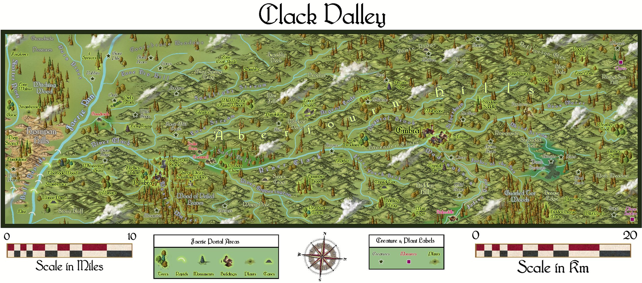
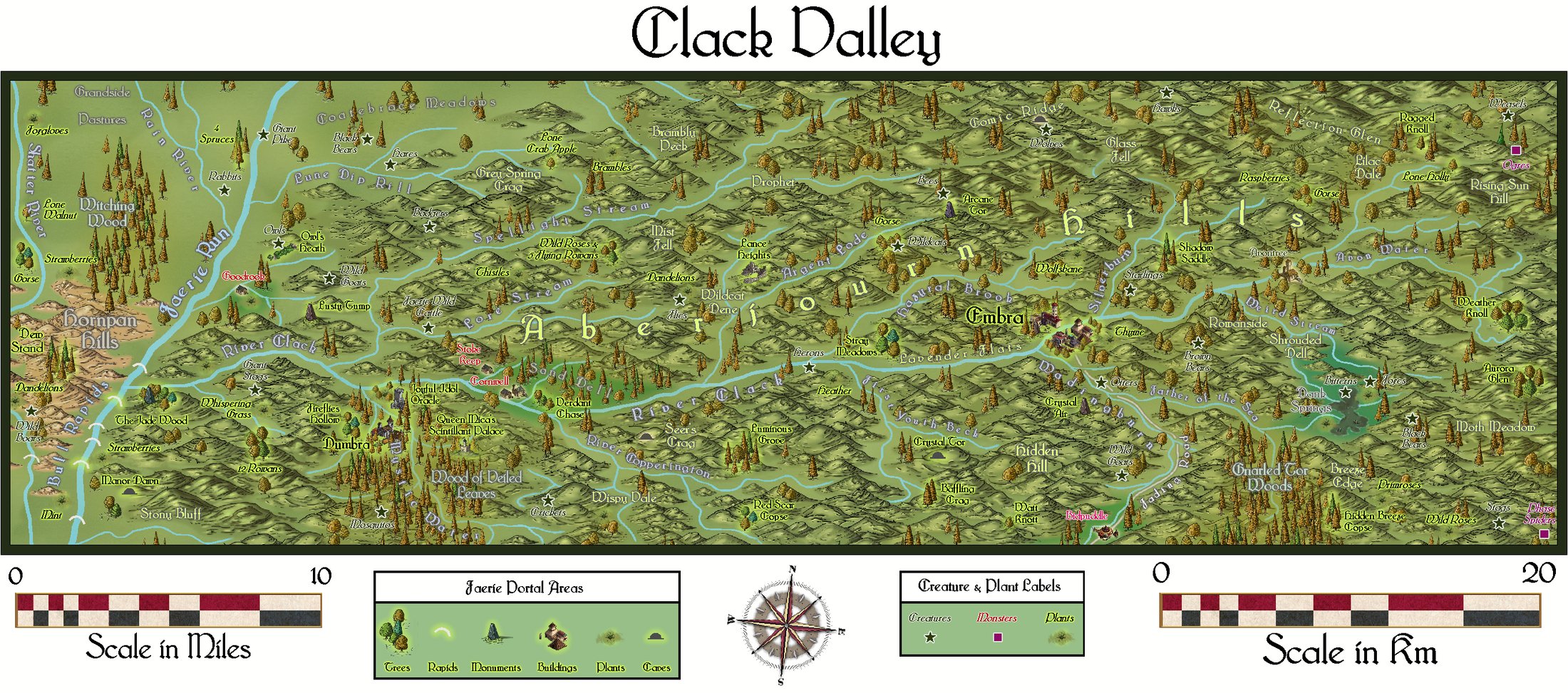
That's a good point Jim about your maps using the Alyssa Faden clouds. Reminded me I did one myself! It's the Clack Valley area in Alarius for the Community Atlas. This is the version showing the clouds in my Gallery, while this is the version without clouds so you can compare, although the map's colouring makes it difficult to spot the shadows as well (which tend to be quite close to the clouds, towards the right).
-
Shout Out to Ralf
You'll find there's a lot of catching-up to do, I suspect, so good luck with that!
With the poll, I've never constructed actual languages for RPGs/mapping, though I've used bits of those others have done (or adapted them; Tolkien's the obvious, though not the only, one). What I have done more frequently is generate random names from tables, and then adapt those, tweaking the spelling/pronunciation quite often, and then giving the names a supposed meaning sometimes. Or sometimes just making up interesting-sounding words.
As for the Annuals, while I have all of them, I've used only a fraction of them for actual mapping so far, though I do try to go with new styles when I'm doing maps for the Community Atlas especially. I agree with Sue though, that they all have their uses under different conditions and settings, and deciding which one(s) to use for each specific map is an interesting challenge in itself. Not found one I deliberately keep going back to repeatedly, as I'm always a bit concerned I'll get stale doing that (likely that's just me though😉!).

-
OSR Dungeon Tiles - Quick Test
Glad you'd got it sorted now!

