


Wyvern
Wyvern
About
- Username
- Wyvern
- Joined
- Visits
- 3,266
- Last Active
- Roles
- Member
- Points
- 5,585
- Rank
- Cartographer
- Badges
- 24
Latest Images


-
Winter Village style development (March 2022 CA issue)
And now released into the wild! Wrap up warm and go exploring folks!⛷️❄️☃️

-
Hunter's Home
Nice little shack!
It looks as if you may have a corner-join issue (SW corner). That could be because you started drawing the walls at the corner. If so, you might instead try starting partway along one of the flat sides, as if you start at a corner and then add a break in the wall - such as for the door - you can end up with this odd-looking effect otherwise.
And maybe add a window?

-
Inn of the Welcome Wench
The original T1 Hommlet mapper was almost certainly David C Sutherland III (1949-2005) as the credits in the original module were "Art & Maps: Dave Trampier & Dave Sutherland". David A Trampier (1954-2014), a somewhat tragic figure from the Wikipedia biography, seems to have mostly prepared lots of artwork - such as the original "orange" cover for T1, and the cover for the 1978 "AD&D Player's Handbook", for instance, often prominently signing his work "DAT". Amongst numerous other items, David Sutherland though famously produced the isometric maps of the eponymous castle for the original Ravenloft module (1983), which seems a good fit for the isometric Welcome Wench plans to my eye at least!

-
Testing some anti-spam features
Haven't needed to post elsewhere today as yet, so we'll see how this one goes.
I did find an oddity on the latest "Necro" thread re Cosmographer (Traveller Satellite Size <7) where I lost the vertical scroll-bar, and had to mouse-wheel scroll down to where the new posting was. Partway through doing that though, the scroll-bar reappeared. The other pages with new additions seemed to be fine for this, however.
Also, have you shortened the list of topics shown on the main "Discussions" page? It only covers nine topics now, as well as the five "Announcements" at the top (on the first page only). While that's OK today, there are days when the list of topics added, or added to, since my previous visit almost filled the old-style Discussions page where you could scroll down the list several times. That's going to get tedious very quickly if the number of "new" posts starts running to several pages, especially as I try to read them in order from oldest to newest. It's also going to make it much easier to miss posts by forgetting to check to other pages.

-
Weird blocks/kinks when drawing segmented lines
It may not help in this case, but if you haven't seen it already, you may find it worthwhile to check out part of one of Remy Monsen's video mapping streams, where he addressed the issue of dashed lines not retaining their appearance if you zoom in or out to them, and how the dashes can be made to have a fixed length appearance. The relevant section begins about 32 minutes in: https://www.youtube.com/watch?v=npHHQ6vcMHU .

-
Live Mapping: Fantasy Cities (Annual Vol 3)
And will Asa be appearing on-screen by macro-magic like Remy's Jack last week? 😉😼
-
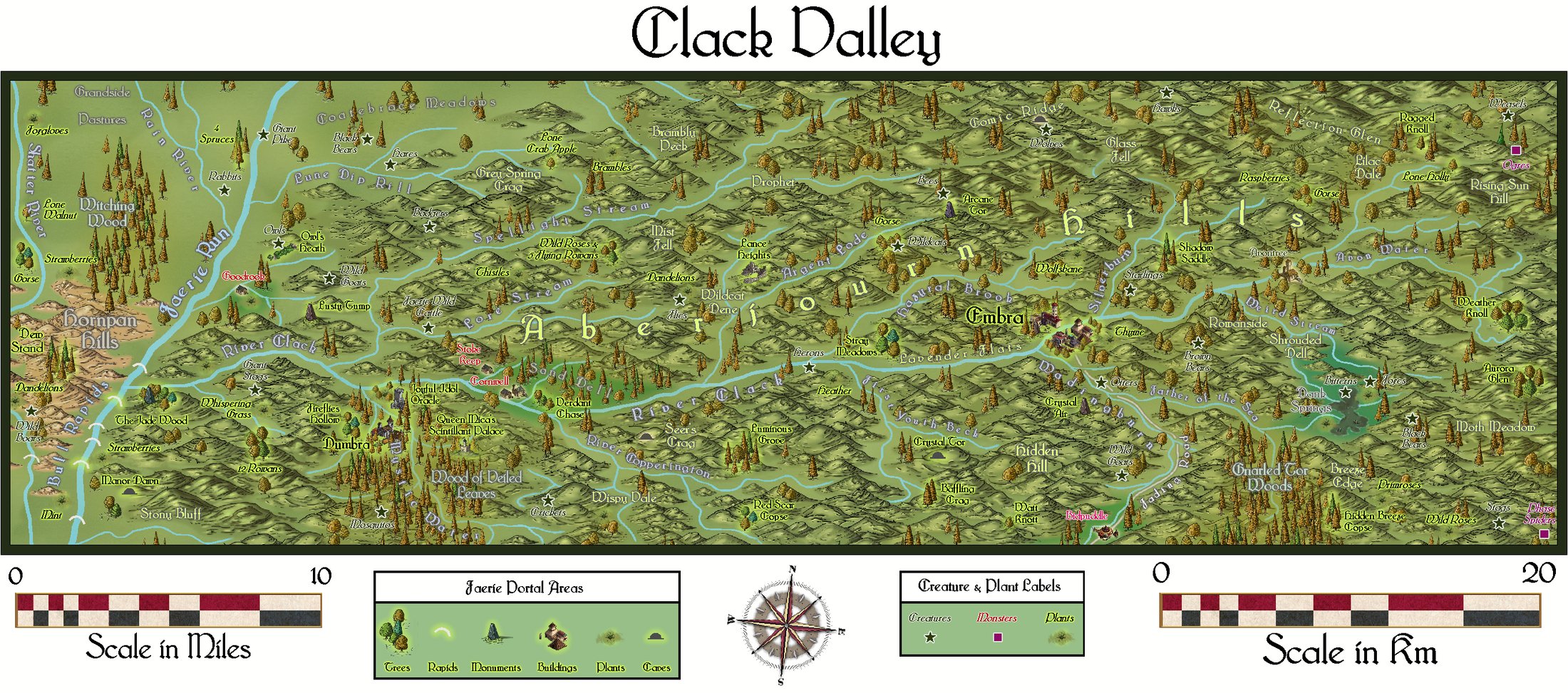
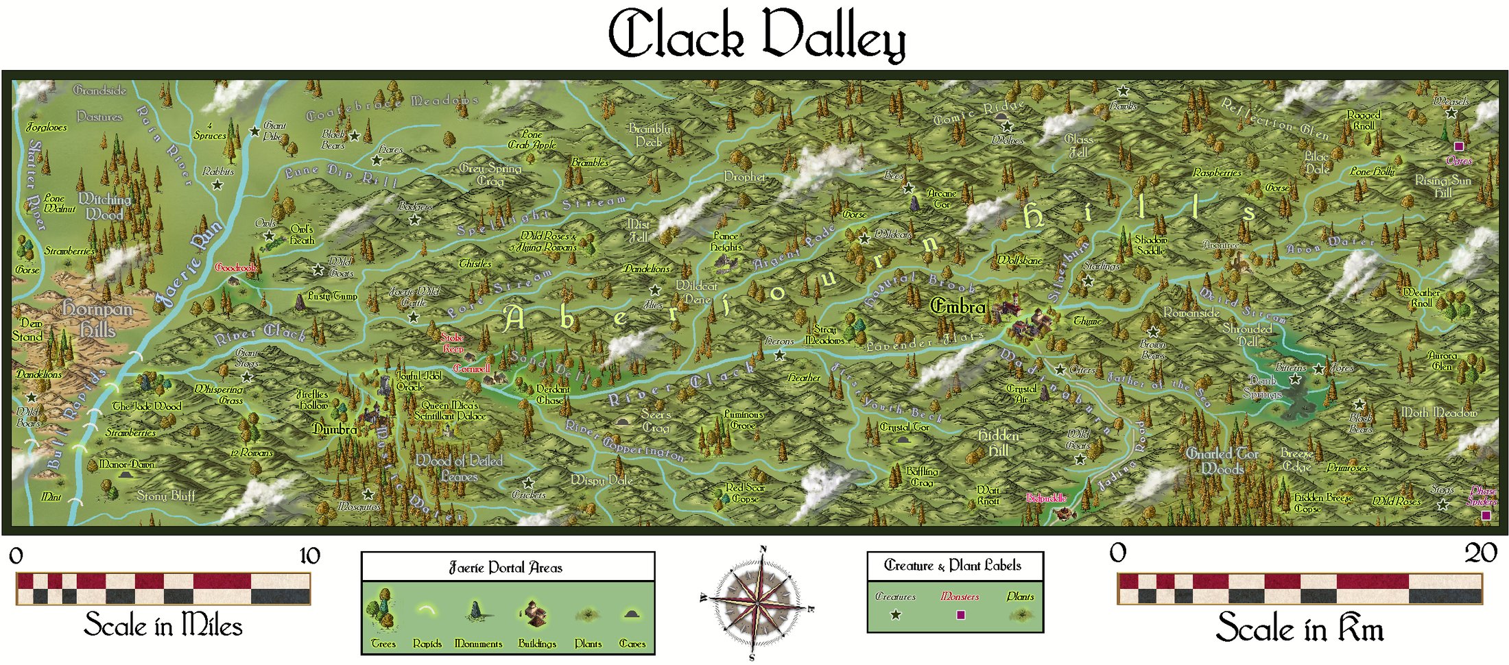
Community Atlas: Errynor Map 40 - Clack Valley
Thanks very much Sue!
Managed to upload a couple of higher-res images to my Gallery now as well:
-
Magic Mushrooms Valley
And the cattle and horses there are always happy... 🍄

-
smooth path mistery
Yes, the Text Along A Curve issue still remains problematical since it was changed a while ago. This topic covers up to where we are currently still, as far as I'm aware (which means Monsen's advice is what you should always do as standard now - uncheck the boxes - to get the command to work).
-
Richard Baker's World Builder's Guide Map Templates
After a fair amount of online hunting, I've drawn a blank over any electronic templates for this book at all, assuming this (DTRPG link) is the World Builder's Guide this topic refers to. What I can trace of Richard Baker's blogs online don't seem to go back far enough to cover the period this text was published (1996), but as he's still active online now, you may be able to find links on his blog somewhere (if this was something personal he put out, say), or at least make direct contact with him that way to ask. He's easy enough to find online, so I've not added links for the currently-active blog here.
If the templates were something that was on his older Wizards of the Coast blog, I think that has all gone - at least none of the links I can find to it seem to work any more. If you have an actual URL, you might try the Wayback Machine archive site, in case it's preserved there though.
Of course, if the electronic CC templates were created and made available by someone else, that may be more problematic to find.
