


Wyvern
Wyvern
About
- Username
- Wyvern
- Joined
- Visits
- 3,238
- Last Active
- Roles
- Member
- Points
- 5,517
- Rank
- Cartographer
- Badges
- 24
Latest Images


-
Community Atlas: Aenos Isle North, Demosthenes Swamp, Artemisia
Threshorsh promised to be an interesting challenge, as the dice designs for it had two subterranean segments linked by a surface area with a small settlement in it, so a mixture of different, though matching, mapping styles seemed like a good idea. In the end, that mixture kept getting broader as the mapping proceeded. This is the final map:
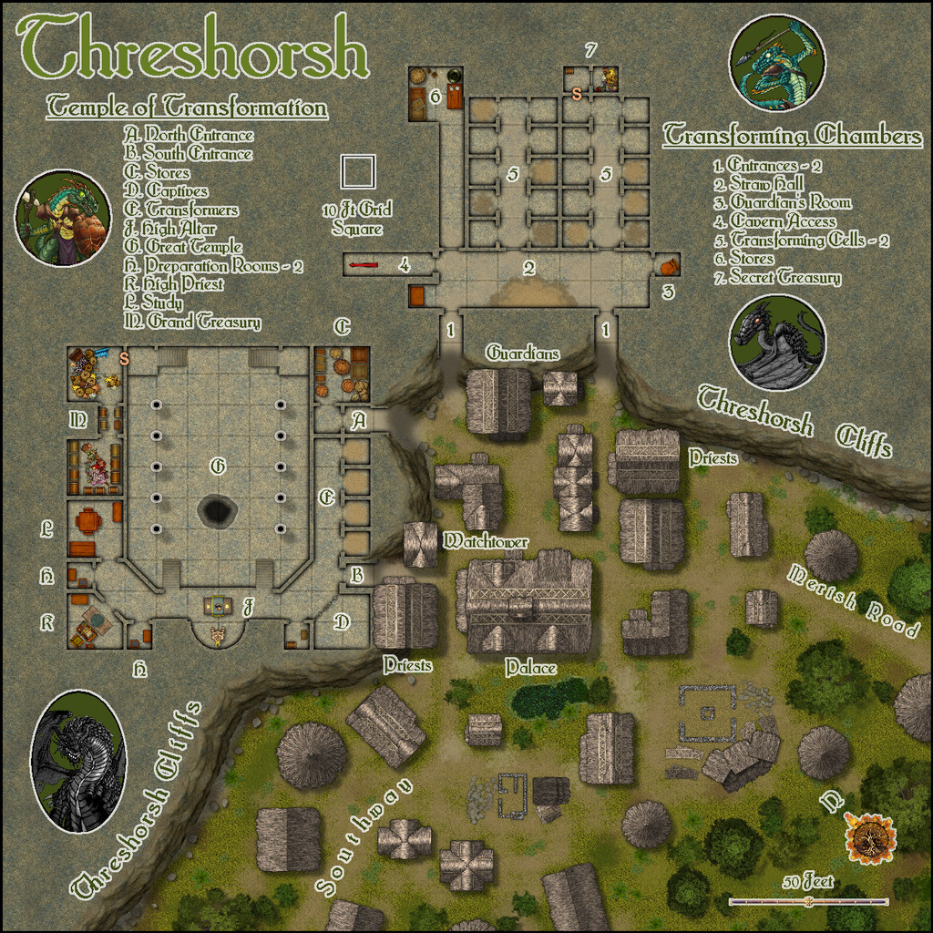
As the cliff line was such a significant feature on the dice designs, and divided the over- from the underground, I decided to start with that, and the overground segment of the drawing, thus started the map from Sue's Forest Trail and Forest Graveyard packs from the 2022 Annual. Of course, I knew already I'd be needing some buildings as well, and while I toyed with the idea of drawing just the interiors, as is often suggested with the "Dungeon" style packs, the dice showed purely roofed structures, which seemed a more interesting option here. So Darklands City from the 2021 Annual was quickly added to the plan, with repurposed ruins to show the stone foundations for structures still being built (as something the random options had come up with). One downside is the thatched Darklands City buildings all have obvious chimneys, so ideas were swiftly added for how to conceal those (tropics, after all). Luckily, the style has options for adding separate dormers and awnings, which helped greatly, and those features allowed the construction of additional building shapes as well - including what I really wanted to add beyond the area the dice design provided, some round hut shapes. And yes, those are hand-crafted from the resized smallest awning piece - hand crafted to help give a slightly more ragged outer edge, as these are huts built by Lizardfolk, after all!
The cliffs are meant to be fairly low, at most 60 to 70 feet, 18 to 20 metres - hence some of the properties built into the outer edge of them actually ARE meant to rise above their tops. That meant adjusting some of the usual options for the cliff effects (mostly on the hand-drawn shadows, which were also shortened). The Forest style allowed some playing around with the water effects as well, as while I didn't want to add a stream, because this is meant as the drier part of the Isle, I did want a freshwater source, and a rainfall pond seemed suitable. That proved particularly interesting, as I'd not used the technique for water employed here before. Chances are you may not be able to tell where it is at this resolution, but the pond lies just southwest of the Palace.
With the subterranea, the drawing was much easier, as neatly regular for the most part. I decided these areas were probably Dwarf or Gnome work, and likely commissioned long ago, perhaps by the Lizardfolk, to help account for their different appearance to the settlement (as mentioned in the notes to go with the map in the Atlas version). The chief concept behind the whole is that this is where Lizardfolk come from all across the - as the locals call it - Leminish swampland when it's time for them to begin their transformation to become Swamp Dragons. At Threshorsh, they can enter their chrysalis state during a ceremony in the Great Temple, then be taken to relative safety to continue their change in the Transforming Chambers, and returned for a further ceremony in the Temple as they begin to emerge. Following that, when they can move about unaided, the young Swamp Dragons are guided down to Thalagos Cavern, partly beneath the Temple via the Cavern Access passageway from the Chambers, where they can grow to a fuller strength and size before venturing out into the wilds. The timescales for all these changes should be highly variable between individuals I felt, and also that only relatively few Lizardfolk would ever undergo the change at all. The swamplands may be fairly vast, but dragons need a lot of land to support them, although I had opted for a more sinuous, serpentine form for these Swamp Dragons (largely influenced by the same-name dragons in the Shadowdark RPG, except those are flightless, whereas I wanted these versions to be able to fly, though not strongly or for long). This also allows for the fact that the Queen here, Shemenshra, is still in her humanoid form, despite having reigned for 40 years, for instance. In the notes, I did keep things vague as to how the Dragons may relate to their former selves and those they knew who remain as humanoids, or what mental abilities they may retain as Dragons.
Those familiar will doubtless have spotted that DD3 was called into action to expand the symbol options, and Creepy Crypts too, largely for its extra terrain patches, which are really helpful in blending and lightly altering the textures and transitions, along with providing straw piles for the chrysalises to rest upon. The straw colour in the Transforming Cells helps identify how advanced the progression may be for the chrysalis-occupied Cells (darker straw = longer time underway). Having allowed space for the map legends around all this still left some blank spaces, so finally TT1 was drawn upon for those figurative illustrations.
Next time, we find what lies beneath that irregular pit hole in the Great Temple (which probably took longer to draw to look right than the Lizardfolk spent cutting it through the rock, or that's how it started to seem...).


-
How can I make my grid overlay black on some backgrounds and white on others?
You may find too that increasing the line thickness of the grid may help, regardless of what colour you choose for it. The automatic grid creates zero-width lines, which can simply vanish at some image output resolutions.
You also don't have to create a single grid across the entire map. As long as you use the same snap grid point to start your grid's placement, you can have several smaller grids wherever you choose, and they'll all line up OK. That way, you can have different coloured grids on the same sheet (though of course, that may not work for all, dependent on what effects you have on that sheet). Or you can set them up on different sheets to get different effects per grid colour.
-
Community Atlas: Aenos Isle North, Demosthenes Swamp, Artemisia
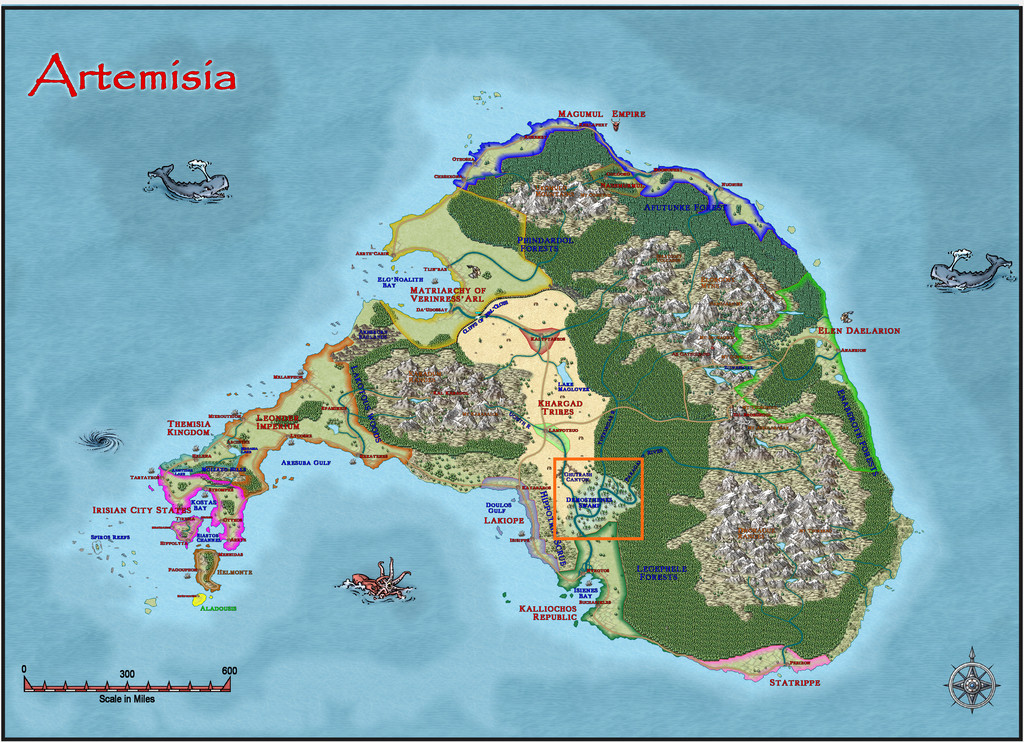
As noted when I was leaving the frozen wastes around Seer's Hall in Ezrute last time, I was heading off to somewhere warmer, in the tropics of Artemisia, in fact, around 25°N latitude, the heart of the Demosthenes Swamp no less:
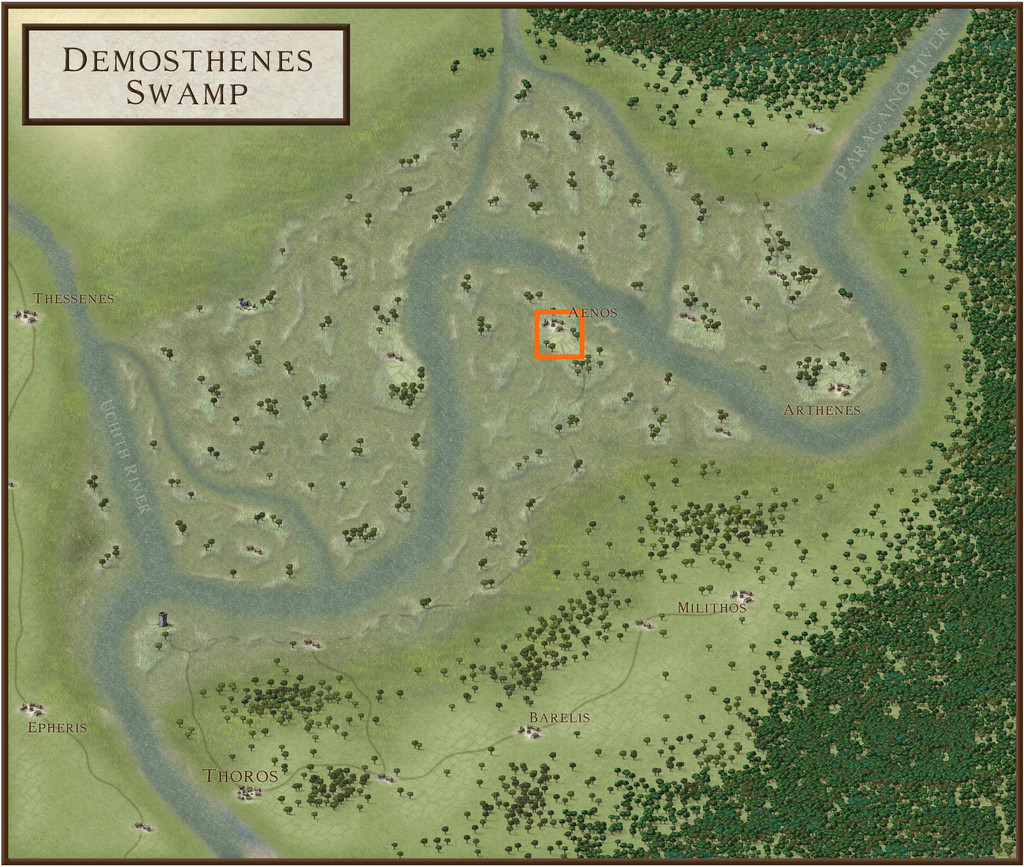
A further change was that this map was to be based on three of the Inkwell Ideas Dungeonmorph Dice designs from the "Adventurer" set, the first from that set I'd be using in this sort-of Dungeon24 (now of course Dungeon25...) project. I'd decided in advance to swap back to colour mapping from the black-and-white styles I'd been using for some months, and also to try out some different random design systems for determining what was to be where among these new maps. This time, I opted for a couple of weighty tomes by Raging Swan Press, delighting in the titles of "Dread Thingonomicon" and "Dread Laironomicon".
Looking over the map notes for the Demosthenes Swamp region, I found the area to be home to Lizardfolk living in smaller settlements, ruled over by a Queen. Quite quickly, a couple of settlement markers in likely spots towards the middle of the swampy region that would work with what the dice had provided became apparent - a surface settlement leading into two separate underground areas, with some of the surface buildings constructed against a right-angled cliff line. The Lizardfolk here were further noted as being the larval stage of dragons (which immediately, and quite naturally, became Swamp Dragons in my mind), the Folk passing through a chrysalis stage to achieve full dragonhood. With what the dice showed, ideas formed rapidly from this framework of notes, and I decided (for reasons that will eventually become clear) that I needed an additional, deeper subterranean map as well. That was determined from a couple of Inkwell dice in the "Lairs" set that showed interesting cavern options, and which weren't already going to be used for later maps in this series.
The site I chose was the settlement marked as "Aenos" on a small island in the near-central swamps, for which I also realised that, much as normal, I'd need a suitable area map. The orange square on this version of the extant Demosthenes Swamp map shows that area, which is 10 miles square:
Setting-up a one-mile square grid over this area, random features were allocated, besides what the parent Swamp map already indicated, again much as normal now. I wanted to try to stick with a similar "green" colour palette to the Swamp map, and soon realised that it would be possible to make use of some of Sue Daniel's Annual styles that fitted together to cover everything I'd need in this three-map group. It occurred to me early on too that as the Lizardfolk had a very different civilisation here to many of the other realms on Artemisia, it would be unlikely they'd persist in using the Greek-style names so frequent over the nearby area. So for a couple of major features - including the settlement, which had now become the Lizardfolk capital - I decided to retain the Greek names, and add local ones, while holding with local names for other places, or simpler descriptive names in English for the sake of clarity.
Since the area map was linked to the Demosthenes Swamp map, it seemed reasonable to retain the Greek-like name in its title, thus it became "Aenos Isle North", as covering more or less just the northern half of the Isle the settlement is set on. For the mapping style, I picked Darklands from the May 2021 Annual:
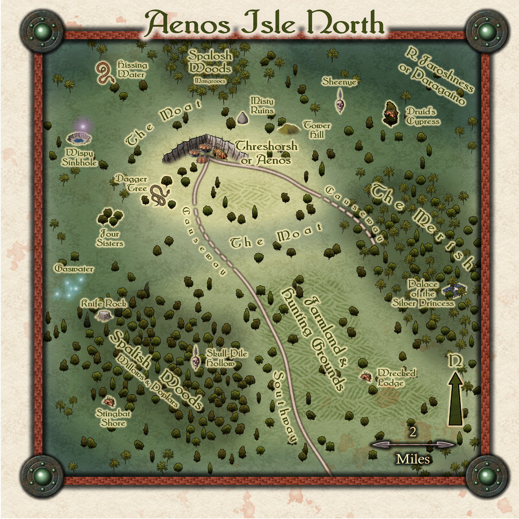
In general, I retained something akin to the colour scheme from the larger Swamp map, as that helped indicate where the higher, drier ground was, as well as the swampier areas, and the deeper swamps together with the great river that wends sluggishly through these. As normal, there are descriptive texts to accompany the Atlas version of this, but some further notes follow here too.
There seemed little point in trying to illustrate the numerous pools, ponds and streams across even this little zone, as in swamps, these rarely stay the same for long anyway. Looking at the larger map, the river channel - the Paragaino there, the Faroshness here - was shown as about five miles wide, although its indistinct edges create much doubt, just as would be the case in an actual vast swampland like this. So I took it there would be both identifiable rivers channels of varying width, interspersed with pools and marshes of varying depth and difficulty to cross, and which soon became the standard concept across most other places not on the Isle itself.
The woods were then allocated tree types based on the relative depth of swamp nearer to them. These were all assumed to be local tropical varieties, retaining more recognisable names again mainly for clarity. While the larger map does show farmland along the spine of the Isle, again that seemed plausibly more an external imposition by the local Greek-style map-makers, than reflecting the reality of what a Lizardfolk civilisation might have. However, some farming for food and building materials (timber, rushes, reeds) made sense, with a lot more of the drier ground left open for hunting. A random option allowed the inclusion in the text of some ant-nest "towers" here too, that outsiders might mistake for ruins...
I also decided against adding more settlement markers, given the capital of Threshorsh (as Aenos became for the locals) is only village-sized anyway. There is an assumption in the notes that there will be huts, farmsteads and hunting lodges scattered over the drier parts in general, which things like the Wrecked Lodge, Misty Ruins and Tower Hill further hint at/act as reminders. Not to mention the shunned Palace of the Silver Princess (a ruin guarded by a living, solid silver statue of a Lizardfolk Princess; and something else...).
The Moat actually isn't one, but a natural ring of shallower swampy ground that surrounds the highest part of the Isle, while the two Causeways over it also really aren't, instead being ramshackle sort-of bridges, made from tangles of living trees, dead logs and waterlogged old planks, suitable for foot traffic only - with difficulty. Southway was luckier, as it was given the randomly-selected option of running along a slightly elevated ridge, so is a more typical trail.
Happily, the style's cliff options allowed me to create the right-angled setting for Threshorsh the dice designs required, making a rather fun little arrowhead too. I almost thought to use this as the north pointer, although the finally-chosen arrow for that had to be ported-in from another of Sue's Annual styles, Creepy Crypts from 2022, largely because I'd repurposed the skull-and-spear north pointer from Darklands as a marker icon for a couple of mapped sites by then, one for the Banshee Sheenye, the other, at Skull-Pile Hollow, as a former Green Hag's lair-marker. Indeed, that latter, with elements from both Knife Rock and Stingbat Shore - all decided randomly don't forget - helped characterise Spalish Woods as somewhere the locals try to avoid. The Hag is dead. Probably...
Next time, we get up close to Threshorsh.


-
Birdseye Continental - style development thread
Yes, that's it Sue. It helps make the water texture look more like broad-scale ocean waves, and the land textures more like the smaller-scale surface undulations you find there, at least to my eye/mind.
[Now just wait for the chorus of disapproval from everyone else 😉]

-
Egyptian Resources?
Not sure if there may be something like this among the free icon resources listed here, though I don't recall an actual Egyptian burial barge from them offhand (I'm not especially familiar with all these options, however).
There is though a specific top-down, ancient Egyptian barge symbol in this paid-for icon pack from Inkwell Ideas, amongst other items. You'll need to convert the PNG artwork from that to symbols you can use in CC3+, if you need the items as symbols, but that's pretty straightforward.


