

Using Watabou generators to creat a campaign.
![[Deleted User]](https://secure.gravatar.com/avatar/c75d9a245b74d9c59be0999ea81ca541/?default=https%3A%2F%2Fvanillicon.com%2F92add7f8c954488718110edc4896ad39_200.png&rating=g&size=200)
You all know I love the Watabou generators. He now has a good overland map generator, city and village generators and building and dungeon generators.
So just for fun, I decided to map these generated maps - island, city, building and dungeon.
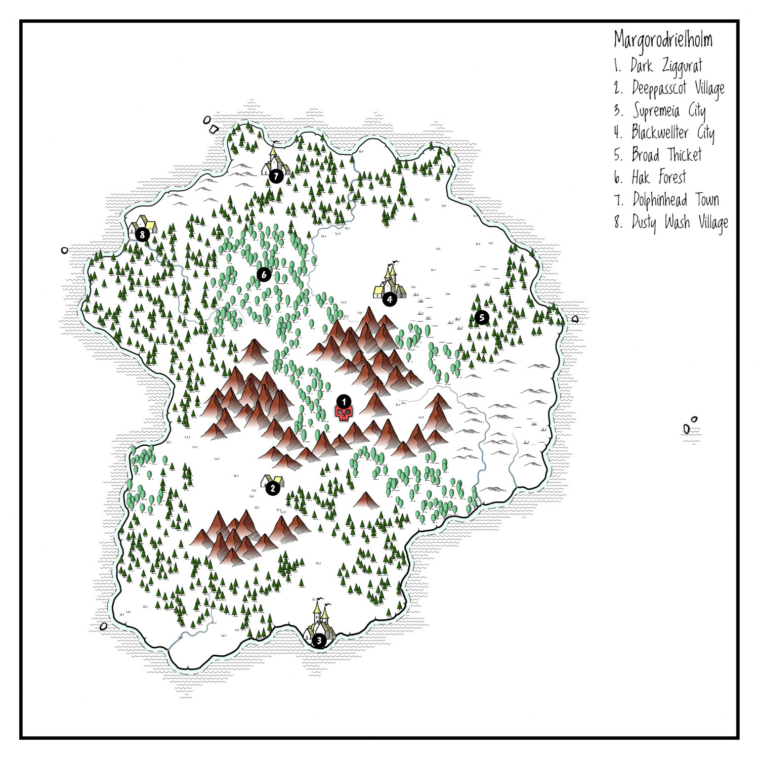
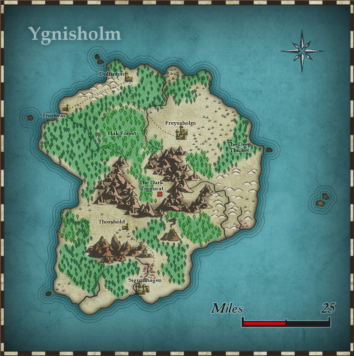
Here is the island of Ygnisholm. Worlds of Wonder style.
Comments
Here is the city of Sigurdhagen (the Watabou generated map I turned upside down to fit in the map above. Done using the Watabou style.
Here is the building - a simple 2 storey building. There is a Print Screen version of it in 3d (the back of the building labelled as 1 in the environs map - you can work out which one by the shape). I used the Moody Mansions style (the first time for me).
2nd level completed.
Finally, the hideout for Mr Dagmar and his criminal mates. And unknown to them, an ancient evil lurks beyond secret and trapped doors. Done using the B&W dungeon style. Another first for me.
The two sigils are also from Watabou - the Sigil generator. I have turned them into symbols - vector, variable colour.
Well, that's just awesome, Quenten! Great work!
Thanks for that. It sure makes mapping heaps easier.
Very nice work there Quenten.
Based on the direction of the river, it does look that the Sigurdhagen map should have been flipped along the horizontal axis insted of being rotated 180 degrees.
It would probably have worked OK too if rotated 270°, so if the Sigurdhaven map was rotated another 90°, it too would be OK (or just turn the compass rose to point to the left edge as north, instead of the top one). And then amend the compass pointer on the first Dagmar's map, of course...
I can always fix the river - haha. Thanks for spotting. I didn't take that long to do these maps. not like my usual tortoise like progress.
ABSOLUTELY AWESOME!
You've inspired me to use these styles. Thanks so much!
Cal
I have added the second floor of the Gaming House, and minor correction to the map, and ground level of the gaming house.
I will also do a lower 'dungeon floor in the Egyptian style, based on another generated Watabou dungeon. As well I will also use the village generator to create a small village. That will do it, and all Watabou's generators will be presented.
Oh, and the locals dug out a new channel for the river (see main map).
I will try to add all these, bar the main map, into the Atlas (as well as my own world).
The generated Watabou tomb. Let's see how I go. I am again using this style (Ancient Tombs) for the first time.
First - the map as the player sees it:
Now as the DM knows it is:
I have made some minor modifications to the generated map.
I MAY get around to trying my hand at the 3D version. (Not only have I not mapped in the Ancient Tombs 3D style, I have never done perspective maps at all...yet).
These are the "Alice" versions of the Egyptian tomb style, I see (Looking Glass) 😵😉
And maybe the player's version shouldn't have the full key listing?
Bit nitpicky here, but it looks like the players version have been hidden by simply overlaying a polygon on top of things, I can still see some floor edges there.
I would suggest using separate layers that can be toggled to completely remove the entites, and possibly draw in a full wall on the player layer as well instead of the thinner one. I have a blog article on this.
I'm a huge fan of the Watabou tools as well, Quenten, but I've never tied them all together with CC3+ this way. You did an amazing job with these! I especially like your city map. You've really inspired me to lean more on Watabou for an upcoming adventure in my campaign.
Cheers,
~Dogtag
Yea, this particular article was written with the intent to hide things that are "outside" the structure.
When it comes to your house, that's a very tricky thing if you let the players have access to the entire map, as that clearly allows them a different view than a person there would have, and instantly reveals things like too-thick walls or suspicious corner. I would be tempted to give the players a modified version of the floor-plan, where the rooms are slightly larger, maybe the house slightly narrower to hide such thick walls. Only if they actually start measuring things should they be given the true map so they can see that there is something wrong here....
Of course, some players may call foul on such an approach, feeling mislead. And it also means preparing two maps instead of simply hiding something.
For reasons like this, I usually never let the players see the entire dungeon. I practice hiding everything they can't currently see. (Using MapTool hooked up to a projector)
I have fixed the Tomb maps, so one need hide or display the Gamemaster only layer to get the required changes.
Here is the village generated by Watabou. For this map (mainly Ryecroft Town style, which again is new to me), I have also used the fields from Fantasy Town annual.
And this completes the generators and maps derived from them. The CC3+ maps took hardly any time at all - only 1 (the Tomb) took over 1 hour, and that was mainly working out how to do a Player's map and Game-master's map with hiding or revealing 1 layer.
Might be good to have some hedge- or fence-lines round the fields.
Sure - will do. Got to keep those wallabies out.
Well, you can always tie me kangaroo down.
That's hardly sporting, Jim...
Its from an old song, about 1960.
by Rolf Harris.
[Spoken-word intro:]
There's an old Australian stockman lying, dying,
He gets himself up onto one elbow and he turns to his mates
Who are all gathered around and he says:
[Verse 1:]
Watch me wallabies feed, mate
Watch me wallabies feed
They're a dangerous breed, mate
So watch me wallabies feed
Altogether now!
[Chorus:]
Tie me kangaroo down, sport
Tie me kangaroo down
Tie me kangaroo down, sport
Tie me kangaroo down
There is more to it, I'll let you look up the rest.
It's by Rolf Harris, the paedophile who went to prison for his crimes. Aussies don't bother with his songs now.
Ah, didn't hear that in the states, just the song.
And the song was converted into, shall we say, more ribald lyrics in certain quarters even long before all that came to light...
No comment. I heard ribald songs in the US Navy... until an officer happened by and ordered my shipmates to not sing that.
Quenten,
I've tried for hours to get something like your Watabou map for a SVG to DXF conversion to use in my campaign and I can't get it to produce an image like you have there. Can advise?
thanks
Cal
@Calibre Which Watabou map are you referring to. I only use the conversion technique for cities - the rest I use as a png to copy from, since they have nowhere enough entities to be bothered about.
If it is cities, can I refer you to both Ralf's video tutorial as well as the instructions in the Annual issue.
Finally, here is a link to my long discussion about Watabou cities. I will be making a 'new' style based on this as my example for Annual 1, issue 12 video by Ralf a few weeks back.
Watabou Medieval Fantasy City generator — ProFantasy Community Forum
Thanks, Quenten
It's the cities. Ralf's vid and the map guide do not work as the options for Watabou site UI have changed. I have a post on here showing what it's looking like for me on Mapping forum.
Cal
Here: https://forum.profantasy.com/discussion/11616/mapping-with-watabou#latest
I will do a map step by step for the new UI.
Give me a few hours though.