

Ethran: Merelan City
 Loopysue
ProFantasy 🖼️ 41 images Cartographer
Loopysue
ProFantasy 🖼️ 41 images Cartographer
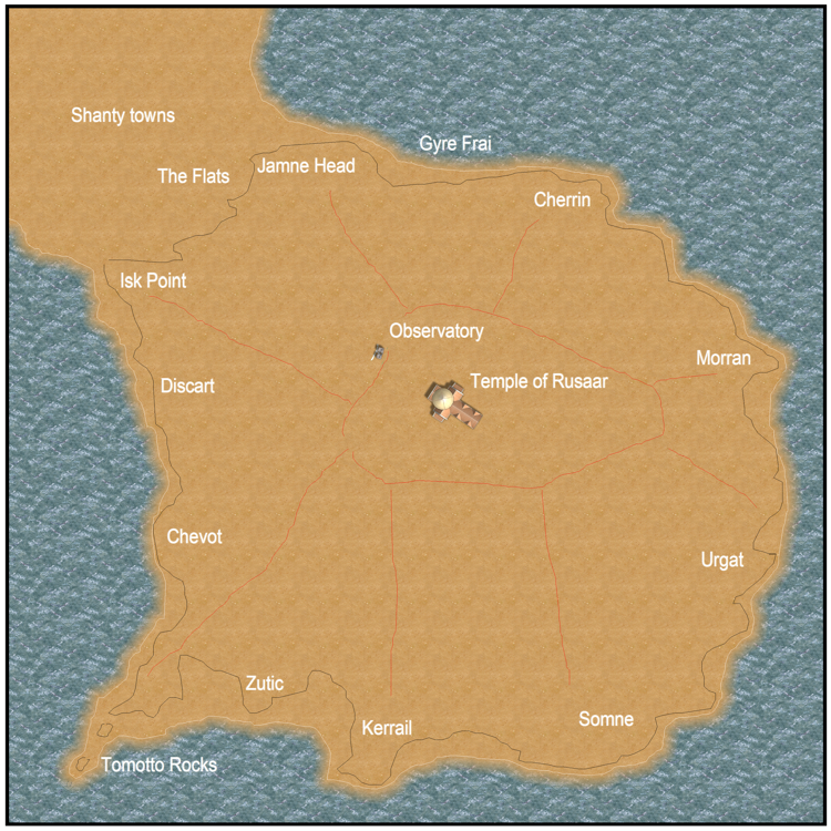
Merelan started out as a Merlish fishing village that was invaded by the Blucrans about five hundred years ago. The Blucrans discovered what they believed to be the sacred pool in which Rusaar spawned the life of their world near its peak, and they built the temple of Rusaar to protect it from the common hordes. The city grew in size owing to the steady flow of Ruzarian pilgrims, and the defeated Merles were pushed out towards the outskirts and around the harbour, where they continue to fish the surrounding ocean and feed the growing number of hungry mouths. More and more nowadays those mouths are driven to the city by hunger, not faith, since Ethran is in the grip of a deepening drought that seems to have no end.
There is a large fish market on the flats beneath the frowning cliffs on the north side of the island, and everywhere the homes of the people are snuck up against the cliff or borrowed into it for protection from the screamers - toothless pterodactylian predators capable of scooping up the unwary... to swallow them whole.
This initial sketch shows the extent of the temple grounds on the peak of the island, and the ridges radiating out from that peak. I have also sketched in the names of the regional parts of the city, and marked where the observatory is on the north side of the island's cap.
Comments
Though, personally, as an American, I say, "Tomayto Rocks."
Hm... maybe that's not so much "dinosaur" as it is "nerd." And, for the record, my smiley GIF also pre-dates smartphones, by years.
(Yeah, okay. It's "nerd.")
You haven't seen me do anything from scratch like this before. All my maps generally start with a blob thing LOL.
You guys are fun. Why make maps if its no fun?
This is not to say that the shape won't change after this, but just that its unlikely to go anywhere far from this:
Its no use. I've ben up all night working on this. I'm going to bed with my chips. Bye for now!
This is what I do when I'm not happy with an outline, and I haven't used Fractal Terrains to get myself a decent looking coastline to start with (not that I've made many maps before, but maps are not the only things I've ever made). I'm not sure what really is wrong with the shape, other than its just somehow a bit... "blocky".
Whatever it is that's actually wrong with it, I exported a bitmap of the landmass, then gave it a bit of twist and node warp until it looked about right (or at least a lot better). Since I'm using my own lingo here for things I do in CorelDraw, I've saved 4 versions of the file to show you what I mean, and pasted them in a vertical string so you can scroll down without having to go sideways as well.
You can go too far with this sort of thing, as you will see from the fourth and last image, which looks very obviously like a warped bitmap, rather than a possible land mass.
I have chosen the third variation to take forward. Now there will be a short break of maybe a day, while I import the bitmap back into CC3 and make a more careful and thought out tracing of the land mass.
The city of Merelan occupies the entire Island. I could very easily have just mapped the whole thing onto the initial blob map, but I thought it would look better if I paid more attention to the overall composition. (You can blame looking at all the countless thousands of different map styles on Cartographer's Guild for that idea)
This thread is a "this is how I did it from the bottom up" sort of thread - a bit like the ones that Ladiestorm is so good at doing.
In my imagination its a massive flat-topped and very irregular column of rock with a city built into the cliffs for protection, and the temple and observatory sat right on top. Whether I ever get it to look like that is another matter.
But I clearly need some practice at the presentation level! LOL
I have a suggestion, even at this very early stage
When there is a city on an island not far from the coast, it looks natural that the coast would have some settlements for people travelling to the city. At least some harbour, probably some kind of caravanserai, orchards, fields to feed the city (people cannot survive on fish only), maybe a bridge with some heavy protection... But with your current composition, there is not enough room to display anything on the coast.
And now a question: Is the observatory the same that you displayed in another thread?
All suggestions are welcome, and yours are certainly worth thinking about. I haven't really set the scene with this one too much, but I should probably do that now, so that you know where I'm coming from with this.
Merelan is built where it is because it is the site of the most holy place on Ethran - the Pool of Life, where Rusaar spawned the life of Ethran. This is still said to exist somewhere deep beneath the temple, which was built to protect the holy shrine. the shrine drew pilgrims and a community steadily grew up there, eventually becoming the City of Merelan. (
a bit like Jerusalem, or Mecca. There are two other really important reasons that Merelan is built on an island, and mostly into the cliffs at that. Its because the pterodactylian predators of Ethran fear water, and are too large to be agile enough to fly along a rugged cliff face and pick anyone off one of its inclines. (The temple and the observatory are protected... but that's part of the story and I would spoil it if I said too much about that).
There are fields on the mainland, or at least there used to be fields. Ethran is suffering atmospheric erosion by its larger twin planet, Errispa, and this is causing (among other things) frost on the ground in midsummer, freezing cold nights all year round, and an ever deepening drought as the weather systems begin to weaken and fail. Refugees from blighted lands flood into Blucrene - the last tract of habitable land on the planet, so we have a population v food crisis beginning to develop. Fortunately the end of the world has yet to affect the deeper water of the Iris Ocean around them, and fishing remains good. This diet is supplemented by edible sea weeds, and a sort of potato-come-carrot-come-cactus plant called parrac, which is the only thing that anyone can still grow in the desiccated mainland soils.
The ruling Blucran Sayers do not approve of the fish market that has developed on the Flats below the city, but they allow it to continue, or face the possibility that the "tramps and vagabonds" camping on the mainland shore might just storm the city wall and take their homes and their women.
...
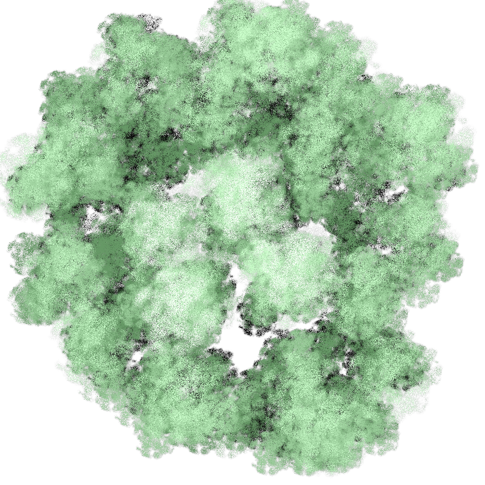
Yes, the observatory is Merelan Observatory, and now you are wondering why things look so green and flower all around the observatory
There is a spring in the Observatory garden, which for whatever reason has never run dry, even now. The lovely trees and flowers of Meloa's garden and the green grass around the observatory are some of the last living plants on Ethran, other than tumbleweed cactus and parrac. Of course, that far removed from the human suffering far below on the Flats, none of the observatory inhabitants ever really thinks that it might be nice to help out by growing parrac, and neither to the Sayers, who have done nothing to plough the gardens hidden by their temple wall.
Well. That was a bit long, but I hope it paints a more accurate picture of what's really going on with this map *)
O je, o je!