DaishoChikara
DaishoChikara
About
- Username
- DaishoChikara
- Joined
- Visits
- 125
- Last Active
- Roles
- Member
- Points
- 66
- Rank
- Traveler
- Badges
- 2
Latest Images
Reactions
-
Greetings
Welcome aboard!
Lots if “experienced” gamers here ;-)
as well as newer folks. This is a great place to share and learn!

-
CA style development - "Darklands City" (issues for September and December 2021)
Here’s my list in no particular order:
stables/corrals
mud, mud with straw
street tools with sewage channel down the middle
pillory/stocks
crow cages/gibbets
tannery
chimney smoke
foundry/forge
circling crows/vultures/pigeons
insect swarms (flies, roaches)
flames (for burning buildings or trash)
sawmill
grain silo and mill
watermill
(I’m sure I can think of more to add later)

-
How To Save Image Without White Box Surrounding It
Well, I’m glad to know I’m not crazy. I’m assuming this bug is so intractable that it can’t be fixed? Workarounds are nice and all…

-
Seeking advice re world map and civilization placement
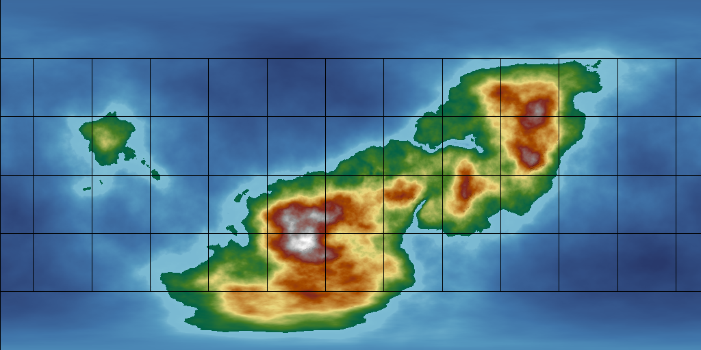
Good eyes Sue! Yes, that is your color scheme. I really like it for working on topography. I am indeed using the Prescale edit tools.
As for the formation, the shape of the continent was large generated by FT3 using the "fBm with Perlin's Improved Noise" fractal function, and then trimmed around the edges by me using the prescale edit tools. The only really intensive work I've done so far was to make the two inlets, and the large plane north of the "Mediterranean"-like inlet.
I was going for a near-pangea idea, where the large continent appeared to be in the beginning stages of breaking apart. I'm going for a very pre-historic look/feel for the world I'm designing. The two inlets are where I was mainly concerned about unnatural appearance as they're the most heavily-worked areas of the map, but I'm glad for the feedback on the overal shape/look of the map. Any advice further considering my design elements would be welcomed!
As for the mountain ranges, those are what the fractal function gave me. I'm not really sure how to use it to give more real-world looking mountain ranges, and every time I've attempted to use the prescale edit tools to change mountainous areas has resulted in tragedy.
Overall, I want an earth-sized world, but as it's for a tabletop rpg, the "action" will largely focus on a single small region. I just want a global map for my own purposes in case of further expansion.
-
Seeking advice re world map and civilization placement
I've been away for awhile, but wanting to get back to working on my D&D world.
Attached is my latest attempt at world mapping with FT3. Trying to learn more each time I mess with it. I would like advice on this map concerning the following:
Does anything look too unnatural? I edited the base map with some touches, trying to make land more on one side of the mountains than the other, as well as build up and eventually cut into the likely comfortable areas.
Where are the likeliest places that civilizations might develop? This is for a fantasy world involving humans originally, but where those humans have been transformed into humanoid creatures that are less temperature-sensitive, tempered by the fact that their leader creatures have preferential climates/zones, notably Desert, Forest, Mountain, Tundra, and Swamp.
Would this map produce the above-mentioned landform/climate zones mentioned above, spanning said range well enough?
I should specify, this world is based off the same size as earth, so this is one large-ish continent that spans almost the height of the globe.
Rambling aside, any feedback, advice, critique, or suggestions are welcome.