

Seeking advice re world map and civilization placement
 DaishoChikara
🖼️ 1 images Traveler
DaishoChikara
🖼️ 1 images Traveler
I've been away for awhile, but wanting to get back to working on my D&D world.
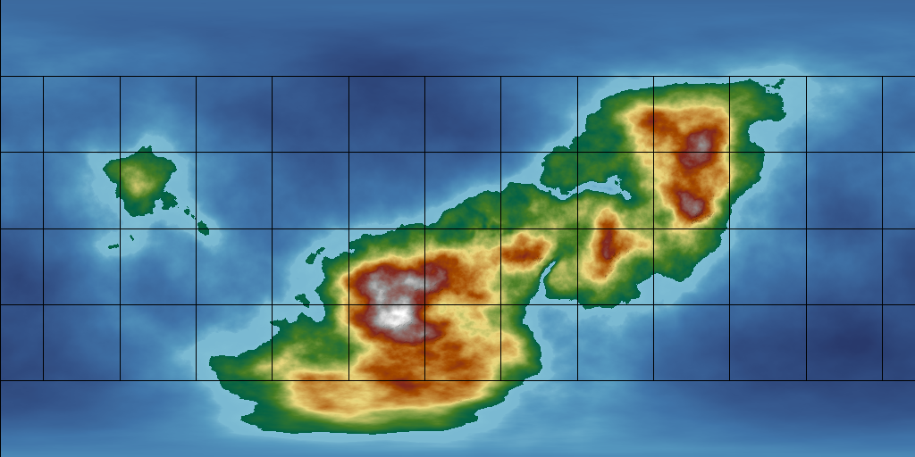
Attached is my latest attempt at world mapping with FT3. Trying to learn more each time I mess with it. I would like advice on this map concerning the following:
Does anything look too unnatural? I edited the base map with some touches, trying to make land more on one side of the mountains than the other, as well as build up and eventually cut into the likely comfortable areas.
Where are the likeliest places that civilizations might develop? This is for a fantasy world involving humans originally, but where those humans have been transformed into humanoid creatures that are less temperature-sensitive, tempered by the fact that their leader creatures have preferential climates/zones, notably Desert, Forest, Mountain, Tundra, and Swamp.
Would this map produce the above-mentioned landform/climate zones mentioned above, spanning said range well enough?
I should specify, this world is based off the same size as earth, so this is one large-ish continent that spans almost the height of the globe.
Rambling aside, any feedback, advice, critique, or suggestions are welcome.

Comments
Nothing looks unnatural to me, but I do not look at FT that often.
In terms of human civilization, water is the key. Flat land near rivers is the place where civilizations will start. River provides needed water to drink and for crops. Flat land permits growing crops easily. In terms of settlements, people are naturally drawn to the high ground. So, you might expect house to be built on a hill with farmland down below closer to the river.
Coastlines are also a place for settlements. Ideally the location will be where a river hits the ocean. Thus, you have fresh water and then the ocean. Coastline settlements are usually more important once you have boats. This permits trading and fishing.
Civilizations are likely to start north of the tropic of cancer. You want it warm and wet, but not jungle. Egypt, Greece, Babylonia, China are all above that Tropic. Ethyopia is just below it as well as India.
Based on that, I would say the bay north of the center line is the place most likely to have your first civilizations. Of course people walk everywhere prior to the first settlements, so humans will be dispersed. Eventually those people will create some type of permanent settlements. These will just be later. Further, they often develop based on trade routes.
I think it might be a bit too massive in nature.
You have two huge mountainous regions, the smallest of which is probably the size of Africa. You might want to have a look at just how many mountain ranges there are in the combined area of Earth's landmasses, and maybe rethink those bulky summits.
There's a map on this link that shows the mountainous areas of Earth in red. It's a bit psychedelic, but the colours are as close as I could find to the colour scheme you are using for your map. Remember that the ice caps on Greenland and Antarctica account for the red in those areas, and you will see that very little of the real world is actually mountain, and that those mountain ranges are much more linear in nature and relatively short (with the obvious exception of the Andes and Rockies).
I think its possible that the way to go from here is to worry first about breaking up those masses by levelling wide troughs through them so that they really do end up on one side of the continent or the other. That will automatically make your world look like it is much larger.
The easiest way to do that with least fuss is to activate the prescale offset editing, and use only the prescale raise and lower brushes (the green ones) set large and very low powered. These brushes cause less damage to the underlying fractal. I assume you have The One Day Worldbuilder, since I think that is one of the colour schemes that comes with CA155, so this is probably a repeat of information you already have ;)
I'd say a couple of things.
First, on mountain placement, I'd make narrower ranges. Mountain systems are generally no wider than 2000 km, though that means several actual ranges. Examples include the western United States and the Himalayas. You'll notice in both cases that there are ranges, plateau lands, and then more ranges. Another interesting example is South America, where the mountains are made up of three parallel ranges in some places, though the overall system is much narrower.
If you have access to it, the One-Day Wordbuilder from 2020's annual is a great way of dealing with mountain issues.
Second, I agree with Julian for the most part about civilization placement. On our world, the first civilizations all came about in the 30 - 35 degrees north range, and that had a lot to do with the recession of the ice age and the development of farming. Another thing to note is that contrary to what some folks think (and have published), cultures tend to arise in areas where there are different resources being exploited. This is because those areas become important nodes on pre-existing trade routes and tend to build up large populations. The result of this is you will often see "civilizations" (in anthropology we call them "complex civilizations") developing in areas with large variation in elevation. This is because different elevations create different micro-climates where different different resources can develop.
There's all sorts of exceptions, of course. For instance, the peoples of the Canadian west coast are now considered to have been a complex civilization, and their above the 49th parallel. Another intriguing example is central Europe, which seems to have been pretty well developed pretty early as well. Both of these examples involve the height variation I mentioned, along with very temperate weather at sea level.
Anyway, glad to use the archaeology education for something :).
The topographic advice here is good if you're aiming for a more-or-less duplicate Earth, as far as range and extent of terrains is concerned.
However, the nature of your initial map suggests that may not be what you'd prefer, so it might be interesting to consider the example of the planet Mars here too, as an alternative. The maximum range between the highest and lowest points on Earth (Everest to deepest ocean trenches) is almost 20 km. For Mars, a much smaller planet than Earth, it's 30 km. On Earth, as mentioned already, there are relatively scarcely any mountains, and no substantial clusters of them, when looked at on a global scale. On Mars, more or less the entire southern hemisphere is rugged to mountainous:
The image above is from Wikimedia Commons, though should you wish, you can find a little more on the topic, with referencing pointers, via the Geography of Mars Wikipedia page as a starting point.
As Sue said, it's less easy finding a decent comparison map for Earth, but this one's a reasonable rough comparison for the Mars one here at least, again via Wikimedia Commons, as found on the Wikipedia Global Relief Model page:
You pays your money and takes your choice!
And let's not forget, there's more than one hemisphere! People also live and thrive below the tropic of capricorn as well, Aboriginies, Aztecs, Myans to name a few...Give the south some love people!
I'm glad nothing looks too unnatural. That inlet between the equator and 30 degrees latitude was inspired by the Mediterranean Sea, although it's a bit south of where it would be on Earth. I figured the area surrounding that sea as well as to the equator and north in that wider plain would be my optimal placing.
Good eyes Sue! Yes, that is your color scheme. I really like it for working on topography. I am indeed using the Prescale edit tools.
As for the formation, the shape of the continent was large generated by FT3 using the "fBm with Perlin's Improved Noise" fractal function, and then trimmed around the edges by me using the prescale edit tools. The only really intensive work I've done so far was to make the two inlets, and the large plane north of the "Mediterranean"-like inlet.
I was going for a near-pangea idea, where the large continent appeared to be in the beginning stages of breaking apart. I'm going for a very pre-historic look/feel for the world I'm designing. The two inlets are where I was mainly concerned about unnatural appearance as they're the most heavily-worked areas of the map, but I'm glad for the feedback on the overal shape/look of the map. Any advice further considering my design elements would be welcomed!
As for the mountain ranges, those are what the fractal function gave me. I'm not really sure how to use it to give more real-world looking mountain ranges, and every time I've attempted to use the prescale edit tools to change mountainous areas has resulted in tragedy.
Overall, I want an earth-sized world, but as it's for a tabletop rpg, the "action" will largely focus on a single small region. I just want a global map for my own purposes in case of further expansion.
Thanks for the insights, as well as some name-dropped civs I can look up for personal reading/inspiration!
I do have the One Day Worldbuilder, and I have read and worked my way through it. Was very satisfied. I don't remember it saying anything specific about making narrower mountain ranges, but I'll re-read it again.
Thanks for the wiki pages to read! One of my favorite past-times! ;-)
I have been using size/elevation settings that are near-earth. Same earth size, same lighting/albedo/climate/etc, and with a -30000 to 30000 range in elevation. If you think I should change any of that, I'm all ears.
I fully intent to at some point. The map I was working on prior to this was almost all within the southern hemisphere, which made for some interesting cultural and geographical choices while worldbuilding.
Not sure yet about the penguins though... ;-)
In terms of the planet's size and physical features, that's got to be your decision. If you're looking for ideas, I think you're already doing as much as is reasonable, by comparing the appearance to Earth's geological past. Mountain heights and (especially) ocean depths in deeper geological time are the more problematic aspects, the oceans because no oceanic crust is very old, geologically-speaking, which is where looking at other Solar System planets might be useful to get an idea of what the topographic range can be in the absence of large amounts of free water and its concomitant weathering effects (so before such things arrived). Different geologies can mean this isn't an easy comparison, if you're aiming for precision, of course.
Then again, Mount Kerofin in Glorantha was eight miles high (circa 13 km; from sea-level), so again, you pays your money, and... ?
The campaign I'm mapping is in the southern hemisphere :). I loved it in the old Dragonlance stuff and wanted to do the same.
@DaishoChikara I meant merely that the processes in the worldbuilder tend to work toward making the mountain ranges appear more like mountain ranges... ie. a bit skinnier, with tablelands around them. I did a pretty deep dive into fractal terrains and you can really do a lot of stuff with making plateaus and such, but alas, I'd probably have to relearn it all lol
Hey everyone,
I’m working on a custom world map (for a game/story/worldbuilding project) and could really use some advice on how to realistically place civilizations across it.
A few questions I’m grappling with:
What are the best natural features (rivers, coastlines, mountains) to place early civilizations near?
How do climate zones and geography influence where major cities or empires should rise?
Any tips on balancing realism with creative freedom? I don’t want everything to feel copy-pasted from Earth.
If you’ve created your own worlds or maps, I’d love to hear how you approached this! Tools, examples, or general guidance are all welcome.
Source of food is related to water. A key for any city to thrive. This can be in cold climates as well as warm. Cold water stimulates a strong ecology for fish. Though not great for cultivation. Hotter climates are good for fishing, and great for crops. So both are possible near Oceans and Sea, as well as rivers and lakes.
Geology is also a great factor for where population centers are created. Newer mountain ranges are not good, not enough soil. Old mountian ranges are great. Tundra may have lots of water and land, but unusable. Look at the Canadian and American sheild. Massive land, lots of water, but not great soil. To much bedrock and stone.
I always take into account how weather patterns may move around the geography. Especially the jet stream. The jet stream is one of the greatest factors of weather in the Northern Hemisphere. (I don't live in the south so unsure about there) It will create the highs and lows driving the weather patterns. It's effect is greatly amplified in the colder months. In the cold, the jet streams slow down and become wavy. This can make normally warm areas unbearbly cold for periods. So these streams can affect where people want to live.
Above the polar jet streams there is sparse population. Between the polar and tropical, large populations. Between the tropical jet streams are large populations as well (tradionally, but do what you want with your world.) On some of my maps I do wind patterns of hot air, and cold air. Where they flow and how they mix. Do they come off water and bring rain, are they hot and create big cells that evaporate all the moisture? Most mountain ranges will prevent moisture from passing over the mountain range. So one side will be fertile, the other will be much less so. Example are the Rockies. West is great, central is pretty arid.
There are so many factors that contribute to how populations arise. It is your world, do what you think is plausible.
Hope these ramblings help in some sort of way...it's much to late to write this correctly.