

Autumn Getty
Autumn Getty
About
- Username
- Autumn Getty
- Joined
- Visits
- 351
- Last Active
- Roles
- Member
- Points
- 342
- Rank
- Surveyor
- Badges
- 5
Latest Images
Reactions
-
WIP: Irish-themed islands
For background information, the world I'm mapping is an attempt at a loose revision of the 6th century which will assume that mythological events and the places that they refer to are real, though of course the exact version of the mythological events will be different. At present I'm mapping something like the "world-system" that existed around 12th century b. c. e., which comprises a rough equivalent to the area between India and Spain in our world.
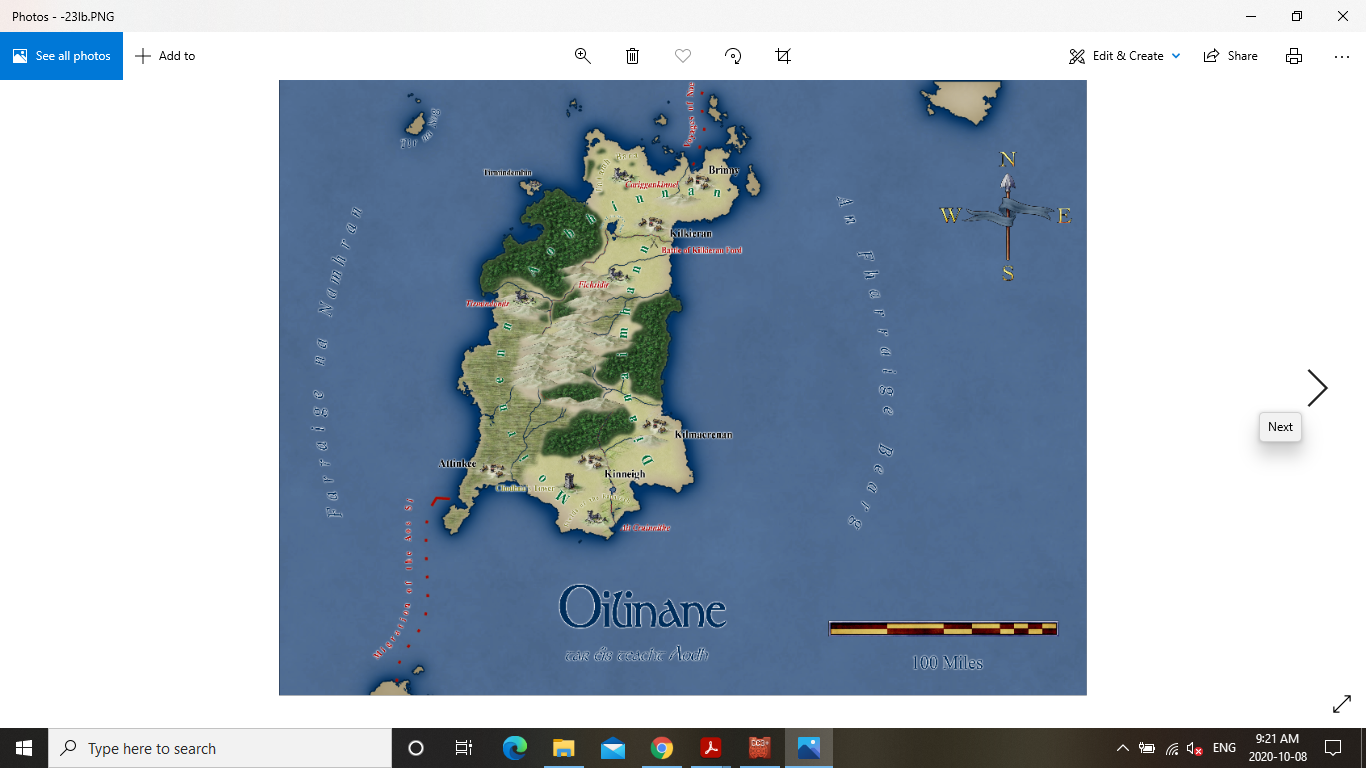
A little while ago, for a Facebook challenge, I presented the following island which was based very roughly on the geographical region of Connacht, in Ireland, although in retrospect its too large. There is a second island, to its south, that I originally intended to base off the old Irish province of Ulster, but am now thinking of dividing up between Leinster and Munster, and then having Ulster on the mainland even further to the south. I should note that the region is being mapped in the southern hemisphere, so that south is toward the pole, which should explain my thinking. These three areas, would then have roughly the same area as Ireland, though Leinster and Munster would be smaller, while Connacht would be much larger than it was historically. Clearly I should have planned better, but I just kind of dove into the challenge without thinking about all of these intricacies.
Anyway, regarding this island, the straightness of the eastern coast bothers me a little, and I had explained it away by referencing the straight coasts that do exist in the world (ie. the Iberian peninsula). I can't shake the feeling that it still looks unnatural though. I'm wondering what others think?


![[Deleted User]](https://secure.gravatar.com/avatar/c75d9a245b74d9c59be0999ea81ca541/?default=https%3A%2F%2Fvanillicon.com%2F92add7f8c954488718110edc4896ad39_200.png&rating=g&size=200)

-
October Community Challenge - City Streets - VOTING POLL in first post
This is a great idea. I'm wondering if it might be helpful to post the link the the fcw of the city, if one exists?
I would like to claim 11, with 16 as a backup if someone steals it.
-
Welcome to the Updated Forum
Thanks for your work, Remy. I really love the way the site looks now. I've been meaning to come back and be more present in the forums, and this is definitely a good time to do it!
-
WIP: Aiyedjembe
HI Barliman,
I've included a png with my settings here. It didn't come out exactly like this. I kept changing the north pole until I got an arrangement which fit most of the map in a centered set up rather than being cut up by the edges. I didn't actually find the best set up right away, but I had done a lot of work so I accepted it. Every time I open up FT, it loads these settings and gives me a new map, and most of them are pretty fantastic and amenable to good centering. I've saved about thirty different worlds and even done full climate workups for one of them. I'd be happy to throw you a few files if you like.
For curiosity's sake, I'll just mention that this is 0 N 130 E, while the best fit is actually 30 N 118 E, if I recall correctly. I actually did a lot of experimenting with pole positioning, as I was exploring the idea it could be used to simulate continental drift. It was fun, and I came up with some cool alternate maps, but ended up returning to this one.
As a caution, if you do fool with the poles, settle on the final position before doing time-consuming incisions, as they often become undone. Also, do your best to keep land off the 180 as this will give you profound incisions you don't want. I do know how to fix them though, if you have trouble.
I could go on all day about FT, I really do love that program and learned how to do some fun stuff in it.
A.
-
WIP: Aiyedjembe
Hey Sue,
I've already spent a lot of time with Geoff's cookbook, and then a few interesting tutorials that were built off it at Cartographer's Guild. I actually came up with about eight different techniques to model the climate of the world, and then decided to just rebuild the rainfall and temperature maps according to some basic earth principles, with reference to some maps I found online. So I set up a basic bar approach for the temperature, with four different temperatures, and then created intermediate areas that were dependent on ocean currents, so that where ocean currents went the temperature would be modified. I then smoothed the final result at several different values, comparing each one to the real world map. The temperature map I posted was smoothed at a value of 150, and I feel is fairly close to the earth's (but I'm open to hear countering opinions).
I am about half way through a rainfall map using similar techniques, although of course its a whole lot more complicated.
The reason I want to do worldwide climate is I want to simulate migration on the planet to determine where cultures are.
Any thoughts?
And thanks for hunting that down for me, even if I had already seen it.
A.
