


Wyvern
Wyvern
About
- Username
- Wyvern
- Joined
- Visits
- 3,267
- Last Active
- Roles
- Member
- Points
- 5,585
- Rank
- Cartographer
- Badges
- 24
Latest Images


-
Community Atlas: Map for the Duin Elisyr area, Doriant
Been MIA for most of this week thanks to RL things. However, another short update.
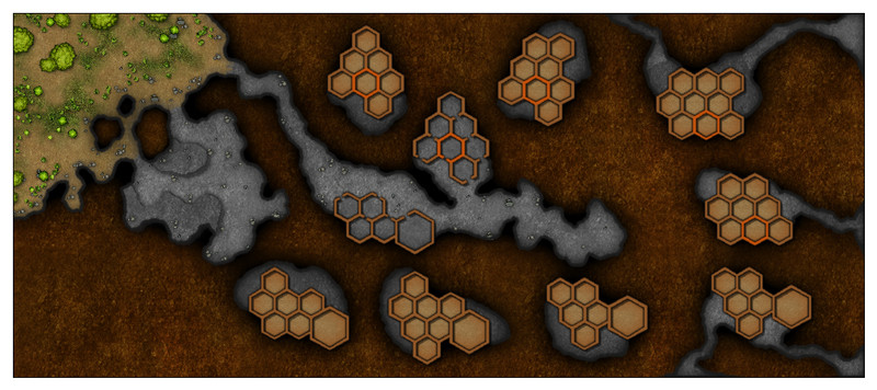
More tweaking of effects, and adding new, mostly minor, items, along with some new small outdoor patches for the upper tunnel exits this time. I also added some floors to the basal hex-rooms, to make them sit a little better there.
While experimenting with the bevel edge lines for the upper tunnel inner ledges, I chanced upon a better looking option for those raised areas in the southern entrance cave too. I also ended up redrawing both the floors for the upper exit tunnels, so the bevel would work there, and the walls for those same three upper caves. The latter showed up as a problem when I added some of the outside dirt texture patches, as it was suddenly obvious there were some unwanted lines and pseudo-gaps in the wall lines due to the classic "too many nodes" problem. For some reason, the Break command wouldn't work on those two right-hand edge corner exits, possibly because I couldn't identify exactly where the lines were due to the nodal weirdness, and trying to delete nodes turned into a complete nightmare, as some of the lines looked almost as if they had gone around the entire map-border-line edge. So I just cut my losses, deleted all those wall lines, created a new drawing tool to prepare identical, but open-ended, wall-lines to those in the default cave tool, and redrew the lines by tracing the cave floor areas and, without tracing, to a little beyond the map border.
This amount of time-consuming, if relatively minor, amendments is pretty typical for this stage of the drawing process, I find, as it's among the most important elements to get as right as possible.
Ran out of time to get the hex-room doorways cut, with labelling and a scale-grid to follow. After that, it'll be time to start the area map for where this map's going to go in the Atlas...


-
[WIP] Temple of Fah (May Annual: Stairs and Steps)
Very pleased you'd found a good, workable solution to the "erosion" issue.
It is surprising sometimes how little extra you need to do to distract from the repeating texture patterns. Of course, there are others where you struggle to manage this no matter what you try, but hey!

-
Floor Tiles
Dread's the one that uses a Jenga tower to resolve actions instead of dice, so it isn't for everyone (if you have real-life dexterity issues, say), although speaking as someone who has such problems, it can be a fun system for one-off games. I once saved the remaining survivors from a zombies-in-space game at a Free RPG Day some years ago, by doing the impossible and removing probably the last Jenga piece before the tower would have collapsed, to achieve the sort-of win (you don't really "win" in Dread though!). We had folks from the other tables imaging the tower after the event, as they couldn't quite believe it either!
-
Community Atlas: Map for the Duin Elisyr area, Doriant
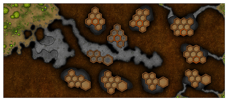
Didn't get quite as much done as I'd hoped before reporting back here (though that's often the case), as sometimes tweaking the effects or making subtle colour changes just needs more time that you can easily predict. However, a bit further forward:
The basic cave outlines were swiftly converted from their previous white outlines by simply using the "Change like draw tool" option under the right-click list of the :CC2MCHANGE: button, although the floors had to be moved to their correct sheet for the effects to work after that too. I also added a "Solid 30 Bitmap" fill over these new floors (by simply copying the existing floors to a new sheet, and changing the properties of the floor piece so-created), to try to give an impression that the floors aren't attached to the hex-rooms on these upper levels. Note that two of the exterior exit upper levels in the lower right corner haven't had their new fills added yet, because they have to be drawn in freshly, as the tunnel floors are really floors at the new level, with a ledge where they begin. That's all still to sort out.
The hex-room walls were simply converted to their thicker, coloured versions by changing properties of the original white versions. I've also changed the "identified" room colour in the upper cavern to be less jarring, though I think now this may be too subtle! Suitable floors, hopefully looking enough like the cells in a beehive, were added by again copying the hex-walls to another new sheet and amending their properties accordingly. I also added an Inner Glow effect to this sheet to alter the look of the floors a little more. I've not added doorways (which may include floor hatches - haven't finally decided) to the upper levels yet, as I wanted the basic room shapes to be completed first. Cutting the walls beforehand would have made this problematic.
-
Community Atlas: Map for the Duin Elisyr area, Doriant
For the upper hex-room cave levels, I hand-sketched some ideas using a mix of graph and tracing paper to make sure I had the general sizes and layouts correct. Then, I redrew those into the CC3+ map, using the same TEMP Sheet and Layer as for the base hex-room layouts earlier. I decided not to scan-in and insert the hand-drawings this time, as I knew things would need adjusting in-map to fit with what was already drawn there.
After that, a great deal of tweaking, changing and moving about followed, to improve the look and layout of the whole. Indeed, this took so long, I didn't have time to start converting the drawn lines to parts of the map, although I did identify one new item, which was the need to indicate a specific hex-room in all the "northern" hex-room cave layouts, to help with orientation (the one larger hex-room on all the "southern" layouts solves that problem there already).
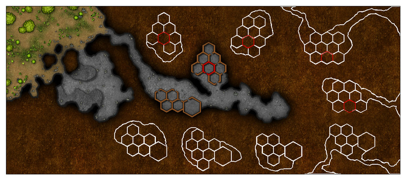
Oh, and I changed all the layout lines to white!
Layout of the upper levels, and what each of these levels will look like, are of course subject to change once converting them to the appearance of the rest of the map begins, and the red-wall room isn't definitely how it will be in the end either. The external exits from some of the higher levels were suggested as existing by the Inkwell Ideas book for these designs, incidentally.
While these were all essential tasks, hopefully, there'll be some "real" mapping progress to report by next time!

