


Wyvern
Wyvern
About
- Username
- Wyvern
- Joined
- Visits
- 3,267
- Last Active
- Roles
- Member
- Points
- 5,585
- Rank
- Cartographer
- Badges
- 24
Latest Images


-
Community Atlas 1000th map Competition - with Prizes [August/September]
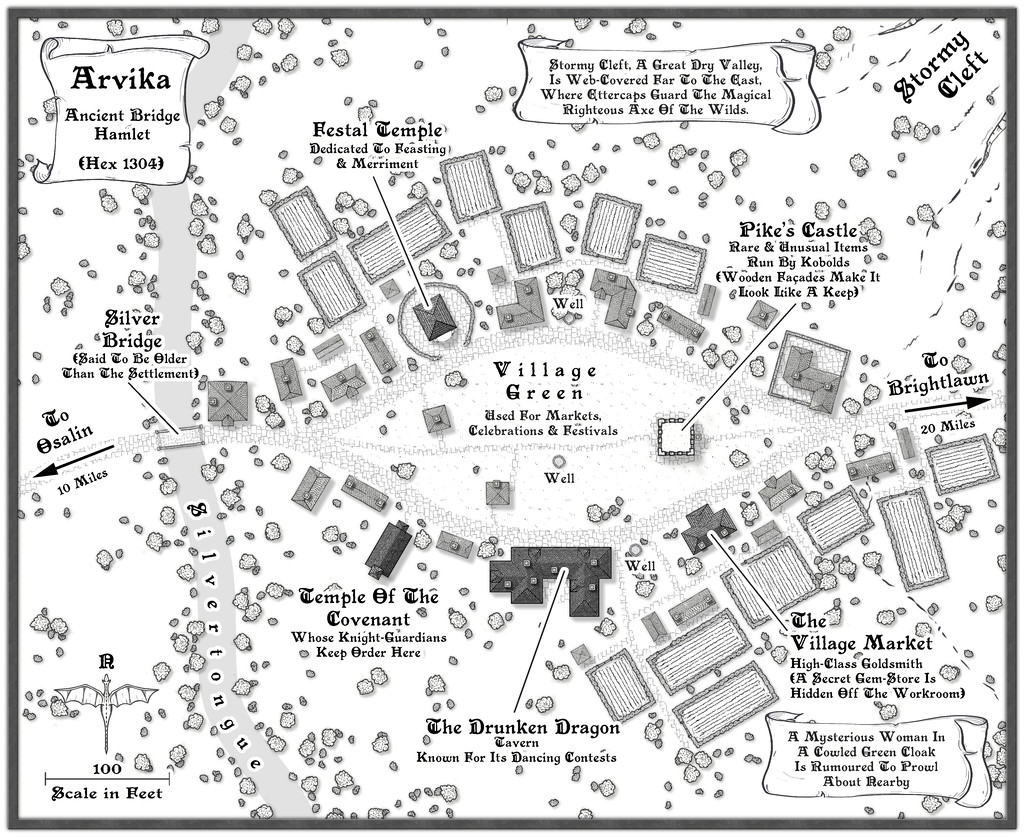
Map six is for the hamlet of Arvika:
I've made the usual updates elsewhere on the Forum & Gallery too, while the FCW and PDF notes follow:


-
[WIP] Community Atlas, 1,000 Maps Contest: Villages in The Whispering Wastes of Haddmark, Peredur
Map six - Hex 1304, Arvika:

Arvika was one of the three settlements in this area that were originally shown on the existing Atlas map. In the absence of any text notes for it there, I simply looked at what the symbol was - a hamlet. As luck had it, no random feature was selected during the creation of my Whispering Wastes regional map for the hex it was in, but there was something in an immediately adjoining one, a mysterious ravine partly filled with webs, where a legendary artifact was guarded by a nest of Ettercaps. So I simply moved the ravine into the hamlet's hex, combining both elements. The hexes are six miles across, north-south, after all, so there's room for a lot more than just a single feature in each one.
The setting for the place was to be in a river valley, the Silvertongue, and I randomly discovered instead of the fords, so popular elsewhere so far, the proximity to the uplands had clearly provided stone enough for a bridge here for once, and it also turned out to be notably ancient, something that, like the Stormy Cleft ravine, simply helped reinforce why this hamlet had ended up being shown on the Atlas's area map, while other, seemingly larger or similarly-sized, settlements in the Whispering Wastes had not appeared there. Mapping it was straightforward enough, with the contour symbols fitted-in to act as the entrance to the ravine, although I did add a few more fields than I'd initially thought to provide some further interest around the settlement itself, which also lessened the impact of the ravine on the whole drawing.
-
[WIP] Atlas Contest: Village of Djayet (Gold Coast, west coast of Doriant)
Question: if I clone a symbol to modify it, can the modified version still be used in the Atlas?
So far as I'm aware, yes. I've done it before certainly.
-
[WIP] Community Atlas - Eknapata Desert
Interesting, although there doesn't seem much more here than was already shown on the main Gold Coast map.
Might be worth adding a few more smaller features (dry valleys/wadis, rockier flat areas, dangerous soft or otherwise unusual sand areas, etc.), naming all the smaller settlements, and maybe naming the nomad tribes/trade routes suggested by the led camels too.
You should definitely add a scalebar.
Not sure if the labels mightn't be made clearer as well, perhaps using a smaller font size, so the place-name labels hide less of the "interesting" terrain.
Perhaps consider making the trails stand out a little better too, and maybe green-up the watercourse and lake edges everywhere more. The Nile creates a green valley surrounded by desert, for instance, so the active river and lake here should too.
-
Community Atlas 1000th map Competition - with Prizes [August/September]
The fifth map in my Whispering Wastes set is the weird necropolis setting of Osalin Village:
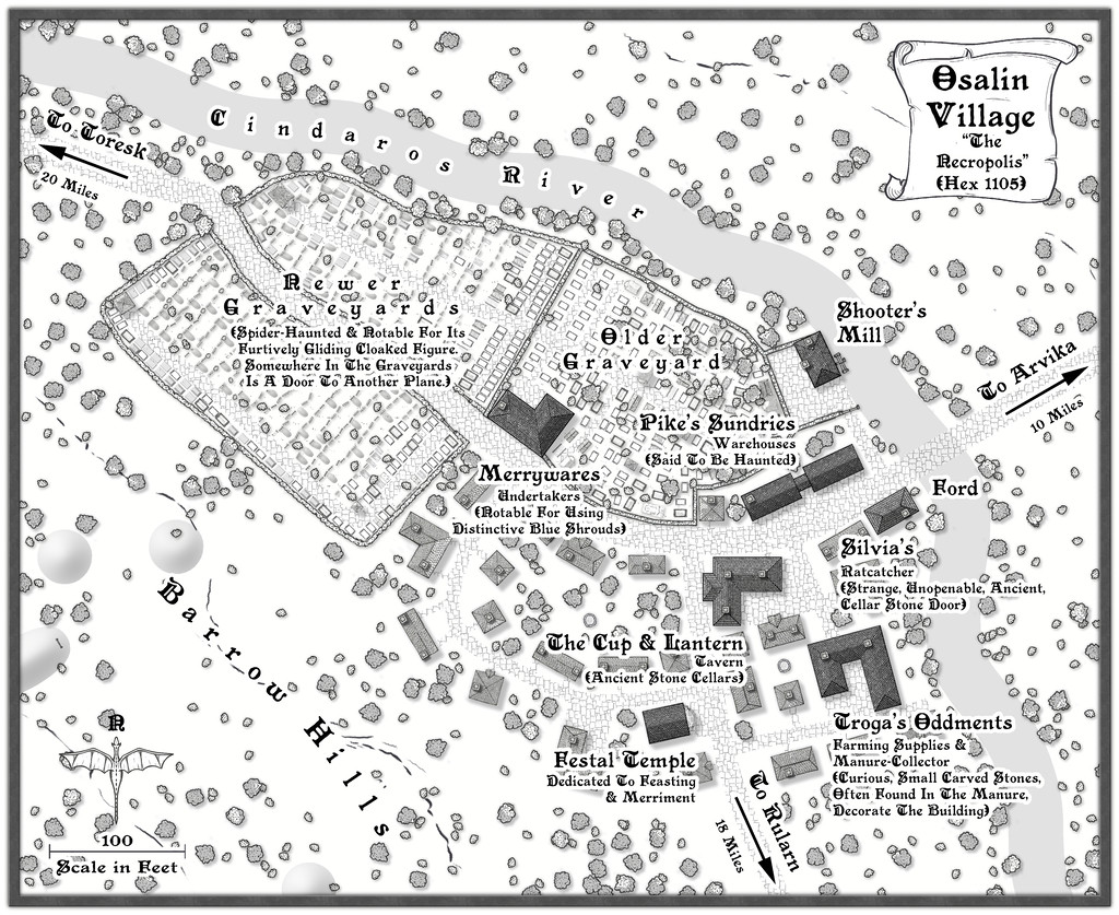
I've added some fresh notes about it to my WIP topic, and there's a higher-res map in my Gallery for this place too. Meanwhile, the FCW and PDF notes files are here:

