


Wyvern
Wyvern
About
- Username
- Wyvern
- Joined
- Visits
- 3,267
- Last Active
- Roles
- Member
- Points
- 5,585
- Rank
- Cartographer
- Badges
- 24
Latest Images


-
[WIP] Kingdom of Gongodûr
A few of the labels are a little too close to the map edge - one or two seem to run slightly beyond it, e.g. Wirbilini Woods and Taggtrum R(iver) - which is another issue with text in CC, where the text's position shifts at different resolutions/export settings.
That can usually be solved by making sure you have the correct location point for the text before placing it (such as "mid left", "top right", etc.), because the text will only expand/contract away from that point, so it's effectively fixed to that spot. It can be tedious having to remember to change it every time if you're doing a lot of labels in different places, although you can use the shortcut arrow keys instead once the text is on your cursor to be placed.
You mentioned thinking of putting some elements onto a separate layer that could be toggled on and off. For this map, I think it's probably better to have both the regional borders and their labels on all the time. With just the labels, it's impossible to guess exactly what they refer to otherwise, including identifying how far Gongodur extends.

-
Community Atlas 1000th map Competition - with Prizes [August/September]
Last of the ten small settlements in my group is Fairbridge Village:
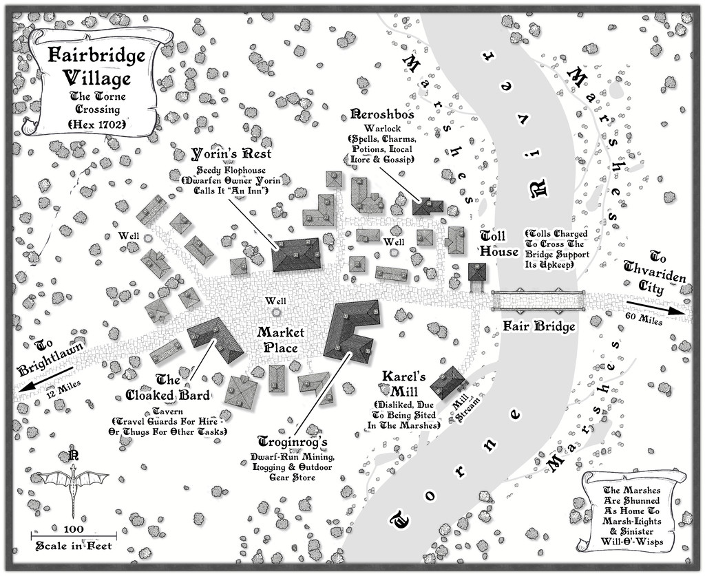
And here we have the last of the accompanying FCW files, with the PDF notes for this one. WIP topic updated as well, and a higher-res version of the map in my Gallery now too.


-
[WIP] Kingdom of Gongodûr
Sue's saved me having to comment about the fonts - thanks Sue! - but for the labelling in general, because there's quite a lot happening mostly in the mountains, I'd suggest thinking of moving the labels, where practical, out onto the plain grassland green areas, which might help with the font style & colours issues. I'd also be inclined to think of shortening the title scroll, and moving it too onto the plains, so it's hiding less of the "interesting" terrain it currently partly overlies.
The river lines are definitely improved now. That around Mt Haymish and Tuncaster is a little too angular in places though (Beck River). Where that same river curves towards Middleham, it may look better to have it follow the break in terrain fills, instead of cutting through them. You might find it easier to erase and redraw this river using a smooth-path river drawing tool, instead of trying to adjust it where it is now. I usually end up doing that, at least!
On the political borders version, the edge colours are very distracting, and make it hard to know where the river lines are. I suspect it would look better with just the shading effect on the areas outside Gongodur, as that'll still highlight where the borders are sufficiently, with luck. You may need to add some new shading to the areas on the east and south map edges, however. This would avoid the oddity of the mountain peaks being overlain by the border colours (though you could move those lines to a sheet below the mountain symbols instead, of course).
Unless there's a strong plotline reason, it may be worth reconsidering having the southern Gongodur border cutting through the symbol in the Valley of Dread, as presently.
EDIT: Forgot! The compass indicator probably needs enlarging, and again moving to somewhere less terrain-interesting. It's rather too well-hidden where it is now (which is naturally why I forgot it 😉).
-
Community Atlas 1000th map Competition - with Prizes [August/September]
Map nine in my little set of ten is for Skara Hamlet:
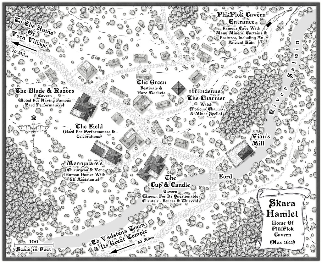
The usual WIP and Gallery updates are elsewhere on the Forum for this map, plus the FCW and PDF notes files for it are below:
-
[WIP] Community Atlas, 1,000 Maps Contest: Villages in The Whispering Wastes of Haddmark, Peredur
The penultimate map in this series of ten is from Hex 1611, Skara Hamlet:

Last of the three settlements marked on the Haddmark regional map for the area that is now the Whispering Wastes, this was in another hex that missed out on being randomly selected as holding a feature of interest, so one in its immediate neighbour to the northeast was simply swapped-in, which is how we have PlikPlok Cavern as a notable element on this map, or rather the entrance to it. Beyond that, looking at the general area map, it seemed likely this settlement would form a focal point for the surrounding farming and logging districts, given the western fringes of the Skara Bray hills, in whose southwestern tip Skara is located, have denser woodlands shown on them, along with the hills themselves, and the relatively nearby major Torne River. It also felt plausible that such places would be quite scattered, so the settlement itself was allowed to spread out here too, helping make it seem more important than the number of buildings alone might suggest.
While constructing the map, and having the overall close-by region in mind, I decided to add more walled, paved yards here than in other places, since the proximity of the upland surroundings - hinted-at by use of the contour and cliff symbols - suggested a more readily-available source of building stone for Skara. In-keeping with its somewhat lowly status though, the wall-lines aren't always especially straight. Nearer the centre, The Field and The Green ended up as open spaces almost by accident, as while I wanted to add some denser woodlands around the periphery, I didn't want those to become too dominant. Plus The Blade & Razors needed an outdoor space to expand its events into, and the significance of Skara to the surrounding areas meant some kind of open space for occasional markets - even though no specific market place was randomly assigned to it - seemed a natural addition as well. As mentioned before, sometimes these things just happen almost by themselves. Meanwhile the random option for a chirurgeon was amended to become also a vet, given the significance of livestock hereabouts.
Final map now approaches!

