


Wyvern
Wyvern
About
- Username
- Wyvern
- Joined
- Visits
- 3,267
- Last Active
- Roles
- Member
- Points
- 5,585
- Rank
- Cartographer
- Badges
- 24
Latest Images


-
Hex map
Hexcrawl Toolbox was funded on Kickstarter in late 2022 and physically delivered in August last year (I backed the KS). The beta of the app has only just been released to KS backers last month, as although it was the final stretch goal for the campaign, it's been a year in development already - computers, you know 😉!
Next month, Games Omnivorous are launching their next in this line of hex products, "Boreal Frostlands", as a crowdfunding project on Backerkit. The artwork samples on the sign-up page there look just as wonderful as their previous products already!

-
Community Atlas: Barrows of the Ferine Magi area, Feralwood Forest, Alarius
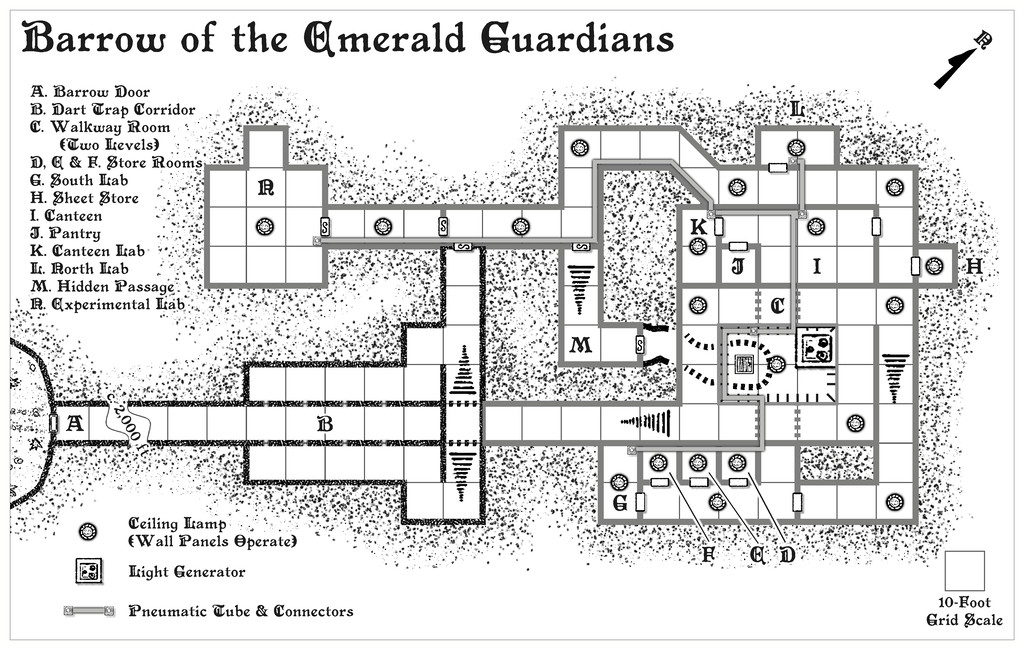
Well, that was a longer break than I'd anticipated. However, I can now update progress with this project today, having completed the first map, for the Barrow of the Emerald Guardians, and its notes. Typically, if unintentionally, along with other RL issues this month has brought so far, this first map was also the more complicated of the trio to prepare, as it had been randomly assigned both a light generator and lamps, and a pneumatic tube communications system, both of which needed adding to the map. The lamps and generator were straightforward enough, as simple individual fixtures. The pneumatic tubes though needed drawing-in as well, however, given each is meant to be about a foot, 30 cm, in pipe cross-sectional diameter. Lines are, of course, simple enough to draw onto a CC3+ map, but getting the colouring to work well enough in greyscale turned into a bit more of a challenge, and ultimately, I opted for a thin, dark outlining glow effect as well to get the tubes to stand out without making the walls seem like irrelevances. Plus the wall colouring had to be changed as well (several times, in fact, though that doesn't show here, of course...).
This then is the (probably, subject to later checking) final map in its "ordinary Nibirran" view:
And this is the view with the hidden passages those not from Nibirum can ordinarily see, displayed:
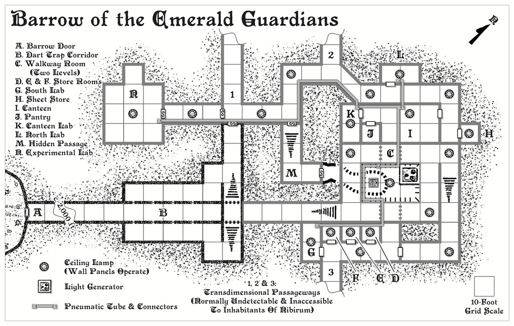
In terms of map contents and denizens/potential denizens, these were drawn, and then adapted, from, primarily, the Numenera RPG for this map. In the notes, I've identified the original source object or creature type, in case anyone should want to use the "standard" versions instead of my amended ones, for which I've also provided Shadowdark stats and comments. We have a couple of Human inhabitants, both tech-savvy mage-like inventors of sorts, and a host of curious magic-like gadgets they may have constructed or be working on (or indeed, even be using). There are also oddities from the non-Nibirum world outside (since I've assumed there is a settlement of some sort beyond one or other of the "exit" passageways), creatures that have wandered, or may wander, in, including a particularly vicious group of vaguely humanoid, communal, raiders that communicate purely by telepathy, and which have a thick, long tentacle each instead of a head. There's also a wandering envoy, a loosely insect-like humanoid, jerky of motion, actually a technological construct, liable to be off-putting to folks, despite only wanting to establish peaceful contact with other humanoids. That one can summon a group of warriors of similar type should the need arise, since there seems the possibility for some curious alliances to form among the folks here when added-to by a group of Nibirran adventurers. And then there's also the Mysterion (as I've called it), essentially a Vorlon from the old Babylon 5 TV series, should you recall that. That one's going to be in all three of the Barrows, being extremely cryptical and enigmatic. I did promise weird!
Hopefully, not quite so long a gap till the next map's ready from this trio.
[EDIT 19 November 2024: Although I originally added the provisional PDF description for the map to this post, I've removed it now, as the final version has been submitted for the Atlas!]


-
Community Atlas 1000th Map Competition - The Winners
Indeed yes, very well done to all our winners - and to everyone who took part, regardless of the results.
Perhaps the most important achievement of all is the great contribution made to increasing the coverage of maps in the Atlas.
Onward now to the Atlas Map 2,000 competition 😁!
-
Live Mapping: Sticky Note Dungeon
Might be worth mentioning too that we found a minor glitch with the Sticky Note Dungeon Regular font, which has also been updated in the Annual download now. However, being a font, you usually can't just overwrite this on a Windows system, so you may need to remove the original font first (it should be in the Windows - Windows - Fonts subfolder) before you reinstall.
If you have already done a fresh reinstall though, just remove the font then do a repair reinstall using the Sticky Note Dungeon EXE file, and that should sort it (I have done just this as a check!).
-
Invisible entities outside of map on TEMPLATE layer
What Sue said! (Beat me to it, Sue, as I was almost ready to post my own notes!)
Plus, if you open one of the example maps from this CA28 style, you'll see there are seven such points on the TEMPLATE layer, so there'll probably be more lurking elsewhere on yours, probably behind what you've already drawn, in the area you didn't select.

