


Wyvern
Wyvern
About
- Username
- Wyvern
- Joined
- Visits
- 3,266
- Last Active
- Roles
- Member
- Points
- 5,585
- Rank
- Cartographer
- Badges
- 24
Latest Images


-
Jim Pierce 1947 - 2024
As Sue commented, Remy's notes say it all.
I've been following how things had gone for Jim since his last Forum posting back in April, thanks to Sue and Remy, and indeed it has been a very sad ending to one of the finest fellows in our community.
Jim no doubt has other, greater, adventures to map now. Hopefully, some of his inspiration can live on among all of us. Farewell Rutabagasteu (his YouTube handle).

-
Community Atlas: The Hall of the Seer, Glaciär Kristol, Ezrute
Third map in this group, for the Hall of the Seer, was actually drafted first, using the same style and look as established for all four underground maps in this "Explorer" dice batch, using the two dice designs involved for the layouts of the above-ground and subterranean segments, as mentioned last time. It was really this map though that led to establishing the "gritty" look of the stone-edged roads and paths outside, largely to help give a better contrast between the outside and inside of this little complex. Originally, I did think of just using gravel-filled polygons for the roads, but that appeared confusing with the similar dot-shading to represent the solid interior of the hill lying adjacent to the entrances. Ultimately, I did use the polygon drawing tool for both, altered by the stone edging outside, which with the trees, buildings and blank ground surface seemed to provide sufficient contrast.
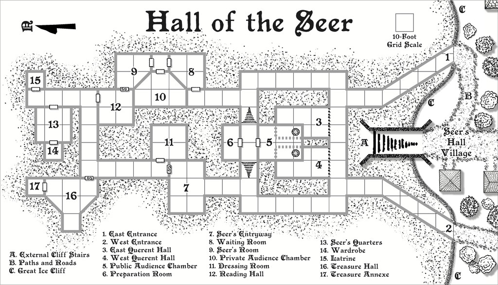
For the internal layout, this was largely what the dice designs provided, omitting the geomorphic connectors in places beyond this layout, and adding one secret door between rooms 9 and 12, as I wanted to provide an inner sanctum as the private domain of the Seer herself. This was chiefly because (and there are hints in the label descriptions) that the Seer had been randomly determined as a Frost Dragon from Shadowdark, modified here to be also an ancient, prophetic creature, able to shapechange to various forms under the local magical influences. There are also three "ordinary" Ice Dwarf Oracles as well (lesser, humanoid seers, in effect), who live in the Village, and provide aid and prophecies here too, when required. I decided to really push the legendary significance, importance and reliability of the Seer - who has the randomly-determined name of Leminsiskiel - to help enhance the significance of this little site overall. After all, there needs to be a serious reason for folks to traipse across the vast, frozen wastes of the surrounding larger region to get here!
As ever, there's more detail in the accompanying notes for the Atlas as to how the set-up here works, as it's not really intended as the traditional kill-the-monsters-and-steal-their-treasure dungeon, more a living place of importance for the lands around - and perhaps even further afield.
Next time, I'm heading off to map somewhere a little more tropical, a site in the Demosthenes Swamp of central-southern Artemisia, according to the random rolls...


-
Live Mapping: Latest Monthly Symbols
Just caught-up with the livestream VOD, and while obviously disappointed that Ralf didn't go with the peppermint volcano options (or early varicolor test if you prefer), it is a fun drawing!
Slightly weird that the VOD continued on through what was a break in transmission for the live viewers, but that's what happens when you're broadcasting from a strobing disco, as Ralf was 😉. Hopefully, whatever was causing that effect can be resolved before next time, as it was a little distracting at times.
I could have done with these hive symbols 2½ years ago, when I was preparing my giant ant nest map for the Community Atlas (Queen Mica's Scintillant Palace - Forum topic and Atlas link)!
-
Community Atlas: The Hall of the Seer, Glaciär Kristol, Ezrute
As I mentioned last time, this little trio of maps all grew up together, and not altogether in the neat order presented here. Realising early on that the underground complex was set to have a pair of entrances, reminded me that one of the still-to-come dice-design maps also had a couple of cave mouths in a cliff. Although that was from one of the "Ruins" dice, those designs also feature on the "Cities" dice set, die 6R from that (6R* in the Ruins set), without the ruined buildings, fallen trees, and so forth. So rather than use the Shadowdark settlement design rules to create the settlement, I simply reused that Cities dice layout, with a few tweaks, instead, to create Seer's Hall Village:

The mapping style was chosen a while ago for the ten small settlements in the Whispering Wastes of Peredur, which was reused here, with a variant design for the roads and paths, to give them their rough stone-edged, gravelly look, as distinct from the ice and snow elsewhere (one advantage of a B&W style!). I made the chimneys more prominent, given the high-southerly latitude, and adjusted the property sizes a little, as the inhabitants here are primarily Ice Dwarfs, a cold-immune, stocky folk, able to change into small animals and back when they wish (based on the Dverg from the Cursed Scroll #3 zine, writ larger, given the Dvergs are essentially arctic gnomes). In addition, the folk here also have pet Arctic Mastiffs, for a little more colour (cold-immune dogs, basically).
Part of the Village contents were determined from the Shadowdark rules, as before in Peredur, with some tweaks to fit the established setting here, given the whole place is only where it is because of the Hall of the Seer inside the large ice hill to the settlement's north. That cliff-line, with its entrances and stairway, and the two pylons on the hilltop were all from the dice design, like the placement of the buildings and the road layout, again with some adjustments to fit how the road was on the Plain map, as illustrated previously. Indeed, this map was changed partway through to accommodate elements of what the Plain map showed, including the Ley Line.
I tried fitting the existing cliff symbols from this style for the Great Ice Cliff, but ran into the same problem with these as previously in Peredur, where the lines won't fit to a suitable concave form. So I just drew the cliff as a polygon - well, actually two lines, mirror-copied to give a symmetrical four, and then added a shaded polygon by hand-tracing the lines. Dot-shading gravel symbols and fractal lines were then added to give it more of a "cliff" feel. The cave mouth was mirror-copied too, to look more or less identical, while the stairs reused a symbol and railing lines already drawn for the underground map, just copied across from that. The hilltop platform was an addition though, to give some purpose for the pylons and stairs, a place where the locals hold ceremonies at midwinter, midsummer, first sunrise, last sunset, and whenever the aurora is particularly strong overhead. Ceremony Hall has the feasting tables for such events, to be set up at the northern end of Pylon Way.
Next time, into Seer's Hill.


-
Moon Islands
Unfortunately, where I live, far from my original group, people play with "skins" and are too attached to rules, giving very little importance to Role Play (which for me is the most important thing in the game).
That's very disheartening. Is online RPGing a possibility for you? I know a number of Discords that have such groups, for instance, and I'm sure you could find one to better suit your preferred style of play, and in a suitable setting. I realise this may be impractical, of course, and not everyone (including me) would be able to, or comfortable with, online RPGing like that.
