


Wyvern
Wyvern
About
- Username
- Wyvern
- Joined
- Visits
- 3,266
- Last Active
- Roles
- Member
- Points
- 5,584
- Rank
- Cartographer
- Badges
- 24
Latest Images


-
Community Atlas competition entry: The Summer Palace of the Winter Queen
So having chosen my ten snowflake templates, it was time to test things out using CC3+. Summer Palace 1 was drawn using DD3, with the snow fill from SS2 Bitmap A as the backdrop:
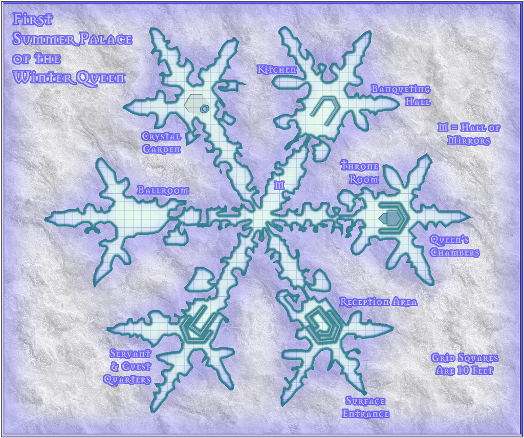
The Palace size doesn't encourage adding too much interior detail, as it starts to look cluttered very quickly, so I settled for showing simply the major, fixed features instead. There'll be text notes and a PDF to accompany all the maps in the final Atlas version, as normal. Each Palace version is intended to have the same seven main areas (Hall of Mirrors is one of the seven, incidentally), though not always in the same order - it is meant to be the same place, just with a different appearance each day, after all.
I was a little concerned about the narrowest passages, for all I'd checked with the grid on as I was drawing it - the narrowest are between four and five feet wide in the connecting passages. I decided early on that it wasn't going to be necessary to ensure access to every nook and cranny that didn't require direct access. It is meant to be a magically-grown, natural creation, and when real snowflakes can be so complex, that seemed an ideal recommendation to follow!
There was a degree of experimentation in this, as I wasn't sure how best to work the complex outlines at first, as you may find when you have access to the FCW file later - such as several overlapping floor segments in places. As I was just using the normal straight polygon drawing tool though, not fractal, I probably shouldn't have been too concerned. That's easy to say after the event though ?
![[Deleted User]](https://secure.gravatar.com/avatar/c75d9a245b74d9c59be0999ea81ca541/?default=https%3A%2F%2Fvanillicon.com%2F92add7f8c954488718110edc4896ad39_200.png&rating=g&size=200)


-
Community Atlas competition entry: The Summer Palace of the Winter Queen
The basic premise for this set of maps is that of a wandering sub-surface palace, which is occupied by/part of a powerful humanoid creature, possibly a deity (nobody's very sure). The palace magically shifts elsewhere every day, and changes its form at the same time. It is composed entirely of ice, and has the shape of a gigantic snowflake. It can only appear in an iceberg, in pack ice, an ice cap, or a glacier, or in a huge snow-cloud high in the air. There is always only a single entrance on the surface, surrounded by delicately intricate ice-sculptures of summer flowers and foliage (yes, even in the cloud); the rest of the palace is buried and completely hidden at all times (again, yes, even in the cloud!). The palace fits within an area at most roughly 600 feet by 500 feet, though its size changes from day to day.
My idea is to prepare a location map showing ten potential places the palace may appear, thus giving a simple random option of where it may be using a 1D10 roll. Another 1D10 roll will give the form and size the palace has that day, so I'm working towards having ten different versions of the palace map. The following map is an early version of the locations map, to give an idea of what I'm meaning:
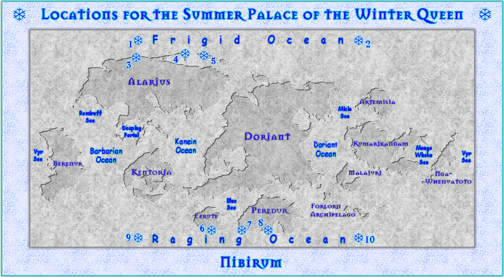
For this, I've basically reworked Shessar's beautiful world map into a very simplified version using one of Monsen's recent blog posts about representing subtly inset features on CC3+ maps. The numbered snowflake symbols (Wingdings font letter "T"s) indicate the potential palace locations. These are not going to be defined more precisely than this, so if the random roll comes up twice the same for two separate days, this just means the palace has moved, but not beyond the general area indicated - so "6" again means it's still somewhere in southern Ezrute, for example. It'll be up to the GM to decide exactly where in the general areas the palace actually is. This is not the final version, which will be a bit larger, and have more information; I've adjusted a couple of the markers since this version was prepared as well.
The 1 & 9 markers are for icebergs/pack ice somewhere on the great northern and southern oceans; the 2 & 10 ones are for the aerial snow-cloud versions, which will be found exclusively somewhere high above those same two oceans.
The palace and its occupier are intended to be things that might be useful to find for very esoteric information, but which are nearly impossible to guarantee locating at all quickly, even by those who know of their existence. I thought this might be an interesting addition for Nibirum more generally.


-
Is there a way to flip a symbol?
Some symbols are fitted with a shadow as part of the symbol, so be aware that this can make them look weird in comparison with symbols that haven't been mirrored though.

-
[WIP] It is strictly prohibited to throw jewellery into the lake.
"Spectacular failure" is simply another rung on the learning curve ladder. I have many such rungs...
-
Banners
Sue's Banners & Seals have been released into the wild now - all looking great, as expected!
Very well done Sue, and Ralf of course, for setting it all up - complete with varicolor seal designs.
Might have been nice to have had a graphic showing all the seal options in one place in the PDF Mapping Guide, as there are a lot there - standard letters, runes and blanks, aside from the pictorial designs shown earlier in this topic. I'd recommend copying Sue's graphic here and using it for reference if you're likely to be using the seals a lot to help out.

