


Wyvern
Wyvern
About
- Username
- Wyvern
- Joined
- Visits
- 3,266
- Last Active
- Roles
- Member
- Points
- 5,585
- Rank
- Cartographer
- Badges
- 24
Latest Images


-
Community Atlas: Errynor - The Isle of Zariq
As promised when I posted about The Cliff map, this is the first of the additional maps to accompany it, covering the Isle of Zariq, the surfaced tip of the huge seamount of the same name in the Frigid or Equine Ocean, some 750 km (470 miles) off the NW Alarius coast of Errynor.

I realise this may come as a shock, compared with many of my previous Atlas contributions, but there's just one version of this island's map!
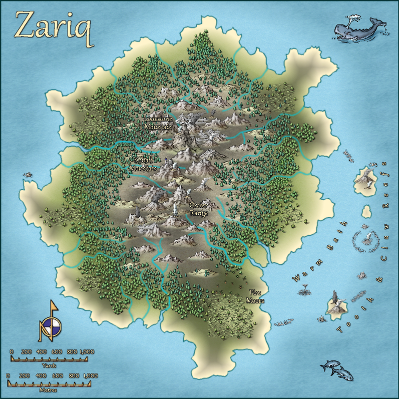
In-keeping with the element of chance employed to a greater or lesser extent in all my previous Atlas items however, the original base map was generated randomly, using the island generator on the Red Blob Games website. The final map has been reworked to some extent to better fit with what was intended here, though not by much.
The terrain symbols and some names are a little misleading (deliberately), as a quick check of the scales will show the entire island is only circa 4½ km (2¾ miles) in its largest dimension. The terrain is craggy and volcanic, as the surface sits on the main seamount's vent (it extends to the eastern offshore Tooth & Claw Reefs, so is partly underwater). The highest peak however, Lodestone Mountain, rises only 100 m (330 ft) above sea level. Smokes, mists and minor eruptions, including of geysers, are common features. The vegetation cover is generally stunted and windblown. Most of it produces plentiful seeds or berry-like fruits, as it was chiefly brought here by seabirds.
Indeed, seabirds are the main obvious living creatures for newcomers to the place, and those mainly during their spring-summer breeding seasons. There are also many kinds of small insects, arachnids and other invertebrates. There are additional creatures less commonly seen here, as outlined in the map's accompanying PDF and text files, of which perhaps the more intriguing is a tribe of small, blue-scaled, reptilian humanoids, the Kobalts (= D&D's Kobolds), who live in a warren of tunnels beneath Kobalt Mountain. For once, and despite the classic RPG random dungeon design joke from the early days of D&D, that "I just rolled for 40 Kobolds in this broom closet", this was in fact a long-standing decision, not a randomly generated one ?


![[Deleted User]](https://secure.gravatar.com/avatar/c75d9a245b74d9c59be0999ea81ca541/?default=https%3A%2F%2Fvanillicon.com%2F92add7f8c954488718110edc4896ad39_200.png&rating=g&size=200)
-
River Artifacts
As Loopysue suggested, this is indeed a too-many-nodes problem, and it's very common when drawing river lines using the fractal drawing tools.
The SIMPLIFY command should help reduce the number of nodes to the point where you don't get these artefacts, but you might also lose much of the naturalistic appearance along the river line, especially if you have to repeat the command on the line more than a couple of times.
I spent ages early on trying to locate and delete the individual problematic nodes, until I discovered said command...
You may find that drawing rivers using a straight or smooth line, rather than a fractal one, means you don't get this problem in the first place, but you will need to add more separate nodes to get a similar organically-natural-looking line for your rivers.
Personally, my preference is for straight lines, since at the scale of most overland maps, you won't notice the line segments as being straight at all, and they're much easier to adjust afterwards, should you need to, than smooth curved lines, because you can see more easily where the nodes are on straight lines, and how the line will change when you move a node, than with the smooth curve, where the node frequently isn't on the line, and where moving it can cause issues for adjacent line segments as well.

-
Seeking advice re world map and civilization placement
In terms of the planet's size and physical features, that's got to be your decision. If you're looking for ideas, I think you're already doing as much as is reasonable, by comparing the appearance to Earth's geological past. Mountain heights and (especially) ocean depths in deeper geological time are the more problematic aspects, the oceans because no oceanic crust is very old, geologically-speaking, which is where looking at other Solar System planets might be useful to get an idea of what the topographic range can be in the absence of large amounts of free water and its concomitant weathering effects (so before such things arrived). Different geologies can mean this isn't an easy comparison, if you're aiming for precision, of course.
Then again, Mount Kerofin in Glorantha was eight miles high (circa 13 km; from sea-level), so again, you pays your money, and... ?
-
Live Mapping: The Silver Mine
I am so far behind with these streams right now - too much reality lately...
Just caught up with the last part of this tonight, after several earlier failed attempts to view it over recent weeks. Fascinating work, as commented above already, and as ever, things would undoubtedly have proceeded swifter and more smoothly without needing to explain it so we could all follow along with what was happening! Or indeed without the late-stage catstractions ?...
[Cats seem to have an especial fascination with live video streams, I've noticed; not just the PF ones either.]
It might be interesting to have a finished mine map like this in the Community Atlas at some point. I don't think we've had a working mine as yet, but with approaching 560 maps there now, I may well be wrong in that. I have some planned silver deposits for some of those Errynor "40" maps, should anyone need a suitable (if still forthcoming) location ⚒️?
-
Community Atlas: Errynor Map 01 - The Cliff
When I wrote here to present details about my first land-based contribution to the Community Atlas Errynor in northwestern Alarius, I noted that 2,000 x 1,000 mile map had behind it a collection of forty 250 x 200 mile sub-maps, so that in essence, the main Errynor map was a summary of the major points from those 40. I also noted the plan was to present the 40 sub-maps separately over time for the Atlas. This map is the first of those - at last...
My initial thought was to prepare the sub-maps for each corner of the Errynor map, because those would encompass aspects of all the chief landforms, including the undersea areas which had been one main element in determining how the Errynor map was drawn. Wanting to try something different to that main map, I opted for the Herwin Wielink style, as that includes a number of useful options for the range of terrains needed.
However, like most CC3+ style packages, it largely ignores the undersea environment (as discussed in this Forum topic). So I knew from the start I would need to create some fresh symbols for that, though sadly I'm no artist! Needs must, though. Numerous problems beyond anything map-related meant progress with these was very slow, so it was only in February 2020 that those new symbols were completed:
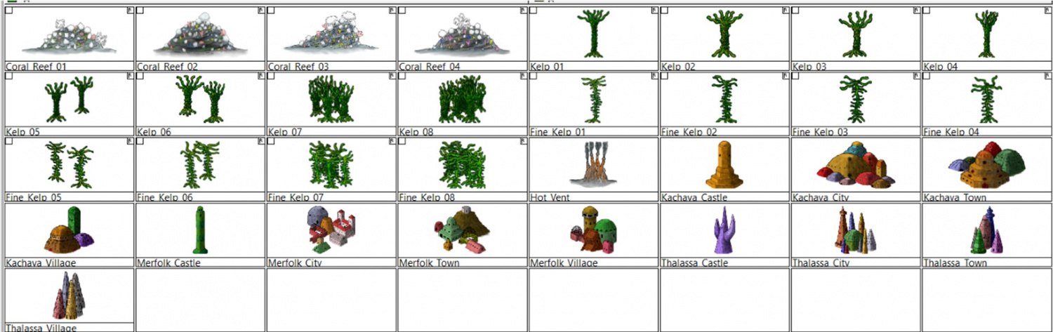
These were all tinkered together in GIMP, incidentally.
Knowing from the outset that I couldn't create anything with the artistry of HW's symbols, I instead drew mine taking aspects from that style only, such as the building bases having a similar fading "looseness" to help blend better into the underlying surface fill textures, and having the building shadows fall on the same side, for instance. Due to the size constraints on what symbol files added to the Atlas can be, I opted for just this very limited number, as I knew others already in the HW style could be reused for additional types quite readily. Of course, as we've discussed repeatedly on the Forum previously, further variants and extra items could be added almost ad infinitum!

