Wyvern
Wyvern
About
- Username
- Wyvern
- Joined
- Visits
- 3,266
- Last Active
- Roles
- Member
- Points
- 5,584
- Rank
- Cartographer
- Badges
- 24
Latest Images


-
Community Atlas competition entry: The Summer Palace of the Winter Queen
Palace 4 was also done using the CA7 pack, but this time in the Modern Caves style, though again, that may not be entirely obvious!
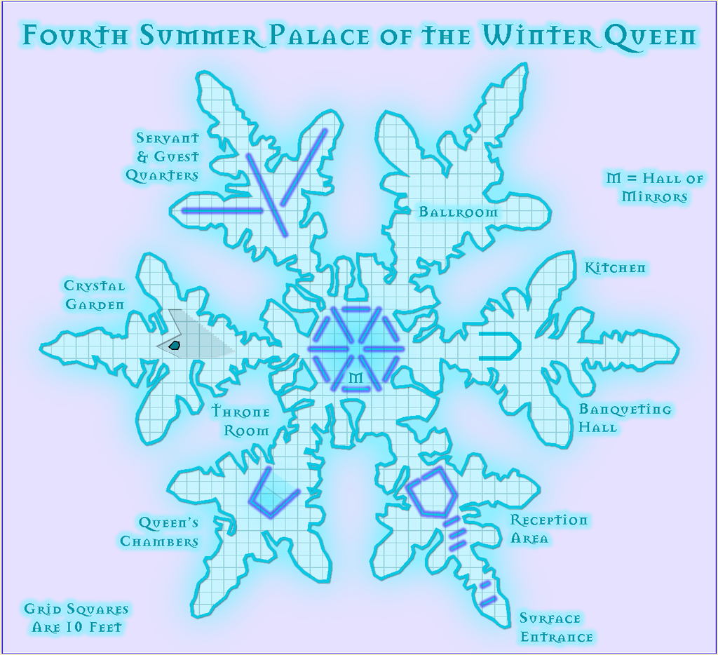
Some of you may recall I used this same style pack to construct The Hive map last June, which perhaps shows the versatility of this pack, like a good many of the CC3+ styles once you start tweaking the parameters and changing some of the Effects settings.

-
Community Atlas competition entry: The Summer Palace of the Winter Queen
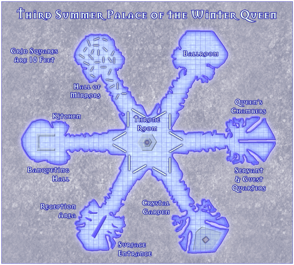
The third Palace map was done using the Caves pack from the first year of the Cartographer's Annual, in CA7, though you might be hard-pressed to tell! After some experimentation, I opted for the Fog, Green Bitmap fill, as with a little colour tweaking, its texture has an interestingly ice-like look - to my eye, anyway! It's also slightly transparent as a texture, so the underlying Dirt, Grey 1 background has an influence on it too.
The Locations map continues to be tweaked and adjusted still. This is its form after I finished the Third Palace map:
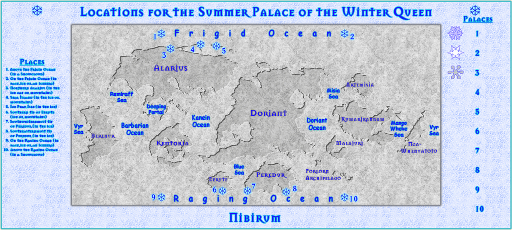
I've just been using copy & paste versions of the floor designs for the "Palaces" list, since that way, you get an impression of the overall form of each, if in a very simplified/condensed way. It'll need further tweaking before this one's finished, of course, once the rest of the Palaces are filled-in. The "Places" list could probably handle a slightly larger font size, for instance. For now, I wanted to make sure I'd simply got all the key text there though.

-
Community Atlas competition entry: The Summer Palace of the Winter Queen
Thanks folks!
@Fersus - Yes, I wondered about a hexagonal grid. However, over the past year, I've been involved in discussions about the use of movement grids in RPGs more generally elsewhere, and the consensus has been almost exclusively for square grids (or occasionally none at all). They're such a feature of most published dungeon maps, it's hard to break away from that, I suspect. Plus because hexes don't scale equally in all dimensions, a square grid works better for estimating distances for the GM by-eye.
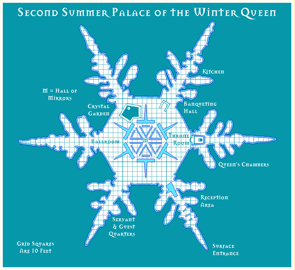
Given the whole point about participating in the Atlas, and contests like this too, is to try different things, at least from time to time, my intention was to try to make each of the ten Palace maps different. So for the second one, I picked the Old School Blue style from CA12 (also known as the Create Your Own Style pack). Blue, ice, seemed apt!
For continuity, I've decided to stick with the Mason Serif Bold font that comes with CC3+, however.
![[Deleted User]](https://secure.gravatar.com/avatar/c75d9a245b74d9c59be0999ea81ca541/?default=https%3A%2F%2Fvanillicon.com%2F92add7f8c954488718110edc4896ad39_200.png&rating=g&size=200)


-
Community Atlas competition entry: The Summer Palace of the Winter Queen
Along the way, I let myself get a bit distracted, and decided a CA3 portrait of the Winter Queen might be an interesting addition to the map set, with a hint of the SS2 Bitmap A Snow Frozen Lake fill texture for the border design, which thanks to the standard CA3 bevel effect, looks rather like fine marble now:
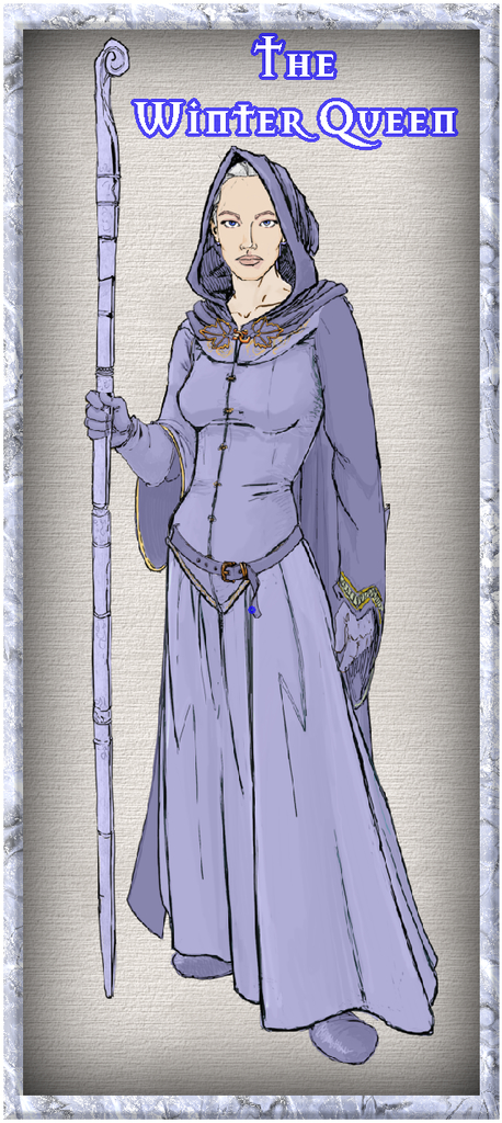
She's intended to be between 8 and 9 feet tall in (imaginary) reality, 2.4-2.7 metres.
-
Community Atlas competition entry: The Summer Palace of the Winter Queen
So having chosen my ten snowflake templates, it was time to test things out using CC3+. Summer Palace 1 was drawn using DD3, with the snow fill from SS2 Bitmap A as the backdrop:
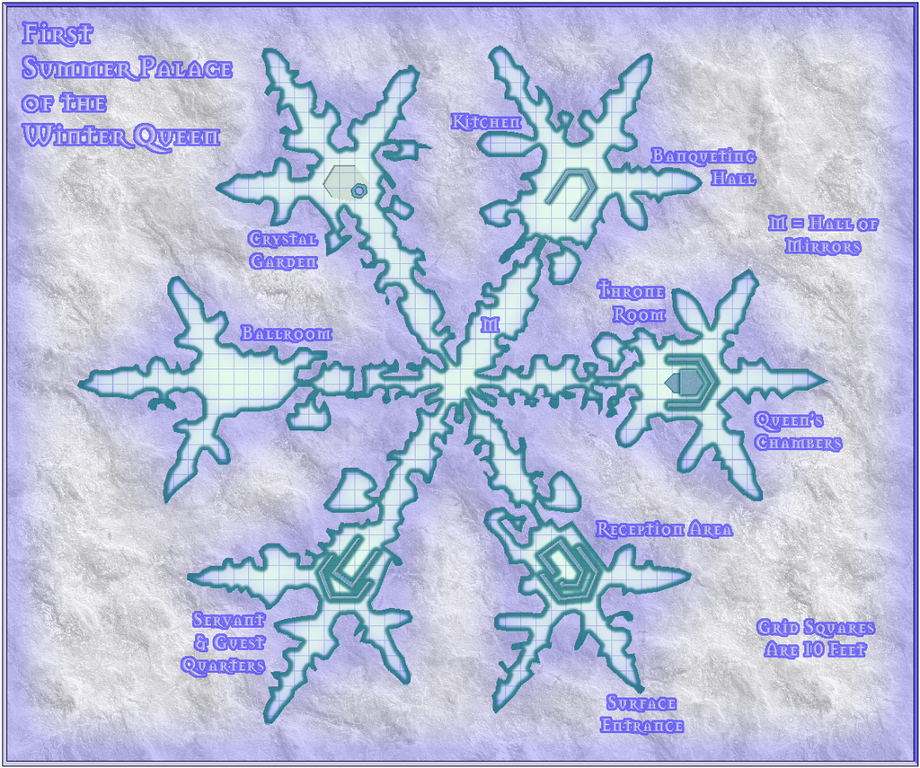
The Palace size doesn't encourage adding too much interior detail, as it starts to look cluttered very quickly, so I settled for showing simply the major, fixed features instead. There'll be text notes and a PDF to accompany all the maps in the final Atlas version, as normal. Each Palace version is intended to have the same seven main areas (Hall of Mirrors is one of the seven, incidentally), though not always in the same order - it is meant to be the same place, just with a different appearance each day, after all.
I was a little concerned about the narrowest passages, for all I'd checked with the grid on as I was drawing it - the narrowest are between four and five feet wide in the connecting passages. I decided early on that it wasn't going to be necessary to ensure access to every nook and cranny that didn't require direct access. It is meant to be a magically-grown, natural creation, and when real snowflakes can be so complex, that seemed an ideal recommendation to follow!
There was a degree of experimentation in this, as I wasn't sure how best to work the complex outlines at first, as you may find when you have access to the FCW file later - such as several overlapping floor segments in places. As I was just using the normal straight polygon drawing tool though, not fractal, I probably shouldn't have been too concerned. That's easy to say after the event though ?