


Wyvern
Wyvern
About
- Username
- Wyvern
- Joined
- Visits
- 3,266
- Last Active
- Roles
- Member
- Points
- 5,584
- Rank
- Cartographer
- Badges
- 24
Latest Images


-
Community Atlas: Wyvern Citadel Defence Zone on Kentoria
Well, I thought I'd finished the above-ground castle, until I realised I'd forgotten the courtyard horse-trough! Isn't it always the way - some small detail that just throws out all your plans? While fitting that in, I discovered I'd somehow managed to shrink the access-stairs platform adjacent to it - essentially, I just drew the trough into the Ground Level map, and then copied & pasted it over to the First Level one using the standard 0,0 coordinates for the paste. Where it no longer fitted snugly by the platform. So one horse trough, lot of redrawn platforms on all the other maps...
Anyway, this is the upper, Fourth, Level for the Citadel, without grids, so you can play "spot the horse trough":
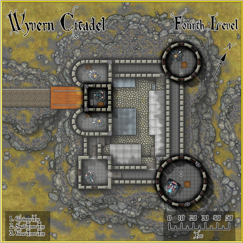
There are just the three highest tower tops on this level, with more of those Lightning Cannons, though you may notice the different one on the larger round tower. That's the Mark V Strickfaden, still a bit experimental/temperamental, and nobody really likes having to test-use it currently. That's also the tower where any visiting wyverns and riders can land, though that only happens for very urgent matters usually. Unless someone with prestige wants to make An Entrance. Great way to end up on A Charge unless you're particularly senior, naturally!
So, having (probably...) finished the upper storeys of the castle, I headed off below ground:
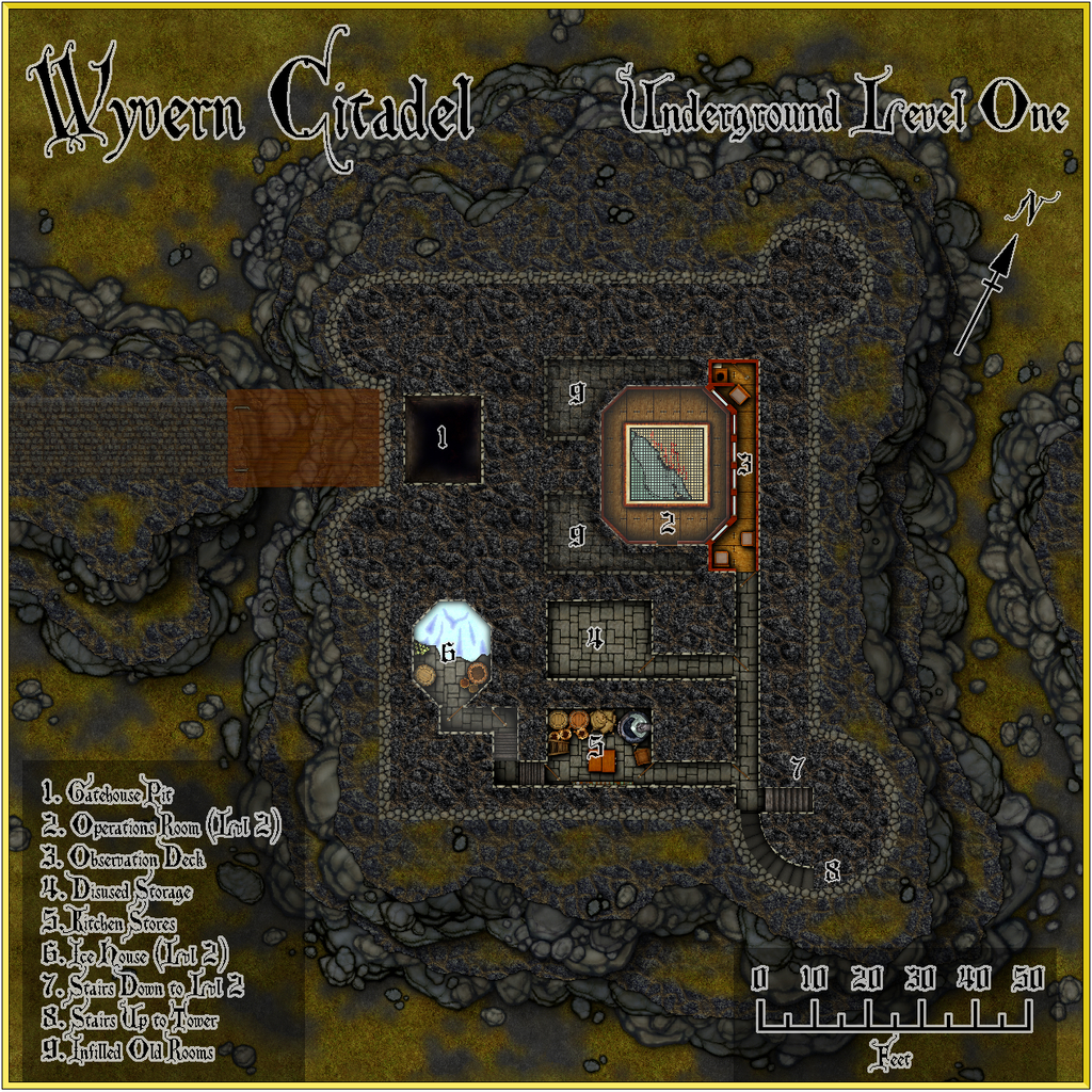
I wanted to show how the early sub-surface structures related to the main castle, and this first underground level is somewhat complex anyway, so having lightened the backdrop for the upper levels, I thought darkening it here made sense for going below ground, and turning the solid castle features ghostly, as they're really only for illustrative purposes now. Rooms 2 and 6 (and 6's connecting passageway) are actually on the level below this one. However, the windows in the Observation Deck look directly down to the table in the Operations Room, so both of those had to be shown together, after which adding the Ice House too seemed a natural follow-on. I did a pale fade over both though. The Gatehouse Pit drops another ten feet to its spiked base on the next level down as well, but I opted to use the nicely darkened pit from the Jon Roberts style here to suggest that. The switch back to the DD3 spiked pit base should be on the second level down.
As the two "dead" rooms 9 might hint, the construction of the upper part of Room 2 was relatively recent, and based on its lower level footprint. This will also lead into the much deeper, and rather different, third level down.
This is the first Community Atlas mapping project I've not really used any random design systems for (there will be a small element of that in the write-up for the earlier Defence Zone map though). However, the Citadel has been designed using Dwarven Forge model layouts as noted earlier, albeit added-to and modified. The subterranean levels are also all going to be based on such designs, using their original dungeon models in this case. However, for the first two levels down, I've had to reduce the size of the original plans by half, as they were too large to fit under the castle! In reality, this would be crazy of course, given digging out a dungeon takes far more effort than building a castle on the surface. While the plans I used were from the original plan booklets sent with some of the dungeon model sets, the third level down is a revision of a CC3 map I constructed back in early 2014, which itself was copied from the hand-drawn originals I made when I laid out the actual model design for real back in 2005! For that level, I'm holding to the original scale sizes, as we may eventually get to see, if I ever get back to mapping it! So, enough for now, I think!
![[Deleted User]](https://secure.gravatar.com/avatar/c75d9a245b74d9c59be0999ea81ca541/?default=https%3A%2F%2Fvanillicon.com%2F92add7f8c954488718110edc4896ad39_200.png&rating=g&size=200)


-
Community Atlas 500th Map Competition Results
I wanted to add my thanks also to PF and JimP for providing the prizes here.
I also wanted to add that though it was my good fortune to be awarded the 500th Atlas map thanks to the random draw, the Atlas wouldn't have reached this milestone without the input from large numbers of other people, many of whom have contributed far more to the Atlas project overall than myself (with a special mention for Remy Monsen as not simply being a mapping contributor, but for the huge amount of work he's put in to setting up and maintaining the entire Atlas website as well). It really is and has been a Community enterprise throughout. I hope those here new to the Atlas, as well as those who've already submitted any maps to it, will feel inspired to keep on contributing towards the next 500 maps and beyond!


-
Community Atlas 500th Map Competition Results
Congratulations everyone! Some very fine efforts here indeed, and worthy winners all in the voted-for categories.


-
Community Atlas: Wyvern Citadel Defence Zone on Kentoria
Had a bit of a rethink on the internal castle grid option today, and have tried switching to just white for the grid lines with a medium Transparency Effect. This is the Ground Level view with it on:
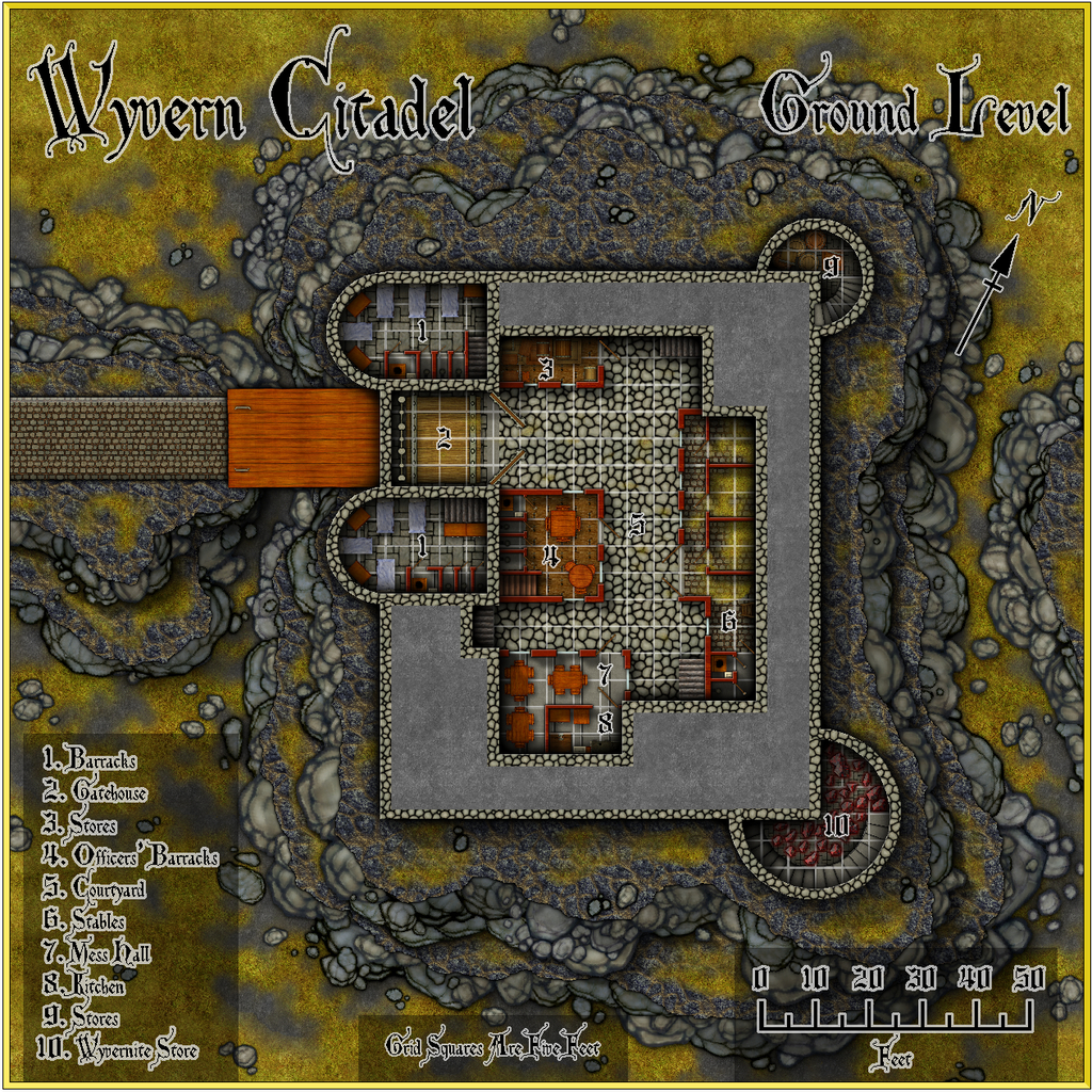
This seems clearer overall I think (and also on some of the other castle levels), and doesn't give quite the same impression of not being in-focus as the black with pale glow version earlier.
And as something fresh, this is the Third Level with no grids:
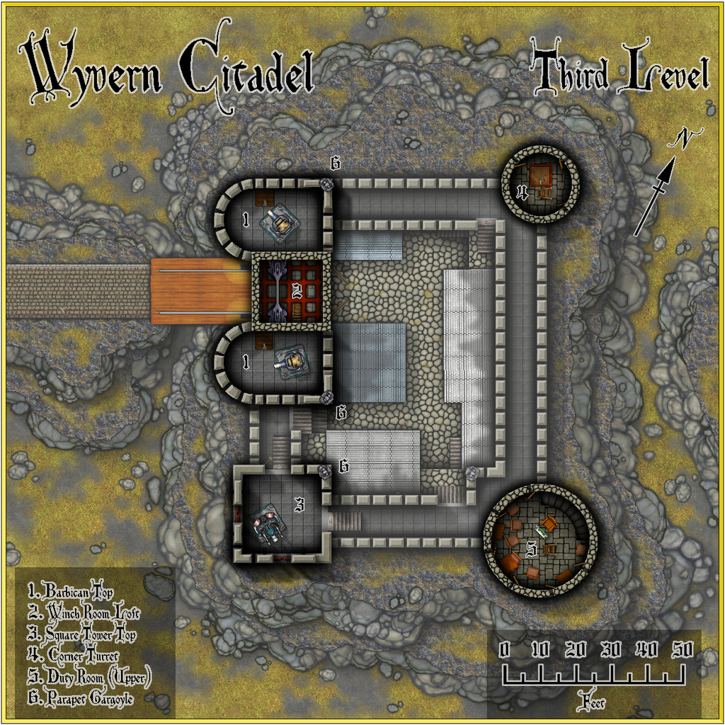
The Winch Room loft has no solid floor, just foot-wide beams, as it's only used to access the winch machinery when needed. The ladder continues up to the gatehouse roof through the beam-lattice.
Cos3 symbols to work the drawbridge and in a couple of other places, plus the first of the famed Strickfaden Lightning Cannons on the barbican and square tower roofs, the Mark I (on the square tower) and Mark III. If you peer closely, you might spot some murder-holes near the outer parapet walls of the square tower roof. They're sized to fit the original Dwarven Forge castle model, but you can barely see them even on the original CC3+ drawing from a distance. Actual shooting slots like this weren't often large either however, so this is realistic. There are also pierced shooting slits through two of the square tower walls (each is above one of the murder holes), and at the raised backs of the two barbican towers, while the square tower has pivoting wooden panels in the broader gaps in the wall, each of which also has a central shooting slit! More holes than stonework, you start to feel!
Of course, it's these complex wall piercings and additions which have taken up so much time on these upper levels. There are six Sheets just to create these outer walls, because the bevelled wall-tops have to be separated from one another to avoid the Effects clashing and spoiling the illusion.
More still to come though...
-
Community Atlas: Wyvern Citadel Defence Zone on Kentoria
About time for another update, I think. It's been a bit of a battle over recent days with others of the upper levels for this fortress, however, and I seem to have to keep going back and forth between maps to make amendments on those just "finished" still. I also wanted to put a grid on the areas belonging to each level, but that's proven difficult too, trying to get to something which is legible, yet not too off-putting. This is the Ground Level map again (as above), but with its grid:

The main snag is getting something that doesn't just vanish into part of the background floor texture. I've tried different glow colours, and grid colours, and this is about the "best" I've managed so far. I decided too to give the option of a whole-map grid as an alternative, but at a 10-foot square scaling, although that's just in the ordinary map-grid fill styling:
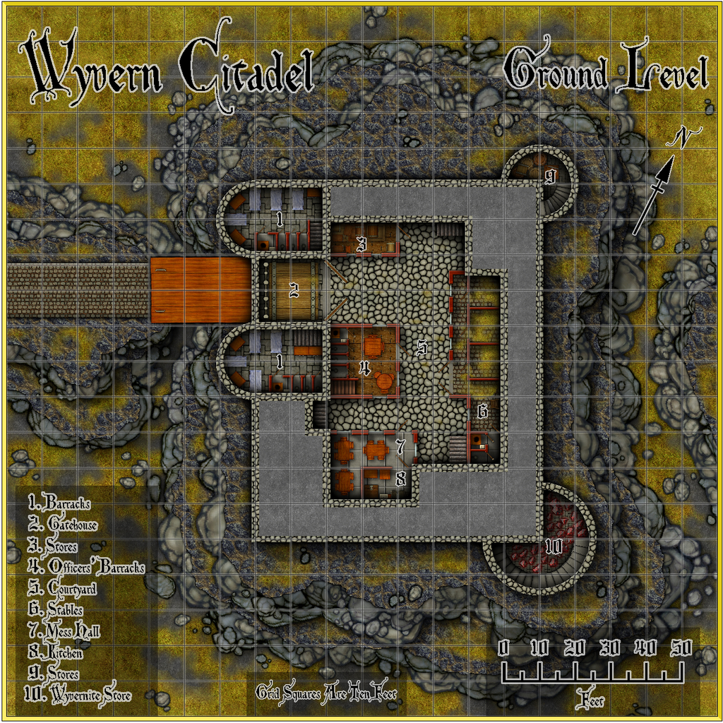
Here too, it's obvious this works better in some places than others. Overall, I've come to think that leaving things as they are, and giving Atlas users the option to toggle either grid on or off, leaving the grids themselves as items which can be adjusted in the FCW file should anyone wish to try, is perhaps the better option.
Better have something fresh now. This is the next level up, imaginatively called the First Level:
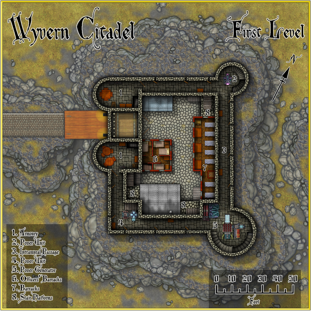
Each vertical level is about ten feet high, three metres or so. The courtyard buildings are essentially lean-to structures, using the stone castle walls as their higher "back" wall as far as the roof slopes are concerned, so rainwater drains off only into the courtyard. As promised, there are also some Cos3 symbols scattered about in places here as well. Each old arrow slit in the walls has its own wooden hinged shutter inside, to theoretically keep out draughts. I felt leaving them ajar, like all the door symbols, helps make these features stand out a little better. And as many here may likely guess, the fading of everything below the current level was achieved simply with a white cover for the whole map fitted with a high Transparency Effect. Terrifying to open the file and find it's mostly blank without the Effects active, of course!
Onwards and upwards, the Second Level:

None of the courtyard buildings have more than two storeys, so are roofs only from here on up. However, we also have the first open-air walkways along the top of the main castle walls now, and as you'll see, I've added a deliberately heavier dark glow around these "outdoor" elements to help separate them from those places that are still enclosed. It was a little tricky to work out how best to do this, as the shadows from the various different Sheet elements sometimes don't work to best advantage in such circumstances (when you really want them to be able to go under OR over some things they're adjacent to at times!). A few more Cos3 symbols here as well.
The Winch Room (3) is a bit complex, as the drawbridge winch cables have always had to drop vertically from the next level up to the roller shown here (or its older version, anyway - this one's a bit more high-magic-tech), and then out through the holes in the wall. All so as not to snag the old system for raising and lowering the portcullis. That's been simplified to a pair of devices worked by electrickery now though, that only need fastening to the side walls! There are classic "murder holes" in the floor of the Winch Room too, to allow shooting down onto any foes that have got as far as into the Gatehouse beneath it, and that's an especially long ladder on its south wall, as it goes up through the suspended ceiling of said Winch Room, and on up to the tower roof on the Fourth Level.
Plus a handy Jon Roberts style gargoyle/statue for the parapet. There are more of these to come. Wyverns might have been better, but I haven't managed to find any suitable as statues in a compatible style till now.
Two more upper levels to finish, and then the underground...


