


Wyvern
Wyvern
About
- Username
- Wyvern
- Joined
- Visits
- 3,266
- Last Active
- Roles
- Member
- Points
- 5,584
- Rank
- Cartographer
- Badges
- 24
Latest Images


-
Community Atlas: The Hall of the Seer, Glaciär Kristol, Ezrute
Somehow, I've seemed always to distract myself away from the primary focus of this sort-of Dungeon24 project, which was meant to be simply mapping small, underground complexes for the Atlas regularly and quickly (ha!) through the year. This latest item, the last of the four based on the random rolls from the "Explorer" dice set in the Inkwell Ideas Dungeonmorph Dice range, is a case in point. One little subterranean map has grown into three - a surface region, a settlement and the underground complex. Or "under-ice" complex as it became.
The latter does make it seasonal for northern hemisphere readers here, at least, strange in itself, given the location was determined almost a year ago now, quite randomly. That site was to be in the Glaciär Kristol region, the heart of Nibirum's small, frozen, southern continent of Ezrute:

When I checked the area map, I discovered quite a number of places had already been developed there, mostly towards its periphery. Examining those, none quite fitted what I had in mind for this small complex, which - in-keeping with the other "Explorer" dice-based maps - was to be tied-in with ideas from the Shadowdark RPG. One of the supplementary 'zines published by The Arcane Library for Shadowdark, "Cursed Scroll #3: Midnight Sun", deals with fantasy-Scandinavian-style sea-borne raiders, peoples and places, from which I took the concept of an oracular seer as the base theme for this Dungeonmorph map. And since everyone else had so kindly left the central area of the regional map unexplored, I picked a suitable spot by a crossroads there for this "Hall of the Seer" one:

I've reduced one of the effects on the roads in this image, since at the normal Forum resolution, the lesser trails especially simply vanished. That little orange square is six miles per side, and based on how other maps in this region had been tackled, I thought initially simply to place the dungeon map there with no others to zoom-in step by step. However, ideas had developed around this map by then which wouldn't let me alone, hence how I decided on an overland area map, with a small settlement by the underground complex as well.
Partly this development came from the region's location. The Hall map is at roughly 72°S latitude, which puts it well inside Nibirum's Antarctic zone, with constant daytime in midsummer, constant night at midwinter. When I checked the geomagnetic map for Nibirum, I realised this spot also lay almost directly under the midline of the southern polar auroral zone (I've highlighted central Ezrute with an orange ring here):

That means those winter nights aren't always so dark as might be thought, with frequent auroral events to brighten the landscape a little - and spread their magical influence over the surface too, of course.
Looking over the written notes for a couple of the existing maps in this area that had them suggested the possibility of more unusual elements at play nearby, which fed into the base-map designs for all three in my small group, where ideas sparked by one map bounced into the others.
For the first map, covering that six-mile square, there was a mild complication, since I wanted to continue the black-and-white hex-map style I'd used previously in these "Explorer"-design-inspired map sets. Only being hexes, that meant the area was best-served by a map six by seven one-mile hexes in size... Random rolls on tables from "Into the Wild - Omnibus Edition" by Third Kingdom Games, as used previously in the Barrows of the Ferine Magi maps, coupled with some from Shadowdark and Cursed Scroll #3 followed, in setting up the contents for hexes within the area, after which the mapping could proceed:

This time, I decided to let the terrain spill out for another couple of miles beyond the hex-mapped zone, to allow for better context, and also to make the labelling clearer, without cluttering the centrally-mapped part. Could not quite believe the random rolls had generated two ley lines in such a small place, as they're not that common to roll-up. They did fit perfectly with what I had in mind from the extra-magical auroral effects hereabouts, however.
The map description notes have details on what's where, although I deliberately scaled-back on the significance and size of many features, to better suit this little area. There's an old temple with guarded treasures that nobody here knows about in hex 001, minor terrain oddities sprinkled here and there (including a sheltered vale where the mammoths like to hunker-down when the weather turns bad - hex 104 - and where arctic smilodons come a-hunting!), a small frost giant homestead in hex 101, and Seer's Hall Village in hex 204, which enjoys a milder microclimate thanks to being in the fringes of the small Redwoods forest, on whose northern side is the great 200 ft (60 m) ice tree Ylvabrand (hex 302). There are some ancient, worn statues along the Skorra Road in hex 502, commemorating an ancient battle nobody now recalls (which weirdly ended-up randomly in the very spot the road and ley line almost converge), Ice Kraken Hill, where the ley line nexus is (yes, that's a living, albino kraken in an ice hill right there; favoured as a deity by a secretive cult, naturally 😉), a crevasse in hex 605 in whose depths the temperature somehow holds-up around 20°C (70°F) year-round, shunned by the locals because a group of buried Dwarfs there have become undead Ice Zombies or Draugr, who can swim through frozen ground and rock as if it were water (luckily, they can't abide the ley lines), and what seems to be an oval ring of granite menhirs on the line of one ley line in hex 606, that are really upstanding pieces of granite from a ring-shaped surface outcrop in actuality, all of which seemed suitably odd.
Fun times! Village map next.


-
Looking for Symbols
I remembered this because I used it a long while back (shown in the first post in that link) to make versions of Nibirum for the Community Atlas!
-
Community Atlas: Barrows of the Ferine Magi area, Feralwood Forest, Alarius
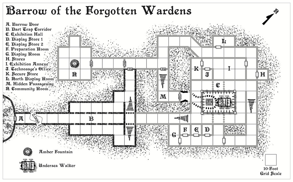
The last of this, as it turned out, quartet of maps from the heart of the Feralwood Forest region in Alarius, is for the Barrow of the Forgotten Wardens. The layout, of course, is more or less identical to the previous "Noble Jewels" Barrow, except this one has no lights inside, and two of the hidden Transdimensional Passageways are in slightly different places:
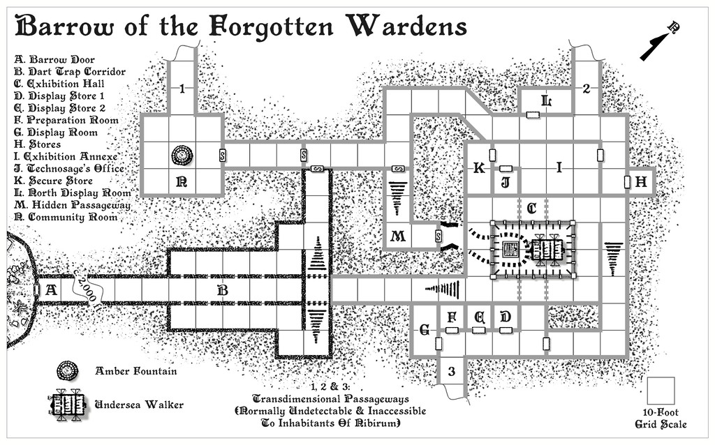
It was a little curious that there turned out to be three random exits selected for each of the Barrow maps, and that there was some duplication between the trio for where those exits were. I did consider changing them up for more variety, but in the end decided to let randomness have its way.
I reused the glass-panel railing for the pit section of area C from Noble Jewels, although here the railing is just a metre, 3 feet, high, leaving the central area fully open to the lower level. There are also a couple of new features here, both larger techno-magical items. The Undersea Walker is a vehicle adapted from the Hyperborea RPG. In the accompanying text notes, and as originally intended on the drawing, it partly hides the floor trapdoor on the lower level of area C. However, that wasn't practical on the map for clarity. The Amber Fountain, drawn from the Numenera RPG, is a main food source for the external community not represented on the map, on the world outside that isn't Nibirum, and for which the first Transdimensional Passageway provided a useful choice for its location.
Internally, this layout is essentially an ancient museum, so there are display cabinets with all manner of items extracted from both Numenera and Hyperborea in them, most still functional, if anyone can work out how they operate without draining their power (one-shot items) or accidentally killing someone in finding out. To assist, there is a semi-resident Technosage from beyond Nibirum here, and the whole non-Nibirum section of the complex is surrounded by a functional loop of telepathy wire (also listed among the items from Noble Jewels), so the Nibirese may be able to communicate with her. Rho the Mysterion makes its third identical appearance here as well - another telepathic communicator - along with a couple of weirder denizens from outside Nibirum, as the map notes will reveal.
I've not added the PDF notes here this time, and have now also removed the earlier ones, as the final PDFs and textfiles have been submitted for the Atlas, which should hopefully avoid any confusion as to which version to prefer! I have though added higher-res versions for this map to my Gallery, and am now preparing to move on to the last of the four "Explorer" Dungeonmorph Dice designs in this project, which is scheduled for a home somewhere in the Glaciär Kristol region of Ezrute...


-
Community Atlas: Barrows of the Ferine Magi area, Feralwood Forest, Alarius
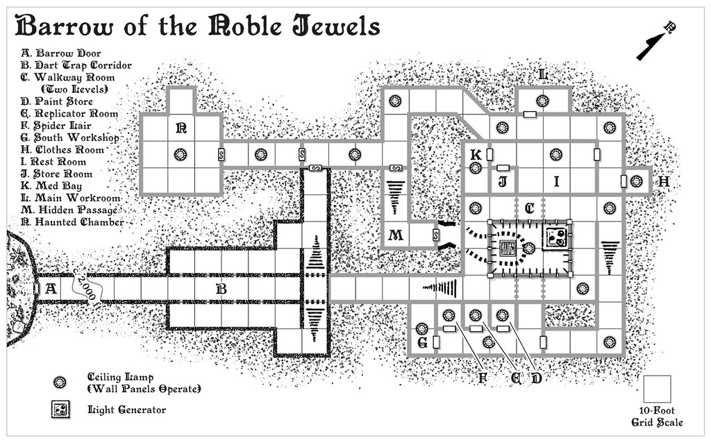
A little quicker this time, as the second Barrow map, for the Barrow of the Noble Jewels, had already had much of its layout prepared in advance through last time's "Emerald Guardians" one. This is its "normal" view:
While this is the view with the non-Nibirum passageways revealed:
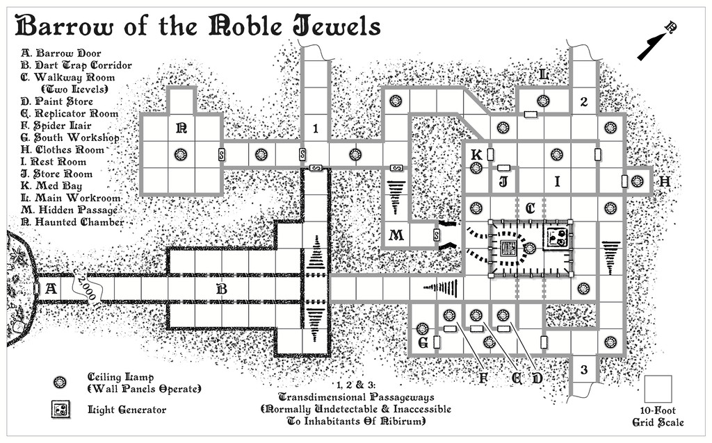
There was a degree of copying and pasting of items over from "Emerald Guardians" here, including where things had changed since the base map for all three of these designs was laid-out, although I retained the original non-Nibirum wall-line colouring here, as not needing to add the pneumatic tube lines for this map. The Ceiling Lamps are still present in this drawing though. While I did consider moving some about, that really didn't make any sense, as they shed light over a limited area, and with only 20 Lamps to play with, that had already restricted the options in the previous map anyway. I did try to make the exterior sliver on the far left map edge look a little different, and I changed up the look of the railings around the lower level pit in area C, as here, they're meant to be floor-to-ceiling glass or crystal panes, with metal frames, isolating the lower level from the upper walkway completely.
In terms of the contents, most derived from Numenera again, with items and inhabitants both randomly chosen and distributed, although the identical Mysterion makes another appearance, something which, while unstated, gives GMs the opportunity to make things still more weird for visitors from Nibirum who have already met this character previously. There are curious others here as well, including a couple of sort-of, yet not undead, "ghosts", and a superstitious Human Crafter of technology (he's living in a haunted workshop, as he believes it, after all!). Possibly the deadliest creatures are three living-steel spiders, whose web-strands are essentially monomolecular steel threads. They've been set up so opening the door into the chamber they're in will slice off part of the metal door without slowing it, as a warning...
One more of these identical dungeon layouts to come!
[EDIT 19 November 2024: Although I originally added the provisional PDF description for the map to this post, I've removed it now, as the final version has been submitted for the Atlas!]


-
Community Atlas: Barrows of the Ferine Magi area, Feralwood Forest, Alarius
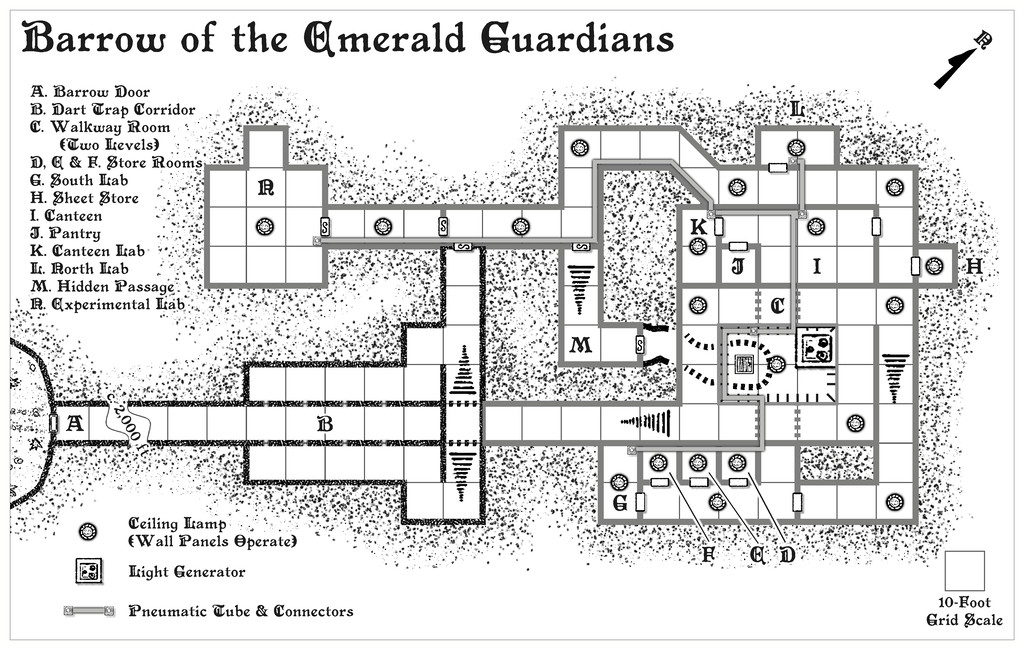
Well, that was a longer break than I'd anticipated. However, I can now update progress with this project today, having completed the first map, for the Barrow of the Emerald Guardians, and its notes. Typically, if unintentionally, along with other RL issues this month has brought so far, this first map was also the more complicated of the trio to prepare, as it had been randomly assigned both a light generator and lamps, and a pneumatic tube communications system, both of which needed adding to the map. The lamps and generator were straightforward enough, as simple individual fixtures. The pneumatic tubes though needed drawing-in as well, however, given each is meant to be about a foot, 30 cm, in pipe cross-sectional diameter. Lines are, of course, simple enough to draw onto a CC3+ map, but getting the colouring to work well enough in greyscale turned into a bit more of a challenge, and ultimately, I opted for a thin, dark outlining glow effect as well to get the tubes to stand out without making the walls seem like irrelevances. Plus the wall colouring had to be changed as well (several times, in fact, though that doesn't show here, of course...).
This then is the (probably, subject to later checking) final map in its "ordinary Nibirran" view:
And this is the view with the hidden passages those not from Nibirum can ordinarily see, displayed:
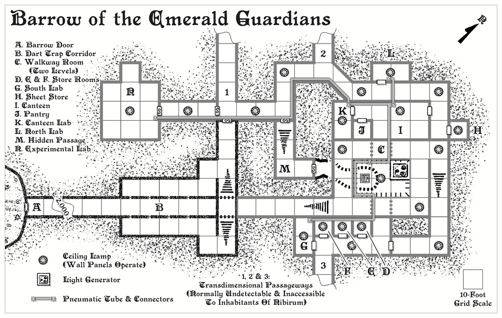
In terms of map contents and denizens/potential denizens, these were drawn, and then adapted, from, primarily, the Numenera RPG for this map. In the notes, I've identified the original source object or creature type, in case anyone should want to use the "standard" versions instead of my amended ones, for which I've also provided Shadowdark stats and comments. We have a couple of Human inhabitants, both tech-savvy mage-like inventors of sorts, and a host of curious magic-like gadgets they may have constructed or be working on (or indeed, even be using). There are also oddities from the non-Nibirum world outside (since I've assumed there is a settlement of some sort beyond one or other of the "exit" passageways), creatures that have wandered, or may wander, in, including a particularly vicious group of vaguely humanoid, communal, raiders that communicate purely by telepathy, and which have a thick, long tentacle each instead of a head. There's also a wandering envoy, a loosely insect-like humanoid, jerky of motion, actually a technological construct, liable to be off-putting to folks, despite only wanting to establish peaceful contact with other humanoids. That one can summon a group of warriors of similar type should the need arise, since there seems the possibility for some curious alliances to form among the folks here when added-to by a group of Nibirran adventurers. And then there's also the Mysterion (as I've called it), essentially a Vorlon from the old Babylon 5 TV series, should you recall that. That one's going to be in all three of the Barrows, being extremely cryptical and enigmatic. I did promise weird!
Hopefully, not quite so long a gap till the next map's ready from this trio.
[EDIT 19 November 2024: Although I originally added the provisional PDF description for the map to this post, I've removed it now, as the final version has been submitted for the Atlas!]

