


Wyvern
Wyvern
About
- Username
- Wyvern
- Joined
- Visits
- 3,303
- Last Active
- Roles
- Member
- Points
- 5,647
- Rank
- Cartographer
- Badges
- 24
Latest Images


-
trace map aligning to grid
For scaling, the option I use is the drop-down menu command: Info => Distance. Make sure "Ortho" is active, but that "Snap" is off (buttons at the lower right of the CC3+ window), and zoom-in so you can see the grid squares on your image very clearly.
Then use the Distance command to measure the separation between the horizontal and vertical grid lines for a single square. "Ortho" will ensure you're only able to measure in the true vertical or true horizontal directions. (Although both should be the same, sometimes a minor distortion in the map image, especially if it's been scanned, means they're not exactly equal, and your own by-eye estimates can be a few pixels, or more if you're me, out as well.)
That will give you an overall value in map units (feet or metres for dungeon-scale maps, depending on which option you're mapping with) for the size of the grid squares on your image. If that doesn't match with the size of the snap-grid squares in your CC3+ map, then yes, you'll need to rescale the image.
To do this, use the :CC2SCALE: command (button to the mid-left side of the CC3+ window). Click the button, select the image using one edge of it that's free from other entities in your drawing, then click "Do it".
The Command Line will ask you to pick a scale origin (I often use the bottom left corner of the image, but pick whatever point seems best to you), and then it asks "Scale to" with a couple of further prompts. The easiest option here though, is simply to type in the value of the image's grid size, as just measured, and the size you need it to be, the two values separated by either the multiply or divide keyboard options, as appropriate. For example, if the image's grid is showing as 9.4 feet and it should be 10 feet, use 10/9.4 to make your image larger (if you get it wrong, just use the :CC2UNDO: command!).
Then check using the Distance command again, to see if this is now the correct size (or closer to it - sometimes, because of the decimal places involved, it won't be exact, but close enough is usually good enough, though you may need to adjust your CC3+ drawing in places to accommodate any differences). If it's still some way off, just use the Scale command again.
Good luck and good mapping!


-
Community Atlas: Temple of Nidag, Stormwatch, Emerald Crown Forest, Alarius
For the next map in my ongoing Atlas project, I thought it might be interesting to try another work-in-progress topic, to show some of the developments as they happened along the way. It's been a while since I last tried this, and I do tend to forget to record progress while mapping, but we'll see how it goes! The initial posts below, over the coming days, will outline what's happened to get this map underway during the last couple of months, and only the subsequent notes will start to become rather more immediate.
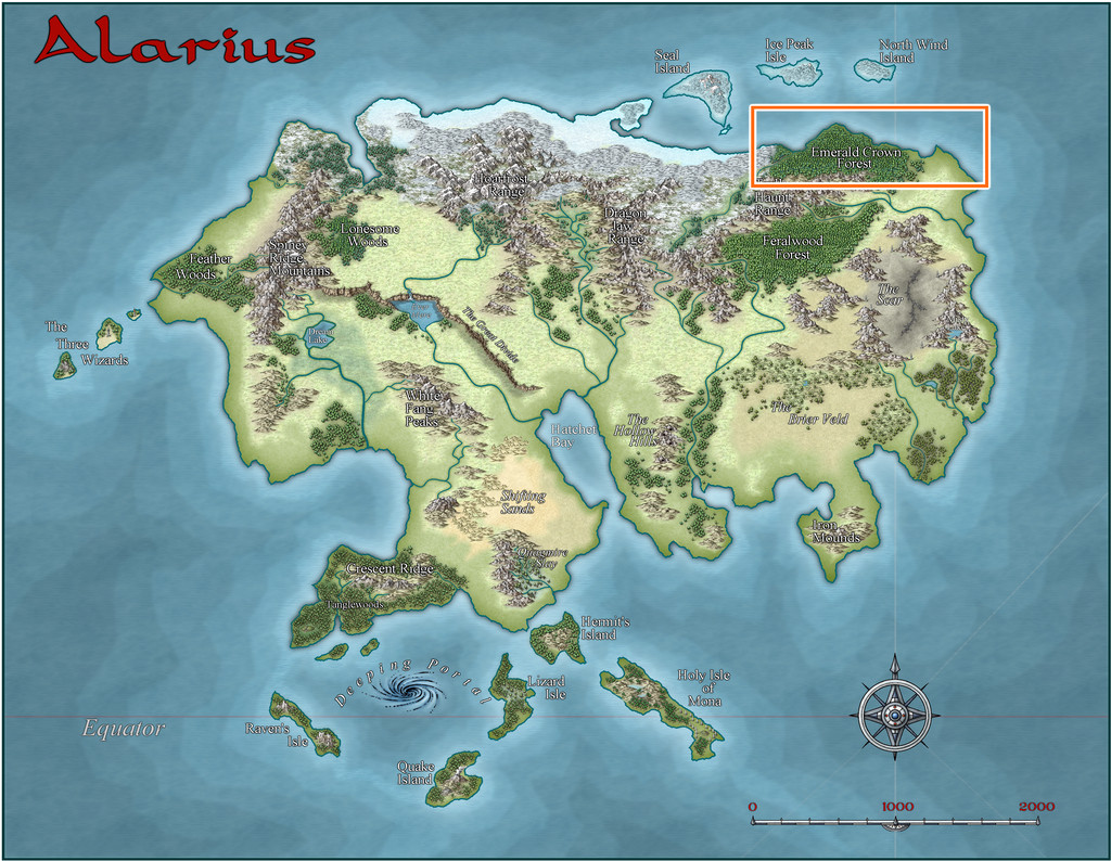
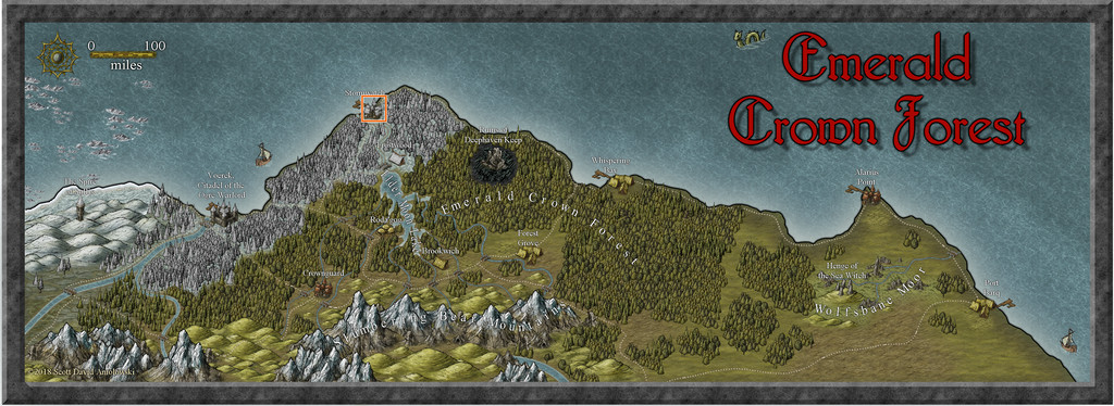
Said map was intended for somewhere in the Emerald Crown Forest region of northeastern Alarius, here:
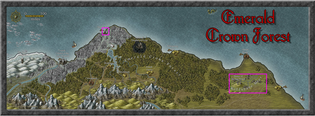
Zooming-in to the next map already in the Atlas, there were a couple of additional places already mapped (highlighted in pink), along with some equally intriguing unmapped spots:
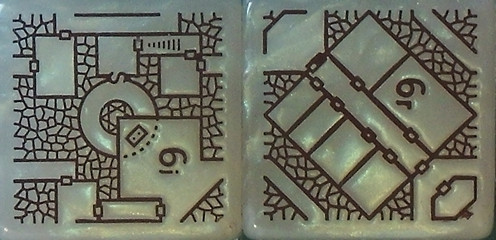
As usual, the development of each new map in this project is an organic process, in that while thinking about where the map's to go, I'm also looking at the dungeon design, and identifying ideas for what its contents and purpose might be. In this case, the design was from two Inkwell Ideas Dungeonmorph Dice in the Trailblazer set:
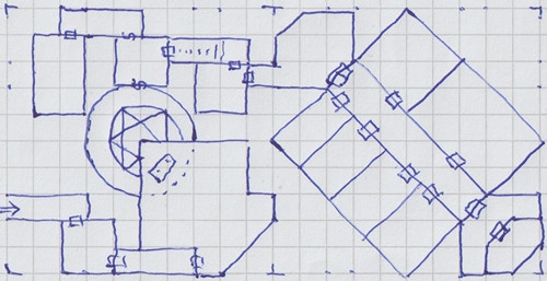
These translated into my hand-scrawled version, with the unconnected/extraneous passages and areas either removed or adapted, thus:
Looking through the Inkwell book that accompanies the dice for this pair of designs, the 6i one is from the Incantations/Magic Areas die, whose main-idea notes suggested this to be a temple masquerading as for a good/neutral deity, but which was actually for another less pleasant one - so that altar above the circular room drops victims down into it, for use in summoning an avatar of the deity, for instance.
The 6r die's main notes (for Rooms/General Areas), proposed it as part of the private quarters for some royalty, with a kitchen, dining room, and guards, while one of the alternative suggestions was for it to be an inn, possibly one with several vertical levels. In combination, these suggested a temple complex (replacing royalty with priests and inner-cabal followers), partly above ground, partly below. That suggested a larger population would be needed to both support and conceal such a place, as well as to provide victims for use in the summoning chamber.
Turning then to a couple of further books for inspiration, the "Tome of Adventure Design", and the very recently-released "Nomicon", both published by Mythmere Games, provided Maleng, Herald of the Seasons as the beneficent nature deity for the temple, with the congregation ostensibly calling themselves The Fellowship of Maleng, although they're really The Fellowship of Nidag, The Blind Slayer (the deity who's not so pleasant).
Looking at settlements in the Emerald Crown Forest area after this naturally pushed my thoughts towards the larger towns, and likely towards those on the coast, as probably having sizeable itinerant populations, where people chosen as victims would be less missed. Which eventually brought me to the pre-mapped town of Stormwatch:
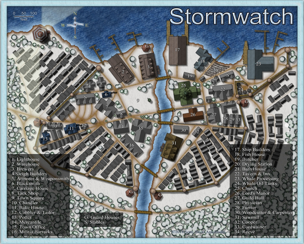
It's probably not hard to see what drew me here - there are lots of anonymous groups of houses of the right size and rough orientation to fit the dungeon dice designs quite well. Finally, I picked a spot on the eastern edge of the map, outside the town walls, here:
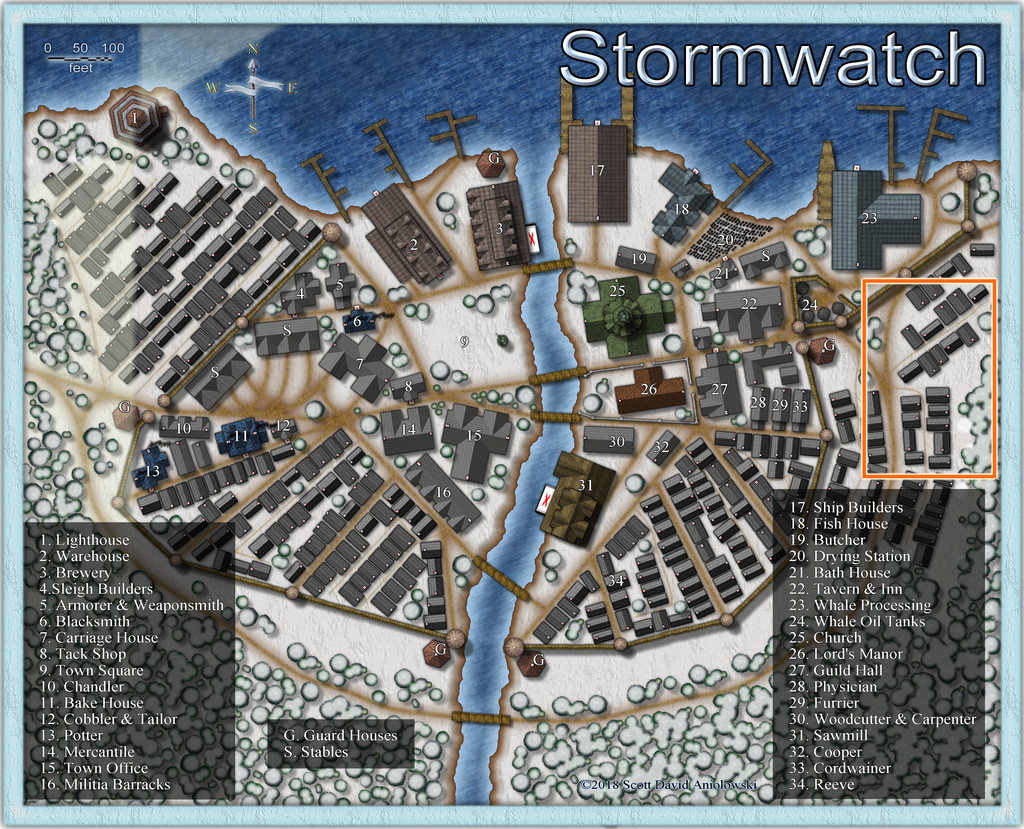
At which point we discover I was missing a few small symbols (probably from the free, non-ProFantasy, sets usable in the Atlas) - for the inn signs, chimneys and waterwheels - hence the red Xs in places (the previous shot of Stormwatch was taken from the hi-res Atlas version).
Choosing that area wasn't straightforward, however, because a swift test-trial of my hand-drawn dice design showed the fit wasn't going to be exact, either from the placement and sizes of the various buildings, or the angle between the two main parts of the design. This wasn't unexpected, and after checking several potential alternatives, the orange rectangle on the image just above was picked as the closer fit. Even then, that area wasn't properly defined at this point.
I narrowed the spot down by setting-up a basic line drawing in CC3+, where I could compare the exact shapes, sizes and orientations of the Stormwatch buildings with the dice design draft map. This began by extracting those forms from the Stormwatch map thus:
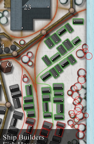
The building outlines were generated more or less automatically, by simply copying the buildings to a new sheet and layer, and changing their properties (possible only because they were originally created using the CD3 house-drawing tool), while the tree circles and road lines were all hand-drawn. The two colours are because the original test-fitting was done just with the green-outlined buildings, and took several attempts. The red outlining was to make sure all the features in the final rectangular map area would be covered too, once the final "green" selection was made. Next time, pinning-down that rectangle.


-
Ricko's Questions
Try this advice post on getting bitmap fills into your current drawing.
-
Live Mapping: Cosmographer System Map *** NEW second attempt ***
That went well then! What is it about the times I manage to get along to the livestreams, they die on us all?! I'll be getting a reputation at this rate...
[And for anyone puzzled, the stream had to be cancelled after starting, as Ralf couldn't get his router to behave.]

-
Does anybody have a collection of Character Artist symbol libraries?
The old ProFantasy Map & Symbol Library of user content still exists, at least partially, but it's difficult to find, as although there are some surviving links to it on the Forum, there isn't a direct link from the main PF website any longer.
You can find it here though, although you will need to then search for what you're after (and you may need to be creative with what keywords you choose - see for instance this topic from 2022 on the subject). Using "Character Artist" today, for example, brought up 30 files, but only about ten of those seemed to have body-part catalogues - though I didn't check all in detail.
Based on that 2022 discussion, I don't think any of the active contributors commenting there had anything like a full collection of downloads. JimP from it is sadly no longer with us, while the topic's instigator hasn't been back to the Forum since early 2022.
We've asked hopefully for more materials for Character Artist over the years, but because it's very much a minor add-on to the main software's mapping aims, that's never happened, and we suspect probably never will happen (although with CC4 well in the works now, a Character Artist 4 might be a distant (pipe-?)dream, mayhap).


