WeathermanSweden
WeathermanSweden
About
- Username
- WeathermanSweden
- Joined
- Visits
- 3,755
- Last Active
- Roles
- Member
- Points
- 459
- Location
- South of Lübeck in northern Germany
- Website
- https://www.astroinfo.se
- Real Name
- André Franke
- Rank
- Surveyor
- Badges
- 6
Latest Images
Reactions
-
Help exporting view from FT3+ to CC3+
Why the exported colours in exported CC3 maps do not match the colours shown in FT3(+) is discussed here:
Greetings,
André
This CC3+ map has been exported from FT3+ with 200m height contours using the method described in the article above.


-
FT3 and CC3+ colouring
Have you downloaded the file that is linked in the article (mentioned by Sue above)? It is the same file that I have attached to this message.
The file contains one export file for FT3, namely
32 ColContours -32.000 ft 32.0000 ft.xptwhich can be found in the XPT folder. The file has to be copied to the Export folder (found in ProgramData\Profantasy\FT3\).In the PAL folder you will find several .pal files which have to be copied into the Palettes folder (found in ProgramData\Profantasy\CC3Plus). I recommend to create a new subfolder in the Palettes folder e.g. "32col" and place all the files in there.
Then export your mat from FT3 by using the new export-file, then load the map into CC3+ and load one of the new colour palettes as described in the article.

-
Importing jpg maps into FT3+
The height values of the original data is in meters as well as in the .mdr file for FT3.
I had a quick look at the original dataset you have used for generating your map and it contains erroneous height values up to 10.200 meters that are kept even after conversion to a .mdr file (my program assumes that the original dataset has no errors...). This leads to the effect that you described - that all heights seem to be coloured in a lower level colour (the map looks greener than it should look like).
To get rid of the erroneous heights I loaded the .mdr file into Wilbur (http://www.fracterra.com/wilbur.html) and searched for all heights above 5000 meters and replaced them with the value -5.200 meters which gave a satisfying result. Then I loaded the corrected .mdr file into FT3+ and made an export using Jerion style. But this style is optimised for feets so you have to change the world settings to feet before exporting.
The result in FT3 looks like this:
The result in CC3+ (the colour ramp ist optimised for data up to 30.000 feet but the highest mountains are only about the halv of that height...:
and the belonging FCW is attached.
That the height colours do not match exactly is in my opinion due to the two different setups - one for the colouring of the FT3 map and another for the export.
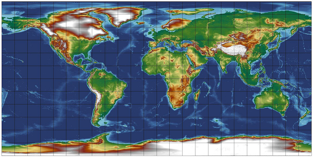
To get a little more dramatic map of the world I used the global math tool in FT3+ and multiplied all heights by the factor 2. The result in FT3+ looks a little strange, but the exported FCW for CC3+ looks quite realistic.
I only post the CC3+ result here:
and the belonging FCW:
Keep in mind that the heights in the legend are wrong by the factor 2 now...the must be corrected manually....
As you mentioned when you zoom in a map in FT3+ you always have more details as when you do it in CC3+. That is because of the simplifications that have to been made when converting gridded height data into vector lines.

![[Deleted User]](https://secure.gravatar.com/avatar/c75d9a245b74d9c59be0999ea81ca541/?default=https%3A%2F%2Fvanillicon.com%2F92add7f8c954488718110edc4896ad39_200.png&rating=g&size=200)
-
Importing jpg maps into FT3+
This tutorial shows you how to get all height data from paleo maps into FT3(+)
-
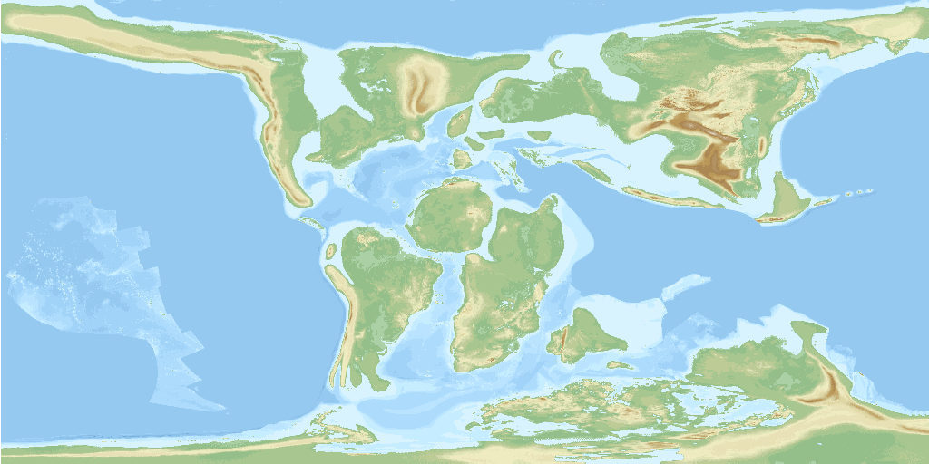
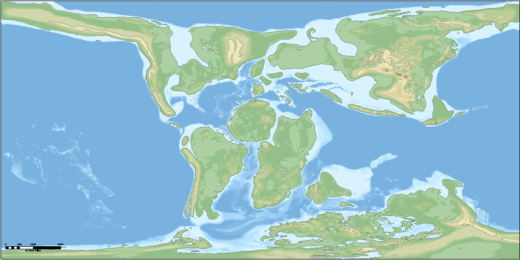
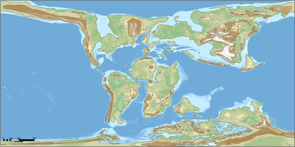
Northern Europe 15.000 before present - how it might have looked like...
As soon as my MDR-converter is more user-friendly I will write a short tutorial as I did for the Paleo-maps.
I also plan to describe the data provided by the authors a little more in detail and some of the problems I ran into when using the data.
This is a great source for everyone who ever wanted to get "real" elevation data for the ice age - though we never will know exactly what our earth looked like plenty thousands of years ago...
Meanwhile - here is what the whole world might have looked like about 15.000 years before present: