Monsen
Monsen
About
- Username
- Monsen
- Joined
- Visits
- 723
- Last Active
- Roles
- Administrator
- Points
- 9,011
- Birthday
- May 14, 1976
- Location
- Bergen, Norway
- Website
- https://atlas.monsen.cc
- Real Name
- Remy Monsen
- Rank
- Cartographer
- Badges
- 27
-
Wishlist for CC4
Well, there can never be enough tutorials, but it is described in the Manual, which is a tutorial for the program. I know some people prefer videos instead of written word (that still boggles my mind, really), but videos do take time and effort to make (and are also way more difficult to keep up to date compared to written text). I do make video tutorials, but it is difficult to get to everything.
-
map borders
Sure. If you have them as an image file, just use Draw -> Insert file to insert it into the drawing (Note that CC3+ inserts a reference to the file, so if you later move or rename it, your map will display it as a missing image).
If it is a tiling texture, you can import it as a fill style from your map (Tools -> Import bitmap fill style or just create it manually from the fill style dialog) and you can then use it as a fill when drawing things like polygons.
-
Live Mapping: Cubing the Dungeon
-
NAN,NAN Problem
Here is a fixed version of the file. I've set it up with a 50' grid with 5 snaps.
Here's the exact steps to set up a reasonable grid:
- Right click the Snap button in the lower left.
- Hit the New button in the dialog to define a new grid
- Select 2d Rectangular as the grid type and hit continue
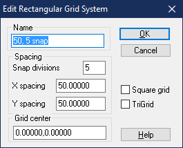
- You can name the new setting whatever you want, but it is best that it follows the actual settings, so I named mine "50, 5 snap". I then set the snap divisions to 5, and the X and Y spacing both to 50. What this ends up doing is making a snap grid that has a visible dot every 50 map units (feet), but it snaps every 10 feet. If you feel the the snaps are too fine grained, try setting the snap divisions to 2 instead, and if you have too few snap points, try with 10 for snap divisions.
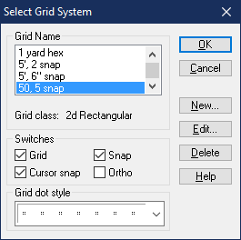
- Click ok, and then back in the select grid system dialog, scroll down and click on your newly created grid to select it, and then hit ok. This will make your new grid the active one. Save the map.
-
CC3 wont let me draw anything outside of a square that covers a small part of my map pls help
What happens here is that CC3+'s drawing tools are set to stop at the map border, and the map border itself is identified by entities on the MAP BORDER layer. What has happened here is that you have somehow gotten some extra entities on that layer, which basically redefines the map border.
Open up the layers dialog by clicking on the L: indicator in the status bar. Hide all layers except MAP BORDER. It should now be quite obvious which entities do not belong here. The map border itself should normally just be a thin outline around your map, there shouldn't be anything in the middle. Now either :CC2ERASE: the offending entities, or just use :CC2MCHANGE: to move them to another layer.


