Royal Scribe
Royal Scribe
About
- Username
- Royal Scribe
- Joined
- Visits
- 9,950
- Last Active
- Roles
- Member
- Points
- 3,488
- Birthday
- February 5, 1968
- Location
- San Francisco, California
- Website
- https://legacy.drivethrurpg.com/browse/pub/31814/Royal-Scribe-Imaginarium
- Real Name
- Kevin
- Rank
- Mapmaker
- Badges
- 16
Latest Images

Reactions
-
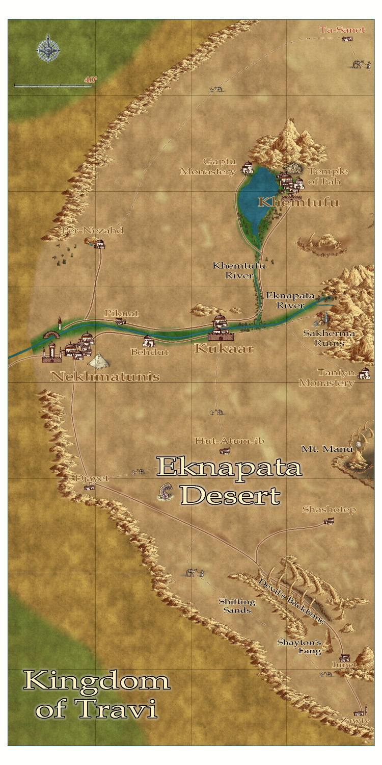
Community Atlas submissions: the Gold Coast (Doriant) and areas within it
I am ready to submit the FCW for the Eknapata Desert for the Atlas, knowing that it won't be processed until after the contest ends (though it is a parent map for a village I am submitting to the contest).

Here is the FCW, along with a PDF Description and a plain text file (with accents replaced with standard ASCII characters).


-
Are gift certificates available?
Last year, I asked about the availability of gift certificates (my very first post, actually), and it was suggested to buy what you want to gift and then instead of registering it, forward the email with the registration code to the recipient.
It's a good solution for those of us familiar with the site mechanics and know what we want to gift. It doesn't really work, though, if the buyer doesn't know what the recipient already has or would want to get, or if multiple people might want to gift something to the same recipient but were risking buying the same thing. (I am greedily thinking of myself as the recipient, and how people always ask me what I want...and how would I explain this process to folks who don't use ProFantasy?)
Anyway, I wanted to revive this idea well enough before the holidays to see if ProFantasy had the ability and resources (knowing that there are many priorities competing for scant time) of creating a gift certificate option.
Thank you!
-
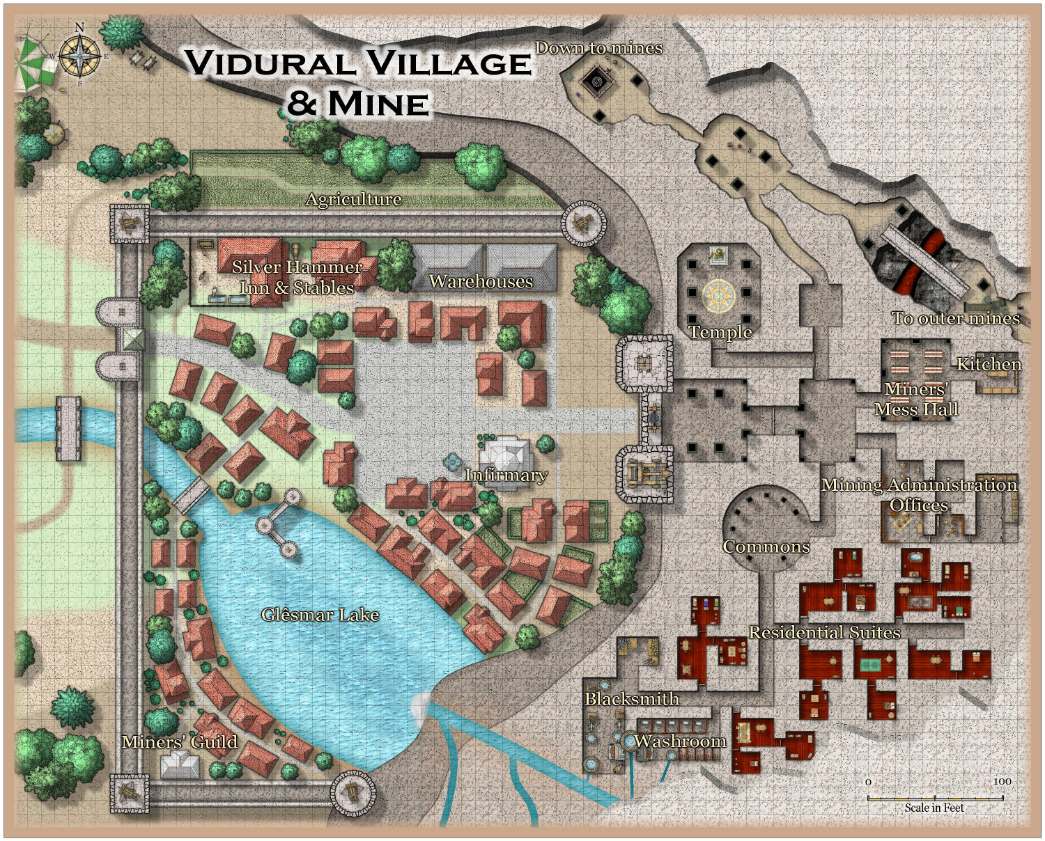
[WIP] Atlas Contest - Vildural Village & Mines
Having done (in varying stages of "in progress" and not all submitted yet) an elven farming village, forest village, and underwater village, as well as a desert town, what other unusual village environment could I tackle. How about...underground?
I decided to build out my dwarven kingdom in order to find a home for a dwarven mining village. It ended up being more above-ground than below. I did it in the Mike Schley style because it's compatible with Monsen's Mines.
The village is more fortified like a town, but I figured that was more to protect the mine, but it's still a small village.
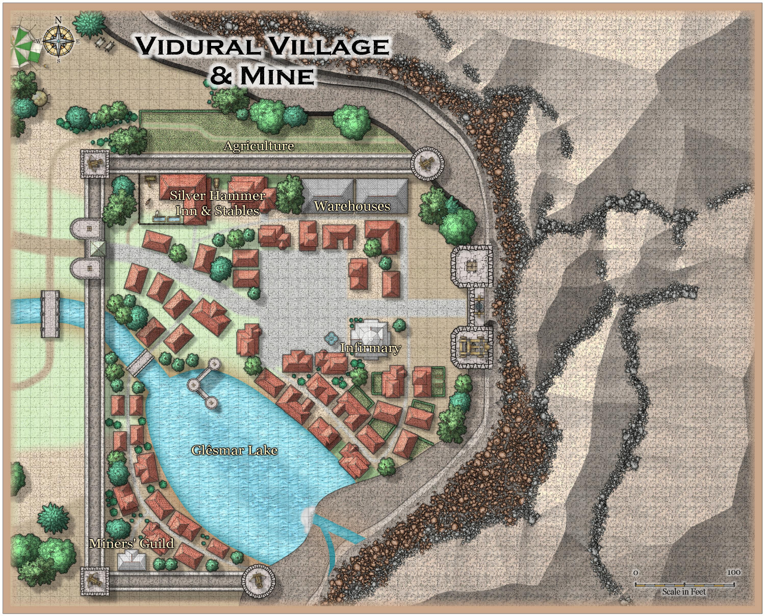
Villages don't usually have many specialized shops, so I didn't label any of the potential-retail buildings around the town square. There's a little bit of agriculture, and a few villagers have gardens, but most of the village's food is bought or traded with the wealth generated from the mines. Pretty much every family in the village has at least one family member who works in the mines, and anyone else who doesn't has some job that supports mine workers. The Miners' Guild is more like a union rather than a what we might think of as a guild, as it represents the workers rather than the mine's owners.
But no blacksmith in the village. That can be found in a (well-ventilated) space within the mines.
If we hide the "Roof" layer (that is, the top of the mountainside), we can peek into portions of the mine operations. (I still need to finish furnishing this area.) There's a temple used by the entire village, and a blacksmith. Miners can eat in the Miners' Mess Hall during the day, fed by those who work in the kitchens. There's a set of offices for the Mining Administration, where the mine's accounting and payroll are managed. One room has several locked cages to provide extra security for the mine's ore and treasury. In a pinch, it can also serve as the village jail. (One wonders if the mine administrators will come to regret putting the lockup in the treasury.) There's a washroom where miners can get cleaned up before going home, but it's mostly used by the dwarves who live underground.
The furnaces in the blacksmith's and next-door washroom also heats water. The dwarves have created a cunning pipe system throughout this level of the mines that brings both hot and cold water to the residential suites and the kitchen.
There are six luxury residential apartments underground. Most of the underground residents use the common washroom, but the Mine Administrator's family has their own private bathroom with bathtub.


 and 1 other.
 -
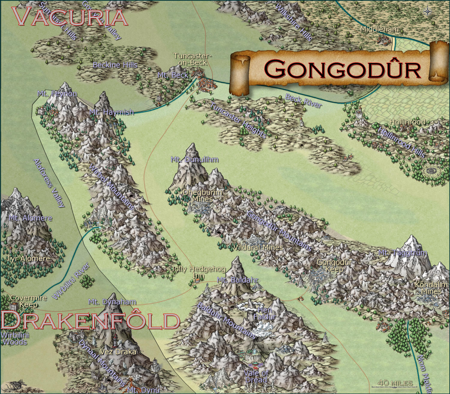
[WIP] Kingdom of Gongodûr
Here's a "work-in-progress" area map for the Kingdom of Gongodûr, a dwarven kingdom in the southeast corner of the Gold Coast area I've been working on (to provide a home for a dwarven mining village I'm working on). I used the Mike Schley Overland style because it has the best dwarven community symbols.
I shaded the countries outside of the borders of my dwarven kingdom, but not sure if that's the right approach. I could do proper borders for those neighboring kingdoms if that would be better.
I still need to name the places that are new to this local map but the names from the parent map have been added. I was going to do them all in Copperplate font since the font has a sort of "chiseled in stone" look, but it's such a wide font that it made place names challenging. Colors, sizes, and effects on labels remains one of my weaknesses.

-
[WIP] Community Atlas - Eknapata Desert
Per Quenten's suggestion, I have been playing with the Line Styles for the roads. I didn't try creating a custom one, but I did try some of the other presets, and they didn't really work. I also tried checking the Paper Scale checkbox, and that had weird effects when I zoomed in.
Here's an attempt that sets the roads to be solid and leaves the guided routes as dotted lines. I like that it makes it a bit clearer which ones are actual roads. I will also put it in my WIP gallery to make it easier to zoom in. Thoughts?