


jmabbott
jmabbott
About
- Username
- jmabbott
- Joined
- Visits
- 2,281
- Last Active
- Roles
- Member
- Points
- 1,846
- Birthday
- March 1, 1963
- Location
- Penrith, NSW Australia
- Real Name
- Jim Abbott
- Rank
- Mapmaker
- Badges
- 12
Latest Images
Reactions
-
WIP: The World of Elric, Classic Fantasy Style
The final, final map is here: https://forum.profantasy.com/profile/gallery/6719/jmabbott/176


-
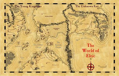
WIP: Isle of the Purple Towns
Well, I’m re-mapping Michael Moorcock’s, Young Kingdoms as part of my Elric of Melnibone campaign and I’m doing the overland maps in B&W to maintain that old school feel. This island is one of a couple of potential starting points which are getting done first. Regional, city and local maps will be in colour…so you will likely see “purple” towns😉

-
Using ProFantasy Software for A Commercial Board Game Project
I had similar questions which I emailed directly to Profantasy. The response was both quick and extremely helpful.
In my case I wanted clarification of how I could use jpg exports in virtual tabletops. The main map(s) were fine; despite being 'floorplans', they're clearly maps and not an issue. The issue I had was with GM only information. How could I show traps and such without breaking the EULA? Let's face it, the easiest thing to do for personal use is just import the png symbol into your VTT of choice and use it as a token or whatever. Clearly that is in breach of the EULA for commercial purposes as you're selling a symbol, a piece of PFs artwork.
In the end, PF was happy with my proposed solution (I sent them samples so they could see exactly what I intended and how it would work) and I just had to include an attribution to Profantasy, I don't recall the exact wording but it was very simple and absolutely no trouble.

-
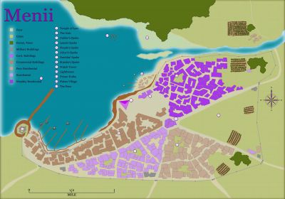
WIP: Kariss, Isle of the Purple Towns
Thanks @Wyvern. I was contemplating using the same technique for the cliff lines for the watchtowers and lighthouse but I think, despite it taking much longer, I'll do them by 'hand'... like I did for Mernii.
-
Why should I buy CC3+?
Well...nothing overly insightful here. I came to CC3+ from Ps. Learning both programs, not the art of good map making, took me about the same time to get to a similar level of proficiency with the software. However, I can make much better looking maps, in a wide variety of styles with CC3+ for far less effort, much quicker than I could even dream of in Ps.

-
One Page Dungeon with CC3?
I did as Sue suggests for my OPD entry (Ps for map, before I 'upgraded Macs) in 2017. I recreated the map in CC3+ see my gallery, personal album.
Trying to do the whole thing in CC3+ would be a challenge but the map itself should be fine. I would caution against anything too detailed as a lot of that may be lost re-sizing the map, depending on the amount of text of course; vector and simple bitmap styles, particularly the B&W ones, would be my recommendation.
-
Tang Shen - The Spider City
I really like the map.
My only critique is the seemingly random numbering of the named locations. I prefer them to be more sequential. For example #5 in this map I would've numbered as 4 and then continued counter-clockwise inside the city finishing at 14 which is currently #10. To me it just makes things easier to find. In a small map it's not so bad but on a larger one...

-
Scaling Bitmap Fills
Here's what I've got so far. It's getting late here, so I'll attack it again tomorrow.
-
A quick series of maps for Roll20
Hi Frosty,
For dungeon maps when exporting to a VTT as a Rectangular Section JPEG (or PNG if you prefer), use the distance tool to measure the width and height from the inside edge of the frame (if it has one) and divide by 5, e.g. a 200ft x 160ft map will give you 40 x 32 this is your inches at 5ft per square. In the options tab of the save as dialogue, set your resolution to 70 for Roll20 (or whatever the preferred resolution is for your VTT) and input the number of squares/inches. Make sure when you hit enter - NOT - to include the frame in your selection.
Make sure your page is at the correct dimensions and you should be good to go, your map and grid should align perfectly. If using in a VTT I never export with CC3+'s grid, prefering to use the VTT's.

-
Trying to salvage a very old map....
@Calibre Re your Text comments earlier:
I agree with your typographer instructor for designs featuring predominately text - they certainly benefit from complimentry sans and serif fonts with one being used for headings and the other body text and low level headings. As the old saying goes; you should the know the 'rules' before breaking them.
If you wish to use multiple fonts on a map go for it but I would recommend using one font per feature type, e.g. Font A for Mountain Ranges, Font B for Forests, Font C for place names etc. Tweaking the glow effects can provide a solid outline for text to make it stand out or you can do the opposite and increase the glow distance and reduce the opacity to provide a light background to the text to make it pop.


