


Monsen
Monsen
About
- Username
- Monsen
- Joined
- Visits
- 723
- Last Active
- Roles
- Administrator
- Points
- 9,029
- Birthday
- May 14, 1976
- Location
- Bergen, Norway
- Website
- https://atlas.monsen.cc
- Real Name
- Remy Monsen
- Rank
- Cartographer
- Badges
- 27
Latest Images


-
FAQ: Frequently Asked Questions and their solutions
Questions
- I know I have lots of fills (textures) installed, but they aren't available in my map.
- My drawing tools are missing their textures (or show incorrect textures)
- I've imported new fills into my map, but they don't show up in the drawing tools window.
- I can't select entities properly
- My symbols disappear when I scroll/zoom
- My symbols/tools draw on the wrong sheet
- Autosave prompts are annoying
- Exporting takes a very long time
- Some effects (like shadows or lights) stop short on my exported image
- I get a Source file not found error message when installing the latest update


-
Community Atlas - Sea Elf Outpost (off the coast of Menina Island)
Thanks Kevin. The map is now in the atlas. Welcome as a contributor, it is much appreciated.
That linked area do get a bit small though, very hard to see. Maybe someone wants to make an intermediate map showing the surrounding reef area in more detail.
(This will be the last map I add for a couple of weeks)


-
Community Atlas Project - Download information - Contributions Welcome
As I have just posted the competition for the 1000th atlas map, I will have to suspend regular submissions for a while. After all, since the competition is about the 1000th map, I don't want any side submission sneaking in and pushing us over outside the competition.
I may accept a few, since we are still 13 maps short, but no big map dumps until after September.
-
Community Atlas: Queen Mica's Scintillant Palace
Wyvern's new holiday location is now alive in the atlas. Thanks for contributing these interesting maps.


-
Wishlist for CC4
One of the main advantages with 64-bit is getting rid of the memory constraint. As a 32-bit program, CC3+ can only address up to 4GB of memory, but with 64-bit it would be able to use all the memory in you machine, no matter how beefy, for a long time to come.
There are other advantages as well, but for CC3+ that is the biggest advantage.


-
WIP: First BattleMap: Ice Caves
Note that lights ends at the FAR SIDE of objects blocking them, this means that the wall around the lighted area will always be lighted. Generally, this makes for much better visuals otherwise you wouldn't be able to see the walls at all which looks weird, but it results in an undesirable effects when your wall si the entire area outside the path, like typically in caves. The way to fix this is to use a set of thin walls on a dedicated light blocker sheet. I usually draw these slightly inside the cave walls, allowing for the light to illuminate the edge of the cave wall. Note that the lighting is also computed on a raster rendering of the map, which means it needs to deal with pixles. This makes very thin lines unsuitable, as light can shine through gaps, so make sure such blocker lines have a certain amount of thickness.
For the map border, just erase and redraw it. The technical map border is just four lines outlining the map on the MAP BORDER layer.


-
Last map of the Year
Love it. Nice example of a proper modern city with central heating.


-
Possible map for roll20 game
I find going with my own world so much more rewarding than those published worlds. It's more work on one side, but oh so much more flexibility on the other side, and the opportunities for a place the players can truly explore rather than read all about in a book.
Map looks quite fine to me. If anything, I think it might need some more settlements, but that can be a thing for detail maps. Since it had land et every edge, you can bet that the players will soon enough want to travel there and see what is beyond, so I hope you are prepared for that.
-
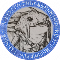
After importing bitmap fill styles, how do I use them?
When you add new fill styles, drawing tools won't be created automatically for them. This is partly because drawing tools are specialized tools for different purposes, not a one tool per fill type of deal, as you can see some tools are smooth polys, others are fractal polys, they have different kind of outlines based on their purpose, they are set to go on the appropriate sheet and so on.
When you import fill styles you can manually create your own drawing tools that include these, but more commonly they are accessed by clicking on the Fill Style indicator in the top right of the main CC3+ window, and go to the bitmap files tab. Here you can see all the fills in the map (with preview), and whatever you pick will be the current fill which will be used when you draw things with the basic tools found in the right hand toolbar. Of course, when you use the basic tools, you also have to remember to set the sheet and other properties manually too.
-
Invasion of Warlock
For abstract symbols like this, there aren't any correct scale to draw them at. So what I usually do is to place another symbol I imagine will be similarly sized down into the map (Such as the explosion symbol from your example above) at scale 1.0, then I use the distance tool to measure the sizes, and then use these measurements as a guide for my new symbol.
Just remember to always work at scale 1.0 when you are creating the symbols. If you place down the guide symbol at scale 0.1 and measures it and creates the new symbol based on that, the new symbol will be 10 times too small.


