


Monsen
Monsen
About
- Username
- Monsen
- Joined
- Visits
- 723
- Last Active
- Roles
- Administrator
- Points
- 9,029
- Birthday
- May 14, 1976
- Location
- Bergen, Norway
- Website
- https://atlas.monsen.cc
- Real Name
- Remy Monsen
- Rank
- Cartographer
- Badges
- 27
Latest Images


-
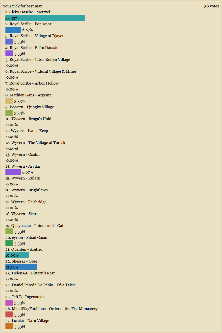
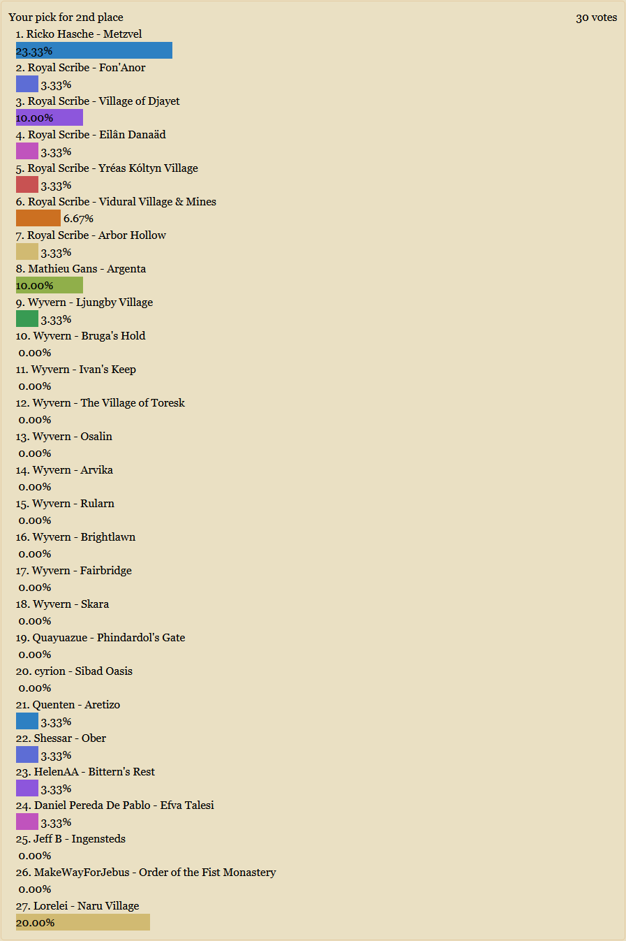
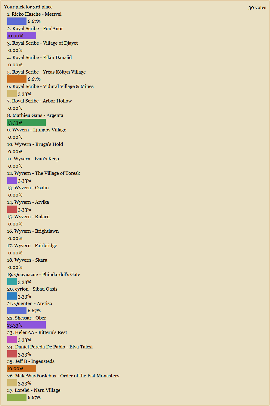
Community Atlas 1000th map Competition - Please Vote (Even if you didn't participate yourself)
The 1000th atlas map competition is now over, and below is the voting and gallery of the entries into this year's competition. Please vote for your favorite ones, even if you didn't participate in the contest yourself. We want as many votes as possible to ensure the fairest result.
The voting period will end on Sunday October 20th, 22:00:00 UTC.
Remember, these maps are fighting for the recognition of being the best maps in the competition, with ProFantasy store vouchers for the top 3.
I've shown all entries in the post below, but some maps at the end are excluded from the actual voting, these being mine, Sue's and Ralf's due to us either working for ProFantasy or arranging this contest. Also note that the rules stipulated one price per mapper, so should someone the same mapper have two maps in the top 3, they will only get the best prize they qualify for, the other prize will move downwards in the list to the next eligible contestant. This also applies to the prize for the randomly drawn 1000th atlas map which will also be announced at the end of the voting.
If you prefer to view the submissions in the image gallery viewer, this link leads to the first entry, and you can use the arrows in the top right to navigate back and forth.
Below, you will find three poll questions, to decide which map you prefer for first, second and third points. I'll give the maps points based on your votes (8 points for a first place vote, 5 points for a second place vote, and 3 points for a third place vote) and at the end of the voting period I will tally up the points and present the final list.
Some mappers have submitted more than one map to the competition. If you want to give them one of your votes, but do not prefer any one map of theirs above another, I recommend giving the vote to the first of their maps in the list. This allows them to collect most of their votes on one map instead of being randomly spread over them which hurts their chances since we are voting for best map, not best mapper.
For voting, please don't just consider how visually pleasing the map is, but also take into account the premise of the competition. Does it represent a conceivable fantasy village? Is it an interesting adventure location? Is the map good work by the mapper, or is the beauty just in the style they picked?
And to to all the contestants, please don't despair if your map gets very few or even no votes, it doesn't mean people dislike your map. But since we are only voting for the top 3 and not ranking every map, and due to the fact that these competitions don't get too many voters in total, most votes will tend to go to a small selection of the maps.


-
a prototype under ground home for a dragon and some questions
Did you also apply the color key effect to that sheet?
You can create cut-outs on as many sheets as you want, but there are a couple of things to check
For each sheet with a cut-out:
- There must be the color key effect on that sheet, and the color key effect must be the top effect in the list of effects for that sheet
- There must be a polygon in the cut-out color on that sheet, and that polygon must appear on top of the things you wish to cut
- And of course, the things to cut must also be on that sheet. Even if you set up the effect and poly correctly, it won't do any good if the entities to cut is on the wrong sheet. It only cuts things on the same sheet.
-
A gallery question
No, you can't add hyperlinks in the gallery.
While not exactly the same, you can add all related maps to the same gallery album. When you click a map in a gallery album to view it, you can use the arrows in the top right corner of the viewer to go between all the maps in that album.
-
A small carpenter store
To set that off I can simply rotate the Grid and the image in opposite directions and will technically not fit anymore
True, but designing things around a grid in the first place tends to have some artificial implementations, like all the corridors being exactly the same width, all rooms being a multiple of 5' (or whatever grid size is used) and so on. This often leads to features being oversized (Corridors in my home is not 5' foot wide for example, even allowing for wall widths). I enjoy the organic feelings of a building not designed to such artificial limits.
The way you did the angled corners for both the fence and the walls, and the nice angled placement of the big table and a lot of other stuff do go a long way to combat this look though.
But please don't let these comments distract from the map. It is a nice and well-made map, and for battlemap use, you often need to allow for some artificiality.
-
Community Atlas Project - Download information - Contributions Welcome
Thanks for joining in @Kertis Henderson
As Quenten said, just go ahead. I won't register the claim in the atlas right now, but there shouldn't be anyone else desiring that area presently.
One hint about that area though, even if it is a small area of Doriant, Doriant is a huge continent, so that area is pretty large. About 500 by 350 miles, or 175 000 square miles, almost the size of the entire country of France, or a bit larger than the entire US state of California. The lake is about the size of Lake Ontario. Keep that scale in mind when deciding which features will realistically show up on the map. Those red dots on the continent map would represent some of the biggest cities around, capitals and metropolises.

-
Struggling to select an area to work on.....
There is a blog article here:
Since you mention the hex grid, while it certainly is possible to transfer suing the same process, I recommend just dropping it and creating a new one. You'll normally want smaller hexes anyway for your detailed area map.
Here's also a video with Ralf explaining the process.
vthumb(EXQYu2ayFTc|Live Mapping: Regional Zoom)
-
The Lands of Strauvuvrorr
I was more thinking along the line of fading the lines out, making them more transparent.
But yea, I also like the smaller lines better.

-
an odd background
This bitmap isn't really intended to be used as a main background, rather it is meant to be used with drawing tools to draw patches of heath on top of your terrain background.
One limitation with CC3+ is that fills can't be categorized. So the background fill picker in the new map wizard will simply show all the bitmap fills available in the map, it has no idea which fills are suitable and which are not.
-
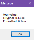
Macro square root calculation
I can't remember if there is a better way off the top of my head, but you can control the number formatting pretty well if you do it manually, like in my simplified and overly verbose example here:
MACRO TTT
GV a 1/7
GN b a*100
GN c a/100
GV d a-c
GN e d*100
GL out Your values
APND out
APND out Original:
APND out a
APND out
APND out Formatted:
APND out c
APND out .
APND out e
APND out m
MSGBOX Message;out;
ENDM

-
Community Atlas Project - Download information - Contributions Welcome
Sounds good. Have fun. Add cats.


