


Monsen
Monsen
About
- Username
- Monsen
- Joined
- Visits
- 723
- Last Active
- Roles
- Administrator
- Points
- 9,029
- Birthday
- May 14, 1976
- Location
- Bergen, Norway
- Website
- https://atlas.monsen.cc
- Real Name
- Remy Monsen
- Rank
- Cartographer
- Badges
- 27
Latest Images


-
CA style development - "Darklands City" (issues for September and December 2021)
Yes, that's the most likely explanation.
A alternative explanation is that you simply didn't notice there was more pages. Opening a thread shows you the latest unread message, which would have been Medio's on the bottom of page 2. If you didn't notice the page counter wasn't on the last page, you may simply not have realized there were further messages there.

-
City of Nyxotos for the Community Atlas
Tonnichiwa's city have now been added tot he atlas. Thanks for the contribution.
![[Deleted User]](https://secure.gravatar.com/avatar/c75d9a245b74d9c59be0999ea81ca541/?default=https%3A%2F%2Fvanillicon.com%2F92add7f8c954488718110edc4896ad39_200.png&rating=g&size=200)
-
WIP: Calibre vs Beleriand...
@Calibre wrote:
I was trying to find a way to scale all tree symbols in this map. Symbol manager informed me that, yes, I can. All current and future altered symbols would be at the new scale. Not So! heh. When placing the tree symbols individually, some were rescaled, some not, and some at scales I didn't set.
Changing the scale in symbol manager is done on a one for one symbol basis. So if you did it to a single tree symbol, then that particualr symbol would be rescaled and also placed at the new scale, but not "all trees". Symbol manager also only shows you symbols you've used in your map so far, so it is impossible to use it to use it to change scale of future symbols you haven't used yet.
Also remember that the scale you set in symbol manager will represent the default scale of the symbol, but a symbol will still be affected by the current symbol scale from the symbol parameters dialog.
Is there away to restore the symbols to original scale all at once?
No. You need to scale them one by one in symbol manager. And note there is no concept of original scale. Once you have scaled something, the actual entities are changed, it's not something that can just be turned off again. You need to scale them with the appropriate reverse operation (for example, if you scaled them to 0.5, you need to scale them by 2 to get them back to the original size.)
Since I rescaled them, why did Symbols in Area ignore the new scale? I checked each symbol in the manager and it showed the new scale, but with SIA, they populated at original scale.
Are you sure you used the same symbols? I did a quick test, and SiA obeyed the scale of the symbols according to the symbol manager. Note that SiA uses the default symbol scale for the map though, so while manually placed symbols are also affected by the scale from symbol parameters, SiA is not, it fetches the default value from the drawing presets dialog instead. Of course, there is also a scale option inside SiA, if that is set to anything but 100%, that will also change the scale the symbols are placed at.
-
Community Atlas-Elen Daelarion-The Mithlas Holes, 8
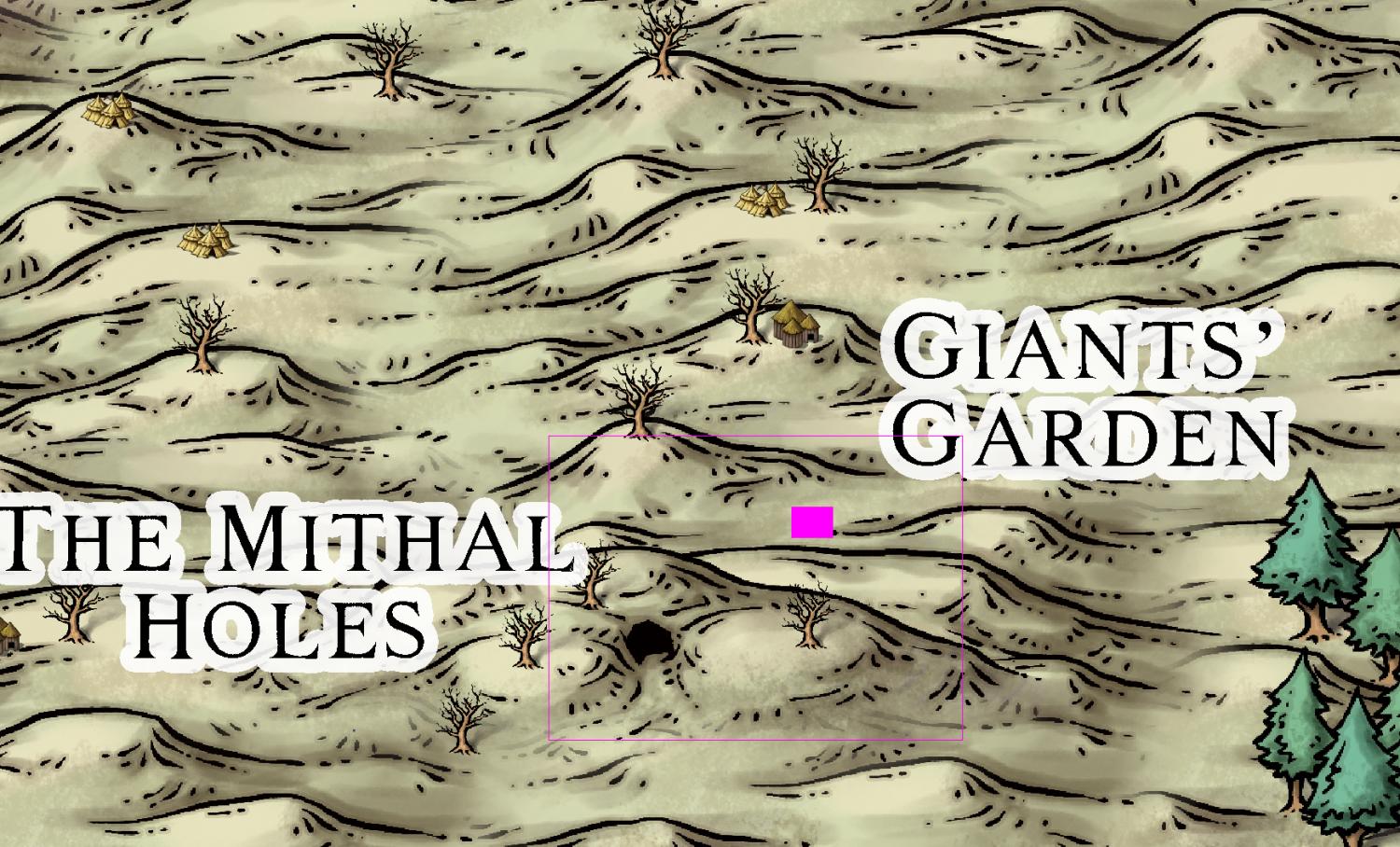
@JimP Looking at these now, and I am wondering a bit on the scale of the the_mithlas_holes_hillentrance.FCW map. The entire map is 3000 x 2200 feet. Converted to miles, that's 0.57 x 0.42 miles. That means that the region on the parent map (the_mithlas_holes_area.FCW) it describes is utterly minuscule, and wouldn't really fit both giant's garden and the mithas holes entrance on the same map. See the solid colored pink rectangle in the image below for the actual area covered here.
The map itself is fine as it is, so my suggestion is just to scale the entire map by a factor of 10, making it cover 30000 by 22000 feet instead (Suggested size shown by the hollow pink rectangle in the image), or whatever you find appropriate. Just remember to actually scale the entire map by the chosen amount, and not just edit the number on the scalebar.
Scalebar on the_mithlas_holes_entrance.FCW also reads "Scale in Miles". I am assuming this is feet?
-
WIP: Now, for something completely different...
Trace have an unfortunate aversion to smooth polys. You can usually get it to work as desired by turning them straight temporarily, trace, and then turn them smooth again.
As for going the wrong way around, it will do that until you have moved your mouse far enough from the starting point that you pass the selection point. Trace always go through the selection point, so if you haven't moved your mouse far enough yet to pass the selection point, it is forced to go the other way around to be able to go through it. I usually always make my selection point quite close to the starting point (but far enough away that I am 100% sure it is on the right side of it) to minimize this behavior.

-
Deleting posts
Through the cog in the top right corner of the post. Note that you can only delete a comment, not a topic. The latter is due to how the developers wrote the forum software, since deleting a topic would also mean deleting all the comments of the topics (which probably don't belong to the poster of the topic), so they simply did not allow users to delete topics (even if there are no comments yet)
-
Creating symbols and "Symbol Definition"
Symbols keep their layer when defined, and the entities should normally be put on the SYMBOL DEFINITION layer before you define them, this won't happen automatically. As for the Common sheet, that doesn't really matter that much, since sheet information is lost when defining the symbols, but having all entities on the same sheet is a good way of seeing that things look right, otherwise the actual entity order in the finished symbol may not be as you percive it since sheet ordering trumps entity ordering. Using Common is a good practice, because Common isn't a sheet at all, it is just all the entities that doesn't actually have a sheet, which is exactly the situation for a symbol definition.
For the catalog, yes. A good way to build a custom catalog wich includes existing symbols is to first make a catalog with your symbols, using save as catalog from the symbol manager. Then, open this new catalog up as a map (as opposed to in the symbol catalog window), and then open up the catalog with the symbols you want to insert in the symbol catalog window, clicking on each symbol once to import it into your own catalog. Then simply save it (using the normal save button this time, no need to to the symbol manager route every time).
-
WIP - Water's Edge Exercise Distraction
Well, I guess that too will serve to keep a map dry. Well, unless you try to use it as a flotation device that is....

-
WIP - Water's Edge Exercise Distraction
Oh, and to save you a click on the explode button, you can configure a symbol to automatically explode on placement, although this option is not compatible with the multi-sheet option for symbols.
-
Annual 174: Ancestry. Two maps - a Royal line, and an Evolutionary tree.
Mennidas' linage is now in the atlas. Thanks for the contribution Quenten.

