


Royal Scribe
Royal Scribe
About
- Username
- Royal Scribe
- Joined
- Visits
- 9,944
- Last Active
- Roles
- Member
- Points
- 3,476
- Birthday
- February 5, 1968
- Location
- San Francisco, California
- Website
- https://legacy.drivethrurpg.com/browse/pub/31814/Royal-Scribe-Imaginarium
- Real Name
- Kevin
- Rank
- Mapmaker
- Badges
- 16
Latest Images

Reactions
-
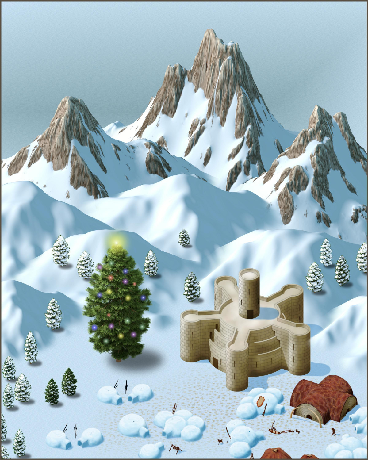
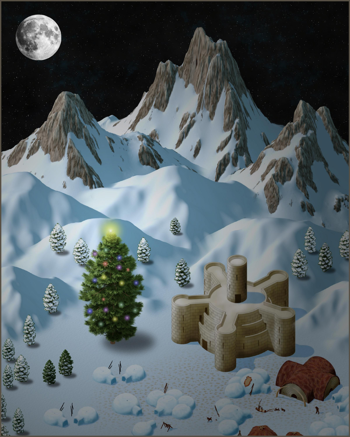
[WIP] The Toy-Maker's North Pole Workshop
Another holiday scene, this one a community of gnomes living near the North Pole working for a "jolly old elf" known as The Toy-Maker.
I have three versions: one daytime and two at night. One of the nighttime ones uses a galaxy background from one of the Cosmographer annuals (the bitmap file calls it "Hubble_Galaxy"), and the other uses a starfield background that comes with Cosmographer.
I may choose one of these to make into holiday cards. Does anyone have a favorite? Also, I put a tower on top of the castle to give it a little more, but does it look goofy there?
Daytime
Nighttime 1
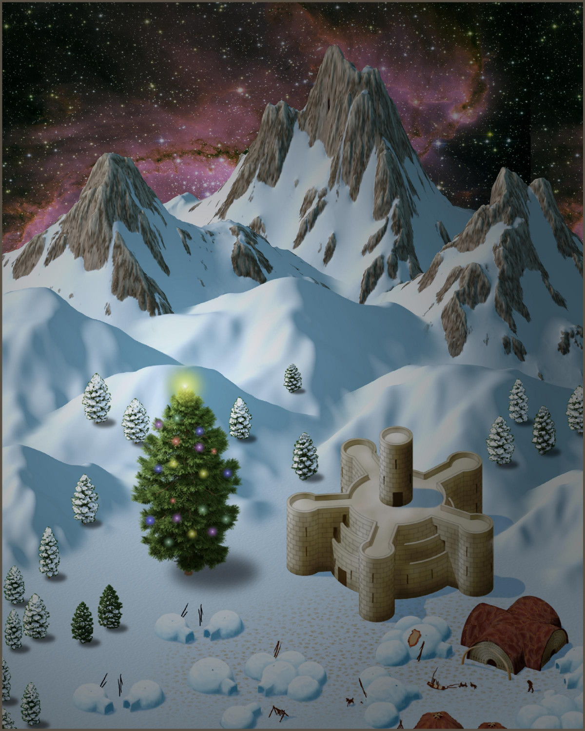
Nighttime 2


-
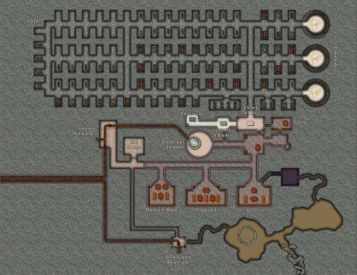
[WIP] Temple of Déine ap Gáeth
Temple of Déine ap Gáeth
In the human religion of the Áes Camáir, Déine ap Gáeth is the fourth of the five children of Camáir, the Goddess of Dawn and the mother of everything.
Déine ap Gáeth, the Snow Queen of the Áes Camáir, is the goddess of winter and storms. She lives on remote, snow-capped mountain peaks in a palace made of ice that is shrouded in perpetual fog. She is generally depicted with white hair and pale skin, dressed in garments that are silver and white with ice-blue accents. Though she is sometimes shown clad in all-white furs, she is more often shown wearing light clothing more appropriate for the summer for someone not immune to the cold as she is. She is seen as aloof and though certainly not evil, at least somewhat indifferent to the effects of harsh winters.
She is accompanied by Nathairsioc, a draconic spirit of wind and ice who is about the size of a large cat. She is also the mother of the Four Winds, whose father is believed to be a powerful elemental creature from the Plane of Air, perhaps the raw element of air or even The Féth itself, the mysterious fog that surrounds the palaces of the Áes Camáir. The Four Winds, who are considered to be demigods, serve as messengers of the gods and occasionally as liaisons between the gods and mortals. Though the Winds are not worshipped individually and have no priests dedicated to serving them, they do have shrines dedicated to placating and honoring them. It is said that there may be some warlocks for whom they serve as Celestial or Djinn patrons.
Although Déine is worshipped everywhere where the Áes Camáir’s followers live, her monasteries and the temples attached to them are generally located in snowy alpine and arctic environments, where her monks and priests are trained to survive in cold environments without special attire.
The Festival of Déine ap Gáeth, or Fayluh Déine, is a gift-giving holiday that begins on the Winter Solstice. In the Common Calendar, it also now marks the beginning of the new year.
At this temple, a bridge spans a great crevasse to connect the temple with its monastery. A portion of the temple has been carved into an icy bluff. Years ago, a family of yeti accidentally broke through to a portion of the temple. The priests and monks were able to drive back the yeti, and have subsequently sealed off that portion of the temple.
1. Temple of Déine ap Gáeth: The temple for worshipping Déine ap Gáeth also includes a chapel for the worship of other Áes Camáir gods. Visitors typically worship here instead of the below-ice chapels. It also includes office space for the priests as well as living quarters for the most senior priests. The northern wing is buried in the icy cliffs, with a ceiling of ice about 20 feet above the roof of the temple, allowing for roof access beneath the ice. Two doors can be found in this wing. The northwest door provides access to a passage to a bridge, beyond which are tunnels extended for miles to a settlement of kobolds who some believe serve an old white dragon. The northeast door provides access to the subterranean portions of the temple. Another door on the southeast wing provides access to a road that winds around the rift. The primary entrance, however, is on an upper level reached from a bridge that spans across the crevasse to connect the temple with the monastery.
2. Monastery of Déine ap Gáeth: Here, monks and acolytes live and train for service to Déine ap Gáeth. From an upper level, a bridge extends across the crevasse to connect with the Temple.
3. The Great Crevasse: This massive rift in the ice and rock extends to unknown depths, and many have lost their lives falling in. Some claim that the rift provides access to the paraelemental plane of Ice, located on the border between the planes of Air and Water. Others claim that Déine’s own palace in the heavens can be accessed through the rift.
4. Reception Room: A gathering area for the below-ice temple. Though most of the below-ice temple has icy floors, this room has flagstone flooring.
5. Ice Chapel of Déine ap Gáeth: Religious services here are primarily for the priests and monks who live at the temple and monastery, as visitors generally worship in the anove-ground temple. An altar appears on a dais carved from ice, flanked by fonts of holy water on either side of the dais.
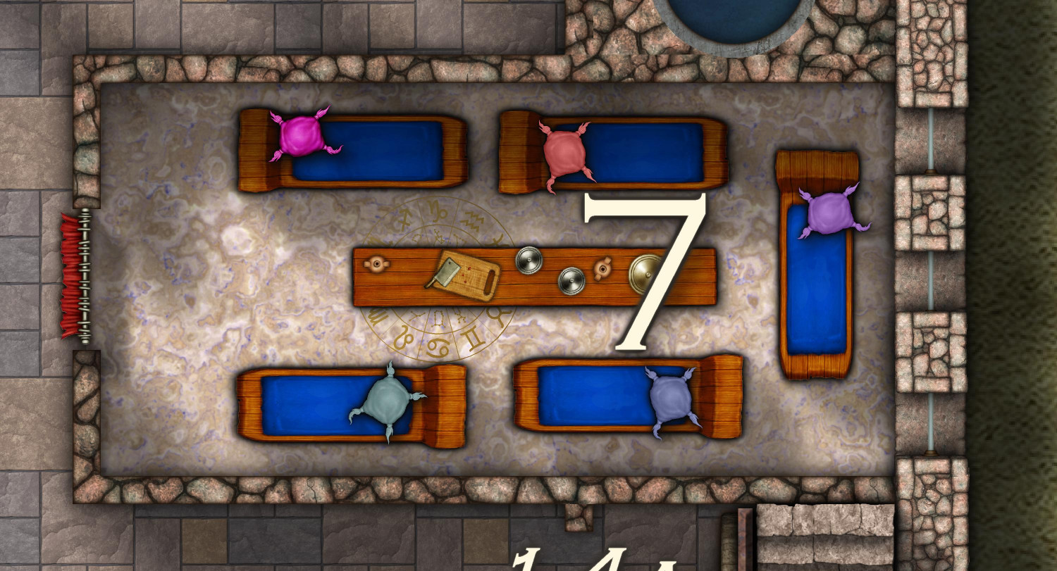
6. Hot Pool: Half of this oval-shaped room is used by a steaming pool as hot as any bath. The water is heated in pipes that extend from the Lava Room (#10). The floor is a white marble.
7. Ice Plunge: Once they have become warm in the hot bath or the saunas, some monks and priests like to plunge into a cold bath in this room, before returning to the saunas or baths to warm up again. The floor is blue tiles.
8. Steam Sauna: Water is poured over rocks heated by a brazier to provide for a warm, steamy environment.
9. Dry Sauna: No steam in this sauna, just a dry heat.
10. Lava Room: A tiny crevasse reveals a pit of lava that is used to heat the hot pool and saunas.
11. Office of the High Priestess: The high priest or (currently) priestess has an office here as well as in the main temple. This office is primarily used for changing into vestments before religious ceremonies.
12. Monks’ Rooms: Monks and acolytes who have completed their education typically spend a month living in these icy rooms before taking their final vows.
13. Chapel of the Four Winds: The Four Winds are sons of Déine ap Gáeth, demigods who serve as messengers of the gods. This main room has branches along the cardinal compass points to smaller shrines for each Wind.
14. Shrine of Anair ap Gáeth, the East Wind: Anair ap Gáeth, the East Wind, is seen as a bringer of warm rains. He is associated with the summer.
15. Shrine of Faitse ap Gáeth, the South Wind: Faitse ap Gáeth, the South Wind, is associated with the desiccating, hot wind of late summer and autumn.
16. Shrine of Íarus ap Gáeth, the West Wind: Íarus ap Gáeth, the West Wind, is the most gentle and favorable of the winds. He is associated with flowers, springtime, and procreation. In myths, he is presented as the tender breeze,
17. Shrine of Túaiscert ap Gáeth, the North Wind: Túaiscert ap Gáeth is the cold wind from the north. He is associated with storms and winter. He is depicted as being very strong, with a violent temper to match.
18. Fire Trap: Two locked stone doors block access to this room, once a storage room before the yeti broke through to this part of the temple. The priests have also added a Glyph of Fire here to keep the yeti at bay.
19. Blocked Chamber: In this chamber, the priests have used their divine powers to bring down an avalanche of icy rocks to block access to the yeti family’s home.
20. Yeti Lair: A family of yeti are believed to still dwell in these icy caves.
21. Yeti Exit: A passageway extends for nearly a mile below the ice before providing an exit. This allows the yeti to come and go while avoiding the priests who wield fire to keep them at bay.
22. Passageways to the Ice Kobolds: These passageways extend for many miles before reaching a settlement of kobolds who are said to worship or serve an old white dragon. The priests of Déine ap Gáeth have reached a truce with the kobolds, and occasionally trade goods and services with them.

-
WIP: Novarenga MKII
I am really liking this Parchment style for large-scale maps. I don't think it would suit my campaign world overall, but I can see my adventurers finding an ancient map in this style in some crumbling ruins, or being given one in this style when they consult with a sage or wizard for advice.


-
Shout Out to Ralf
I met Anne McCaffrey some years ago and she urged those in attendance to compile and keep a list of names which we could draw upon whenever we needed one. That practice has stuck with me all these years later, and I have lists of thousands of names I can use.
That's what I do, too. Unusual last names are good fodder for fantasy realm names of people or geographic places, though I sometimes tweak the spelling. I keep a notepad list on my phone that jot down names as I encounter them. Every so often, I paste the list into Excel where I can make notations when I use a name.

-
I'm hungry for your lore!
Thank you for the tip -- I will check out Fandom.com. I actually started my own wiki about my world of Adnati on my WordPress-powered website. I use a plugin called Yadawiki for the wiki functionality. The Religion section is the most developed, followed by Geoscience. (History so far covers ancient history but not so much "modern" history.) I have tons more plotted out in MS Word docs that have not yet made it onto the wiki, much of which would have to be kept private until players learn those elements of the world.
Now that I am finally starting to learn CC3+ and FT+ (after owning the software for about six years but being too intimidated to learn it), I can finally start doing some mapping. (I decided about six months ago to start watching the tutorials and surprise, surprise, learned so much more than I did on my own with the PDF manuals.)
I don't actually have any players at the moment. Just having fun worldbuilding. But I have a fully fleshed out concept of how the players will meet, the circumstances that get them into a group and kick-off the story, and the major elements (and end goal) of their campaign arc.
-
Compass Roses
They are absolutely stunning! These will be a great to have available for map styles that don't come with cartouches (and as a supplement for others that do).
As a jog for inspiration, if you're open to ideas: sinister/evil (evil sorcerer, lich king/vampire/undead, etc.), fairy tale, swashbuckler/pirates, maybe demihuman-inspired ones (elven, dwarven, halfling, orc, draconic)? Maybe seasonal -- your top one is great for spring and summer vibes, but it would be cool to have autumn and winter options.

-
Is there a way to add windows and other stuff to the walls from SS6 Isometric Cities?
There are a few isometric/perspective symbol sets that might help if you have the right add-ons or annuals.
CA149 Beaumaris Castle has both top-down and isometric symbols, including windows. You'll find the isometric symbols under:
C:\ProgramData\Profantasy\CC3Plus\Symbols\Perspectives\Castles\Beaumaris.
And if you have Perspectives, you may find more under the Bitmap A style:
C:\ProgramData\Profantasy\CC3Plus\Symbols\Perspectives\Bitmap A

-
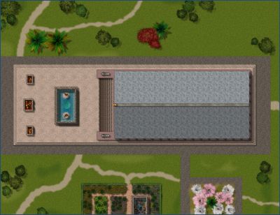
[WIP] Villa Citri (Roman-style villa)
Still have to add windows and doors, and furniture. Wish we had some Roman couch symbols!
Figured out how to do Roman couches without resorting to symbols that couldn't be used in the Atlas. DD3 has an armless cushioned chair, so I just stretched it x3 on one axis. I know some Roman couches have a partial back on one side, and others have the armrest (or backrest?) on both sides, but unless someone can find a chair with two arms but no back, this will do. Does anyone know how they would have been oriented? I'm thinking that the riser side in this configuration would all be on the left side so that guests could lean back while facing their host on the coach that's along the eastern wall.
-
Can't seem to draw backgrounds
Here’s a tutorial video focused on Trace. I haven’t had a chance to watch it yet myself. It’s older but if it’s just focused on the Trace command, hopefully it won’t be out of date.
-
[WIP] 1000th Map Competition: Elkton, Alarius North Central
I have been looking forward to seeing what you do since you first claimed Elkton.
Also: DD4 things! Squeeee!


