


Wyvern
Wyvern
About
- Username
- Wyvern
- Joined
- Visits
- 3,240
- Last Active
- Roles
- Member
- Points
- 5,521
- Rank
- Cartographer
- Badges
- 24
Latest Images


-
Hexcrawling starter maps
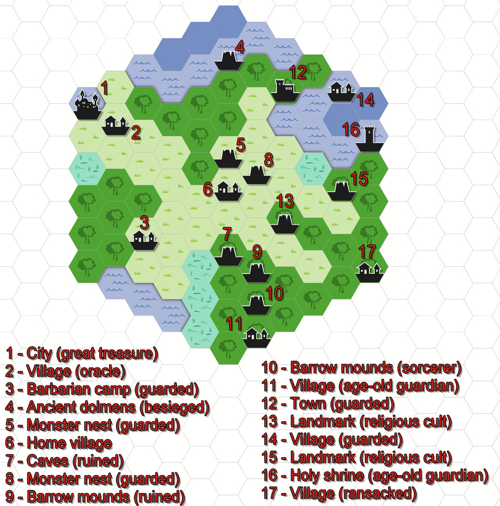
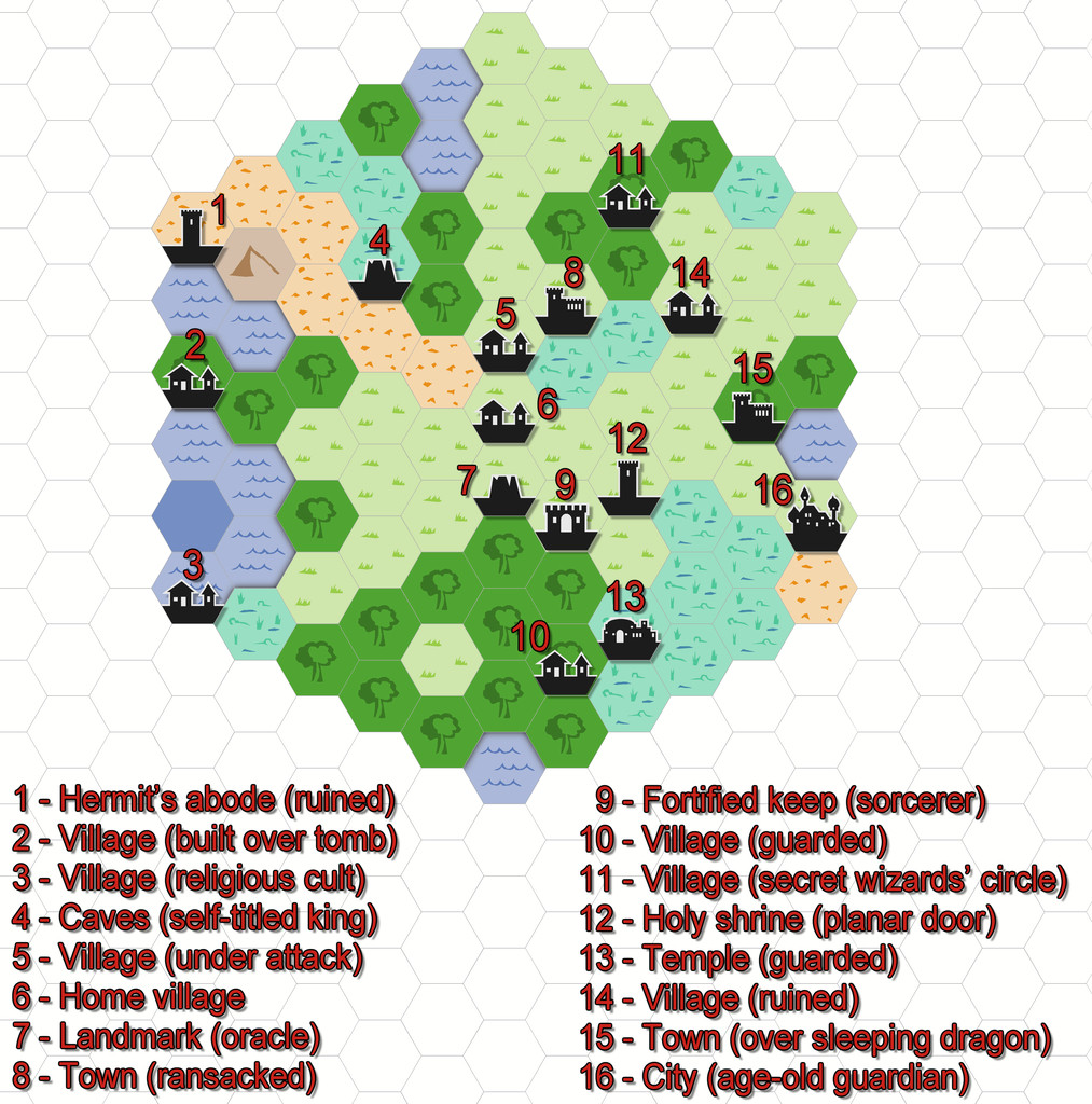
Just to make sure I'm not leaving anyone behind here, some brief explanation. From the early days of RPGs, those running the games have been encouraged to design areas for the players to explore, frequently using random generation systems to do so. "Hexcrawling" is the overland version of this, where each hex represents a fixed distance (if sometimes a little vaguely defined, given a hexagon is not the same size from its centre all around), commonly 5 or 6 miles, though larger or smaller sizes than this are not infrequent. What are now called "Old School Rules" (OSR) RPG systems often make use of this technique, and these have seen a particular upsurge in popularity this year, following ongoing problems from the current owners of "Dungeons & Dragons".
One of the unexpectedly phenomenal successes of recent times in the OSR line has been a new RPG called "ShadowDark", which presents a very streamlined update on the OSR theme, that incorporates improvements from modern RPGs more generally. I've been very taken with the whole ShadowDark RPG conception, particularly as the Core Rules include everything needed to play the game, such as a random generation system for hexcrawls.
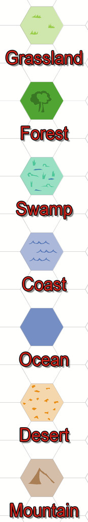
Last weekend, I did a couple of small test areas, to see how the system worked (hexes here are 6 miles in size), and although the system which will appear in the printed Core Rules has been tweaked a little since then, I prepared the maps in CC3+ through the week, to see how they'd look, using the 2010 Overland Hex style. These are the basic maps as generated by the random system rolls, with a list of their contents, and a separate key:


-
[WIP] World map, feedback?
This is a delightful-looking map - though I do especially like this style, so may be a bit biased!
A scale would be good, as the symbol sizes make it look like a little group of small islands right now, not a world map.
Maybe adjust the overall map size so the northernmost peninsula and tree symbol aren't vanishing off the top border edge of the map. It also looks as though the one snowy mountain symbol on this same northerly landmass is partly sitting over a couple of the grassy mountains that should be in front of it.
As Julian mentioned, some further ocean colouring would be helpful, and perhaps seeing if those two large green atolls in the northeast are on the same Sheet as the general landmasses, as they don't seem to have the same outer glow effect to them, which would hint at shallower seas closer to their shores, and perhaps also in their central lagoons (assuming that would be appropriate for what you have in mind here, of course).
-
Live Mapping: Black and White Cities
Yep, had guessed something must be wrong. Best wishes to Ralf for a speedy recovery!
-
Expansion to Ellis Prybylski Watercolor Style
Yes please to the Elf, Dwarf, Halfling and Orc structures, plus ruins, ships, icy elements, a volcano-mountain, variant settlement features (including for different cultures)! And after those, also perhaps:
- Magical site markers
- Battlefield marker, and a more general flag-style marker, to highlight important sites that don't fit to specific structure types.
- Oasis symbols for the deserts.
- Two more bridges at different angles to the current one - one running straight down the page, the other angled down from top left to lower right.
- I really like the Henge and Tomb hill markers, as they look good on any terrain. Another such marker with a cave mouth would be very useful.
- Some Mountain Peak symbols without the snowy tops (so grey mountains, just no white caps).
- Seeing the animal and creature comments, just the actual creature without any associated terrain would be better, as usable anywhere. Snag is, going down this route is liable to lead to requests for a lot more "resources" style markers - domesticated creatures and crops, minerals, etc.
- Some jungle-style trees, perhaps including mangroves, as well as the fruit trees Monsen mentioned.
I'll probably think of others later, but these are what're coming to mind right away. It's a wonderful style, and it would be excellent to see it expanded as far as possible in future, I think.
And thank you very much for creating it!


-
Mapping old computer roleplaying games
So are you planning on completing it now @Maidhc O Casain ? I do find something very appealing about the clean-cut lines of these older vector styles, personally.
