Royal Scribe
Royal Scribe
About
- Username
- Royal Scribe
- Joined
- Visits
- 9,528
- Last Active
- Roles
- Member
- Points
- 3,353
- Birthday
- February 5, 1968
- Location
- San Francisco, California
- Website
- https://legacy.drivethrurpg.com/browse/pub/31814/Royal-Scribe-Imaginarium
- Real Name
- Kevin
- Rank
- Mapmaker
- Badges
- 16
Latest Images


Reactions
-
[WIP] Temple of Fah (May Annual: Stairs and Steps)
Made some tweaks, particularly to the desert in the northwest corner. I added a TERRAIN SYMBOLS sheet of cracked seaflats. Over that, I did a second TERRAIN SYMBOLS 2 sheet for the sands symbol. And then finally, a third TERRAIN SYMBOLS 3 sheet for scattered dunes.
Also addressed the dimples in the temple by adding a layer of the gold foil for each level of the ziggurat. I probably won't add more color key "etchings in gold," but I had to add something, and now I'm all set if I do want more.

And recommendations?


-
Egg Hunt!
Years ago, when I was first developing the pantheon for the halflings of my world, I accidentally recreated the Easter Bunny.
I had in mind that idea that the head of the pantheon was a grandmotherly figure. I pictured her baking pies and sitting in a rocking chair on her front porch dispensing common-sense wisdom. I had a mental image of her as an anthropomorphized rabbit, like Peter Cottontail's grandmother or a Richard Scarry illustration. But when I had the thought that maybe the living creatures of the world came from eggs that she laid, I realized that I had recreated the Easter Bunny. I decided to lean into that.
Here's my description for Mother Ailish:
The de facto head of the Halfling pantheon is a four-foot tall anthropomorphized rabbit named Mother Ailish. She is depicted as a grandmotherly figure dressed in an apron, bifocal spectacles, and a bonnet or straw hat. When she isn’t shown knitting on her front stoop while dispensing common-sense wisdom, she’s generally shown baking in the kitchen. In her ovens she bakes any manner of delightful confections, particularly savory and sweet pies, and for this reason halflings celebrate natal days (and pretty much every occasion) with pies in her honor. It is said that she baked, piece by piece, all the non-living things of the world in her ovens and then fashioned them together. Every living this in the world is said to be descended from an original that she gave birth to – not in a live birth but laid in bright, multi-colored eggs that her many children and grandchildren (all also depicted as anthropomorphized rabbits) then hid about the world until they were ready to hatch and populate the world with life. For this reason, the halflings have a spring celebration in which they paint eggs made of paper, baked clay, wood, leather, or the like, inside which is hidden toys and candy, which are then exchanged with friends and family and sometimes hidden for strangers to find. The holiday always falls on the first Estaradÿn that falls on or after the first full Caerudraal moon after (but not on) the Spring Equinox.
(Caerudraal is the smallest of my world's three moons. It takes 77 days to orbit the world, and weeks are 10 days, so the holiday is celebrated anywhere from the day after the vernal equinox to 87 days after.)
Anyway, when I created some rainbow images for St. Patrick's Day, I thought maybe I should do an
EasterMother Ailish Egg Hunt for Easter.I used the Mike Schley Dungeon City style to create a halfling's home and garden. At first I tried to create varicolor decorations for eggs, but they're so small here that you couldn't see the decorations anyway. I tried to just create solid-colored eggs using the three-point circle drawing tool, but wasn't thrilled with the shape -- and the beveling effects didn't show up once the eggs were shrunk. I ended up just using Mike Schley's varicolor dragon eggs.
Anyway, here's my little halfling home and egg hunt:
Garden without Eggs
The home faces a rural lane, with the garden accessed through the home's back door. The garden has a gate that provides access to a side street. Everything comes from Mike Schley's city or dungeon assets except the hedges, which are Sue's connecting hedges -- and then I used her end/corner pieces instead of Mike's for the stand-alone hedges. And I think the flowers are miniaturized shrubs from DD3.
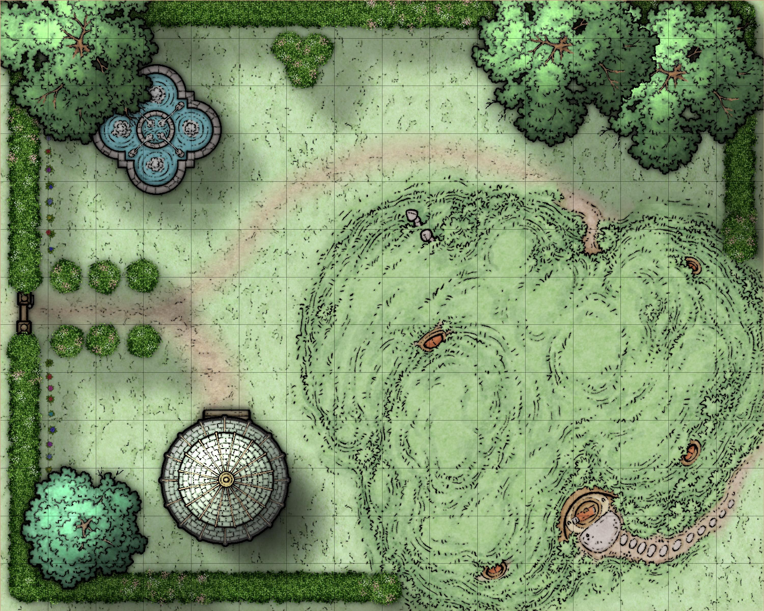
Garden with Hidden Eggs
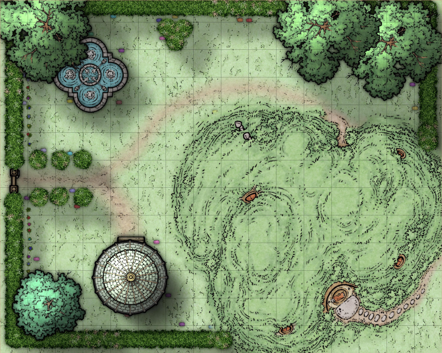
Under the Trees and Gazebo Canopy
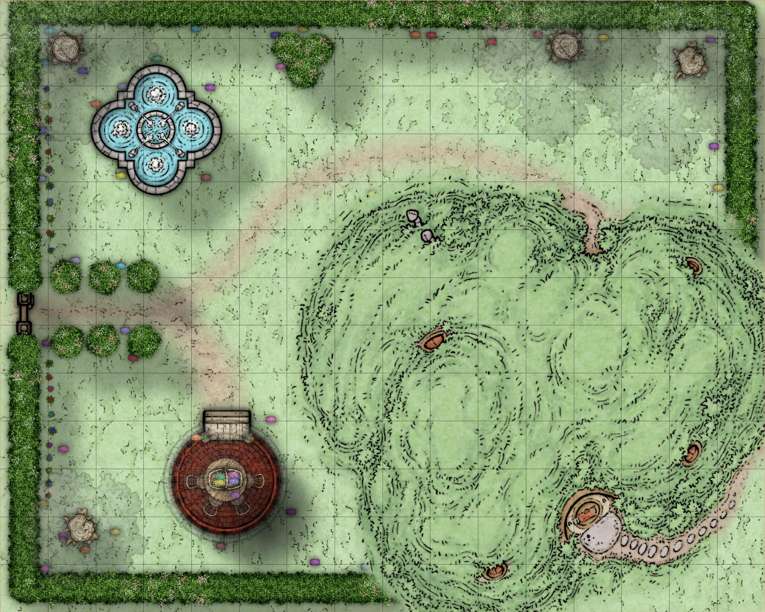
Mappy Easter -- er, Mappy Mother Ailish Day!


-
[WIP] Community Atlas: Kumarikandam - SE Tiantang Region
Here is the second of three monasteries I am mapping with Ricko. The description, written by Ricko, follows below.
The Sacred Path of Hei Shan Si
Toggle: CLOUDS layer to reveal/hide clouds
Toggle: VEGETATION - TREE CANOPY layer to reveal/hide the treetops
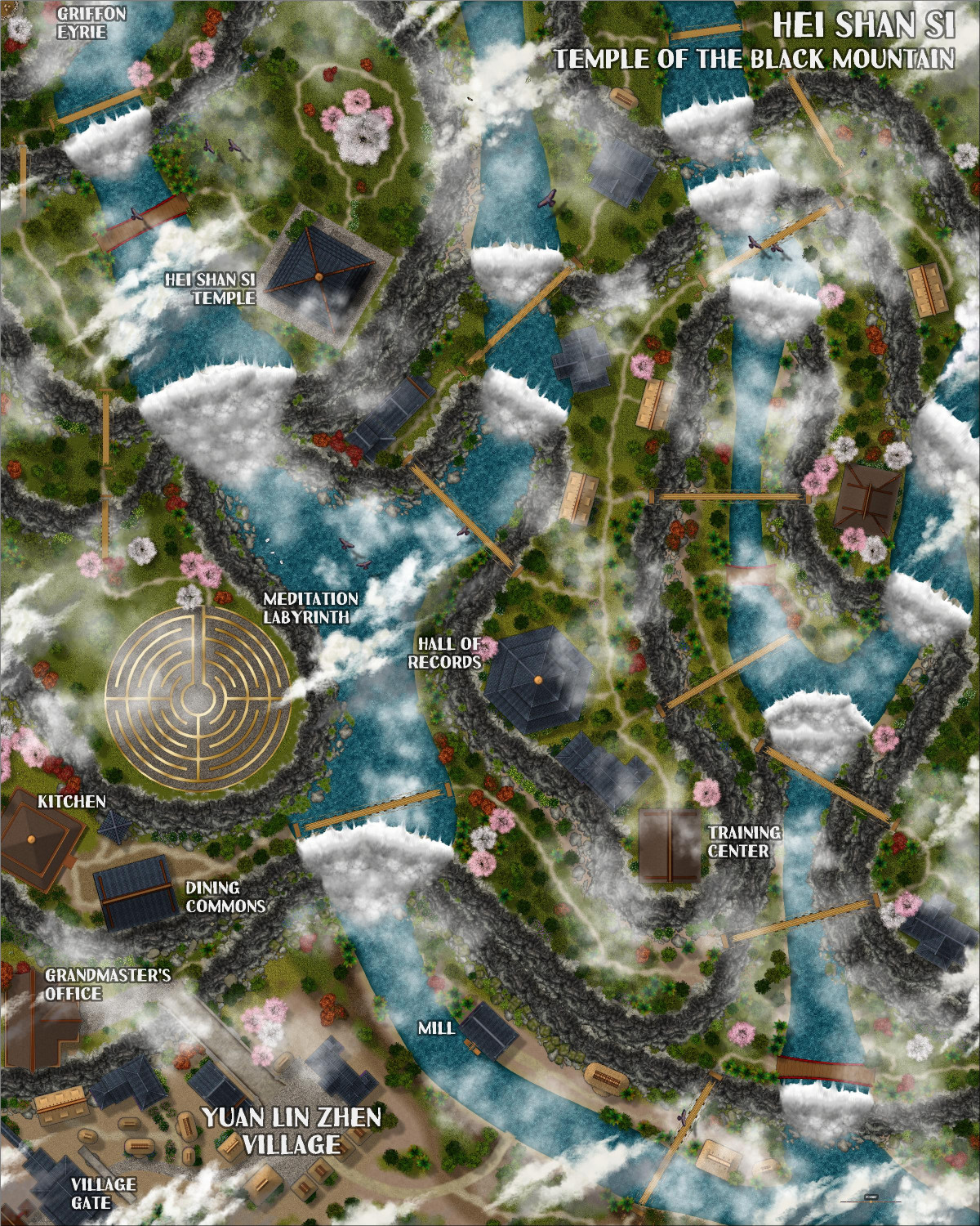
The Sacred Path of Hei Shan Si
In the heart of the Black Mountains and surrounded by the Ancient Forest, amidst peaks that touch the sky, stands the Hei Shan Si Monastery (Temple of the Black Mountain), a sanctuary of spiritual peace in contrast to the chaos of the surrounding region. Founded by an anonymous sage, the temple is said to have been built with the help of divine forces, its black walls harmonizing with the eternal shadows of the mountains.
The Challenging Path
The road to Hei Shan Si is a test in itself. It begins in the fertile valleys, and ends at the final stop in the village of Yuan Lin Zhen, passing through the living heart of the forest, steep cliffs and narrow trails that wind dangerously through the mountains. Incessant rain, dense fog and biting winds are constant companions of travelers. Worn rope bridges span unfathomable chasms, and legends tell of guardian spirits who punish those who disrespect them.
Beauty in the Wild
The temple sits on a plateau surrounded by stunning, untamed nature. Crystal-clear waterfalls feed rivers below, and flower gardens spring up naturally among the rocks. Rare birds soar overhead, their bright colors contrasting with the granite gray of the mountains. At dawn, the monastery seems to float amidst golden clouds, a sight that inspires reverence and humility.
Life at the Monastery
The monks and nuns who inhabit Hei Shan Si are few but dedicated. They live austere lives, cultivating the land and eating simple meals. They spend their days studying ancient spiritual texts, meditating on the edge of cliffs, and practicing rituals that are believed to purify the spirit and bring them closer to enlightenment.
Spiritual Ascension
Hei Shan Si is known for its unique teachings that combine philosophy, meditation, and the pursuit of balance with nature. The monks believe that the body and mind must be challenged in order to achieve enlightenment. In addition to their spiritual practices, they undertake rigorous physical exercises, such as climbing cliffs or meditating beneath icy waterfalls.
This place is not only a spiritual refuge, but a symbol of resilience and harmony in a land of turmoil. For the few who can overcome the hardships of the path and the shadows of their own hearts, the temple offers the promise of unparalleled peace and a glimpse of what it means to truly transcend the material world.


-
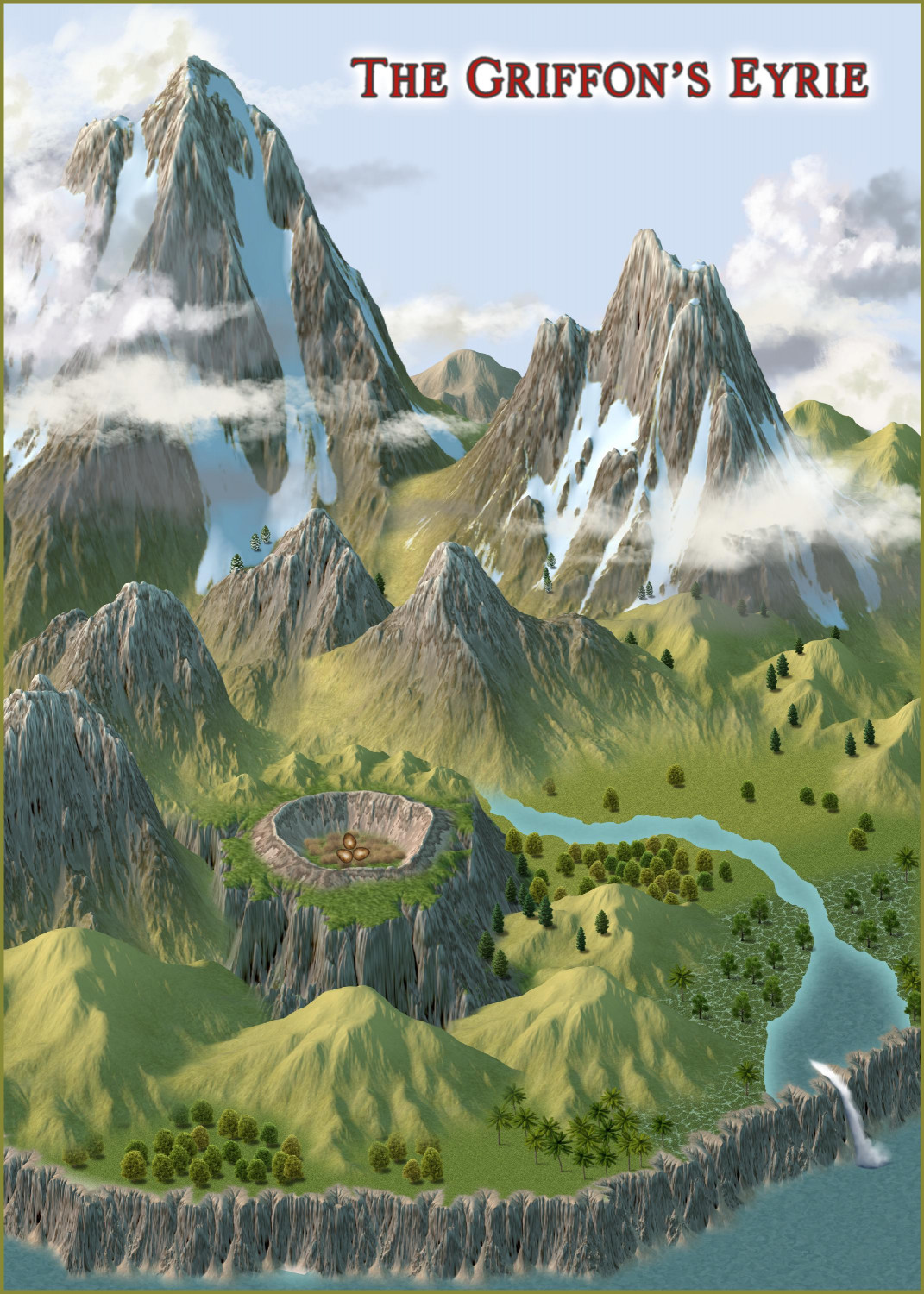
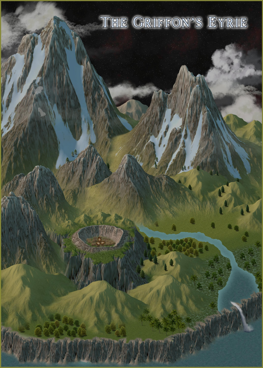
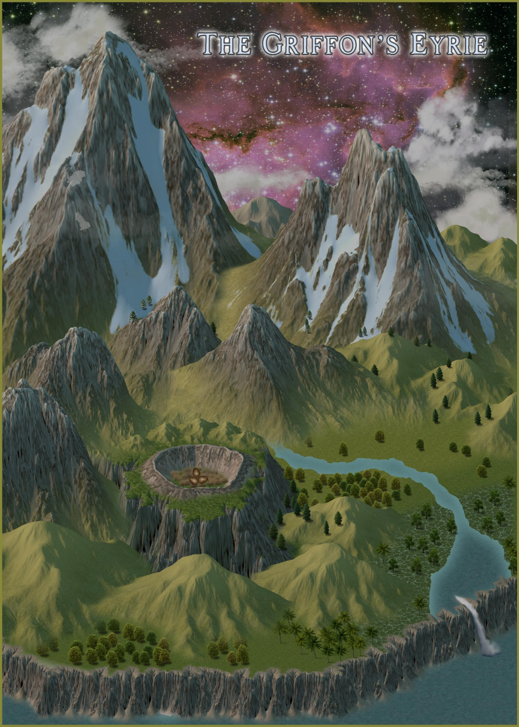
[WIP] The Griffon's Eyrie Redux: Spectrum Overland
Last month, I mapped a Griffon's Eyrie using Darkland Overland. I was looking for a little distraction today and decided to revisit it using the Spectrum Overland style.
Still a work in progress -- I want to add more trees, and I haven't had a chance to look at it closely enough to see if there are weird sorting issues or things I need to cover up with trees. But anyway, here it is. Everything comes from Spectrum Overland (even the nesting material) except the eggs are from Creepy Crypts.
Then I decided to see what a nighttime version would look like. This brings in a Starfield bitmap from Cosmographer.
And for something a little more galactic, here's the Hubble bitmap fill from Cosmographer.
-
[WIP] Villa Citri (Roman-style villa)
In my map of Tyr Alomere Township, you'll see a Roman-style villa on the left side of the map. Although I had planned to work on a major city next, I couldn't resist diving into mapping the villa. I was going to hold off on posting anything until I had finished at least one floor of the interior, but I just couldn't wait.
I knew when I placed the villa in the town that when it came time to mapping the villa, I would do so with the Marine Dungeons annual. The structure fills in that annual seem so Roman to me.
So here's the outside, and then we'll zoom in a bit.
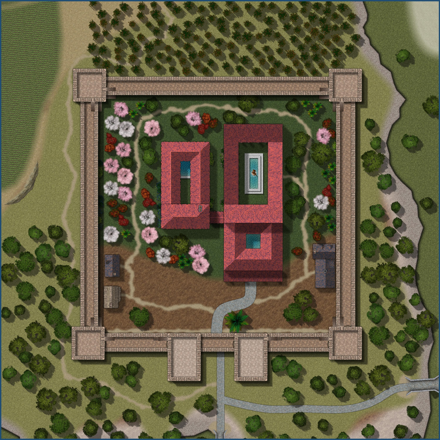
At first glance, it looks very similar to what you see on the town map. Since Marine Dungeon's vegetation symbols are primarily stuff you'd see in the water, like kelp and coral (it is a marine dungeon, after all), I continued to use the trees from Forest Trail and Japanese Temple, and other terrain fills from Darklands City. But there are some important changes.
First, the town had bluffs that used Creepy Crypts (because the wizard's tower that I built the town around used Creepy Crypts to make it easier to do the basement areas). When I brought in the villa to my Marine Dungeons map, I wanted replace as many fills as I could with Marine Dungeons ones. So the cliff walls use Marine Dungeon's pebbles fill, and the rocky covering was replaced with a Marine Dungeons rock. Works really well with the special effects that Sue developed for Creepy Crypts!
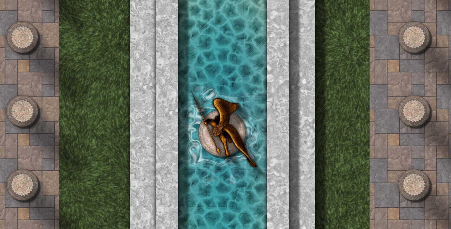
The building structures continue to use the tile fill from Darklands City, and continue to use the RGB Matrix to redden them in a way that seems more Roman to me. But the water was redone using Marine Dungeon's water techniques, though I had to make some tweaks. And the marble around the fountain and pools also comes from Marine Dungeons, though I tweaked the effects to make them more of a grayish-white.
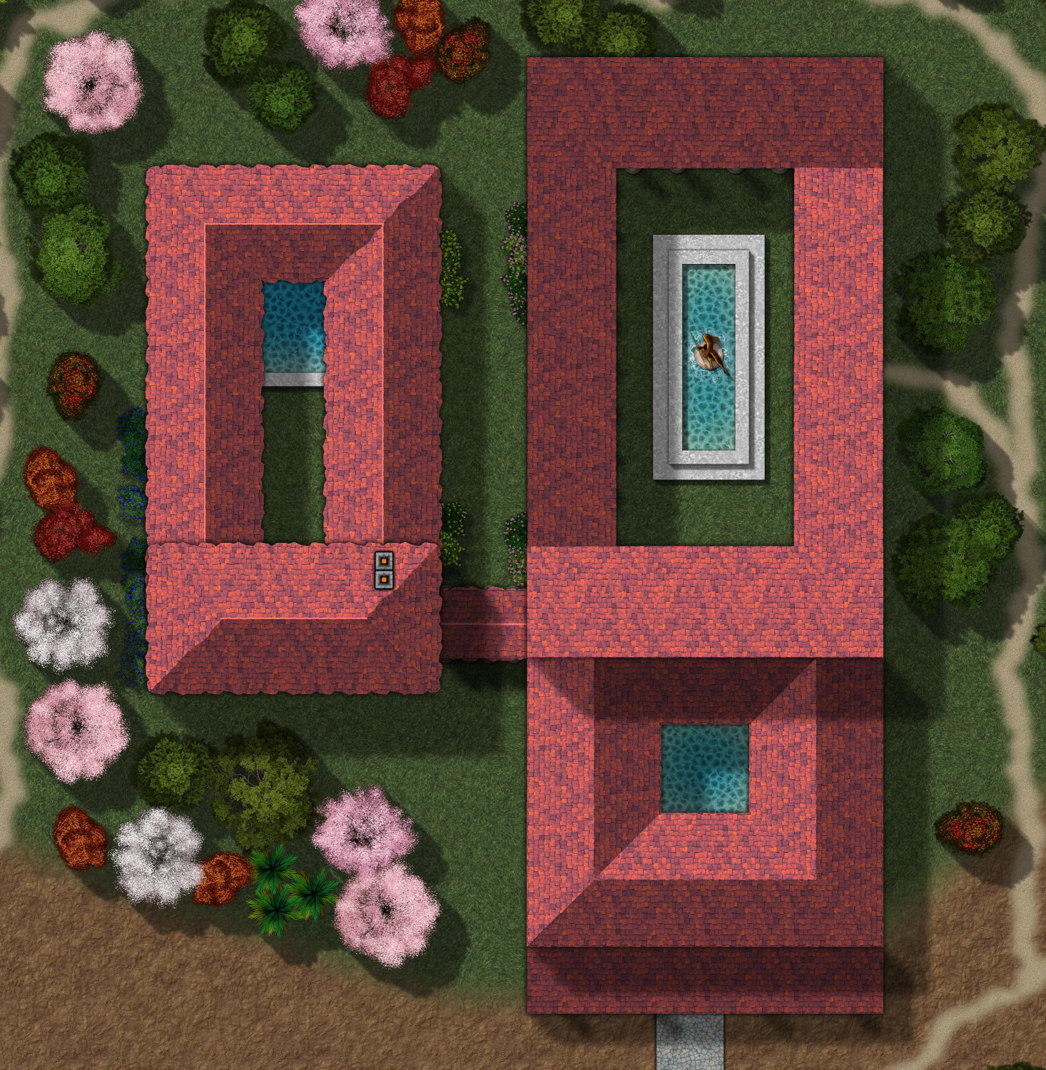
(The building on the left side is the baths -- many of the fancier Roman estates had their own baths.)
Also, you might have noticed shadows from columns around the courtyard. If I take the roof off, you'll see that I replaced the CC3 columns with the beautiful ones from Marine Dungeons.
And now for the defensive walls surrounding the villa. They had been designed in the town using the beautiful fills from the Beaumaris Castle annual, also used with the wizard's tower, but I replaced them here with the beautiful wall symbols from Marine Dungeons. I love how nicely the window symbols work as crenellations when plopped directly on the walls. I also used the arches from Sinister Sewers to show entrances to the top of the walls from the towers.
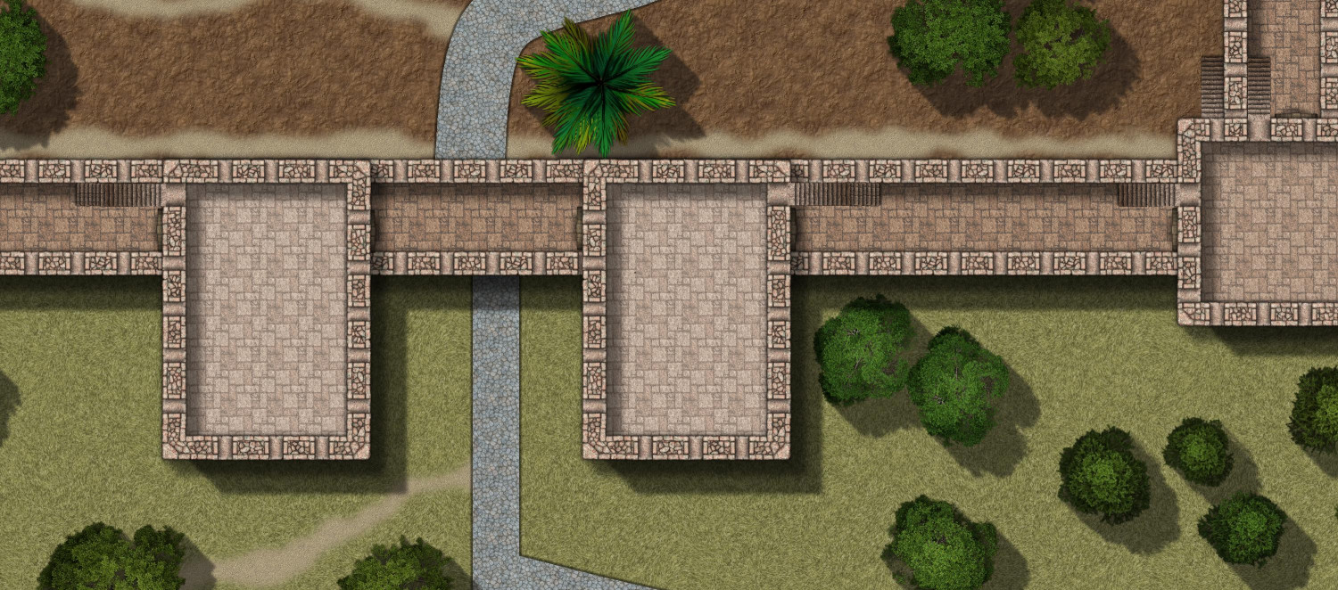
I know the paved road going to the gate is a bit off-center, but I decided to keep it consistent with the parent map.
Interiors coming soon!


-
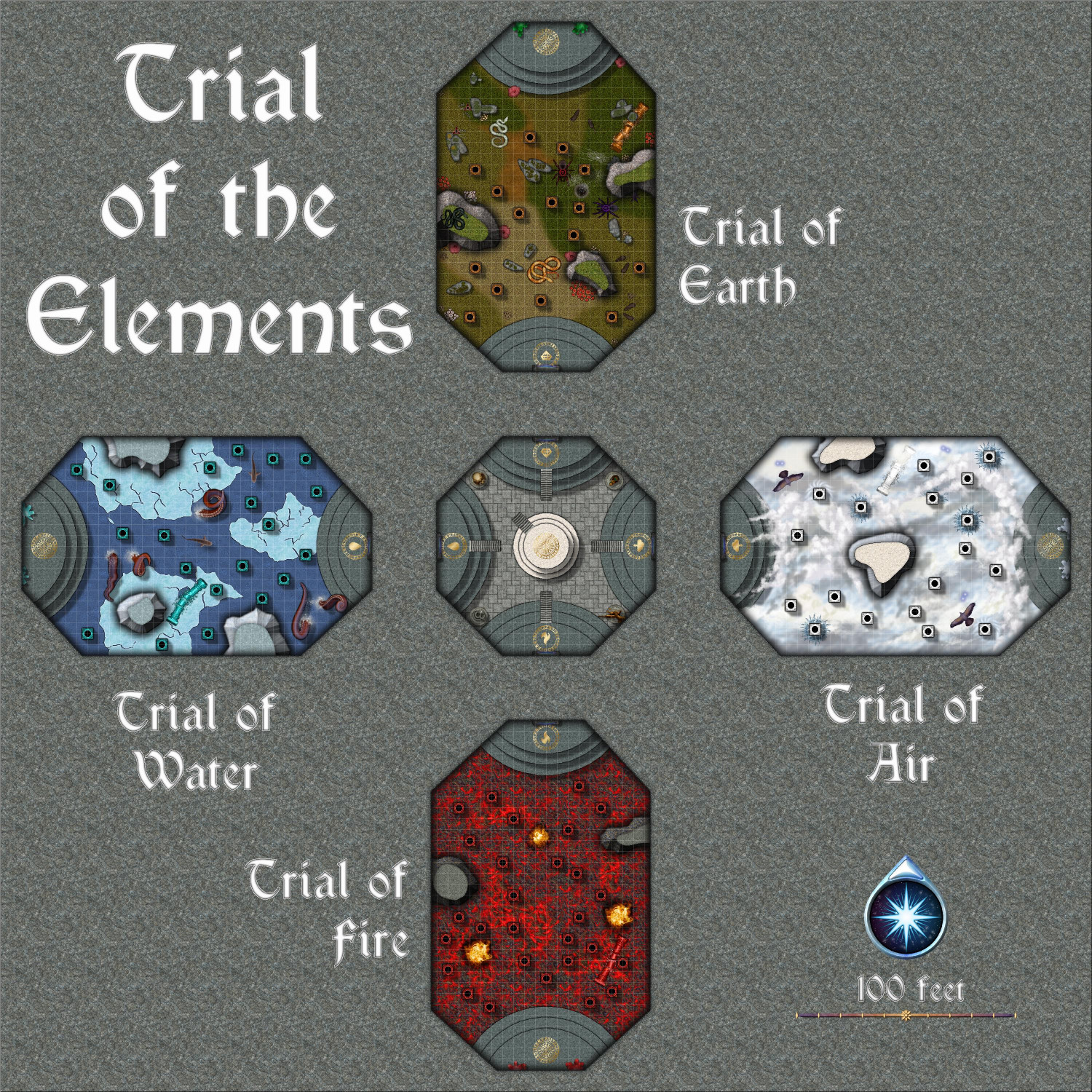
[WIP] Community Atlas: Kumarikandam - SE Tiantang Region
The final map, the Trial of the Elements. This can be linked to from two places: the center of the labyrinth in the Huo Yu Bing Caverns, and the dais in the Ritual Room of the basement of the Zhao Guang Si Temple.
No toggles. The dais in the middle of the central room can link back to the basement of the Zhao Guang Si Temple.
Description
The Trial of the Elements
Final Initiation for the Monks of Zhao Guang Si
Apprentices studying the Path of the Morning Glow at the Zhao Guang Si monastery have two final initiation tests required to graduate and take their place among the ranks of the other monks.
Students must first pass the Trial of Fire and Ice within the Huo Yu Bing Caverns to access the teleportation portal that will take them here, to the Trial of the Elements. That first trial might result in the student recovering a blue shard that protects them from cold damage, and a red shard that protects them from fire damage. While neither is required to pass the trials, both will make it easier to pass both the Trial of Fire and Ice as well as the Trial of the Elements.
The Central Room
After completing the Labyrinth of Fire and Ice in the Huo Yu Bing Caverns, initiates will be teleported into this octagonal room, where they will appear on a dais of white marble in the center of the room.
At the compass points of this room are four daises made of gray marble. Each has a brass circle with runes inscribed on it, with a different sigil for each. On the eastern dais, the sigil is of a cloud with a lightning bold. On the southern dais, the sigil is of a ball of flames. On the western dais, the sigil shows a drop of water. On the northern dais, the sigil is of a cut gemstone.
There are four statues along the remaining four walls of the octagonal room. The statue on the northeastern wall is of a crouching cat. On the southeastern wall, the statue is of a winged person. The statue on the southwestern wall is of a serpent, and in the northwestern wall, it is of a horned skull.
When anyone first appears on the central dais, the horned skull statue in the northwestern corner will speak and say:
“Welcome! Before the Trial of the Elements, present thyself before each of us for a battle of wills.”
The initiate may approach the statues in any order. For the willpower battle, the Game Master will roll a d20+5. The initiate then rolls a d20 and adds their Wisdom bonus. If the initiate has the highest score, they win the willpower battle and achieve a magical effect for the next 24 hours. If they fail, there is no harmful effect, but they do not achieve the magical bonus and may not try again.
The following gifts are available:
• Cat Statue (NE corner): The initiate benefits from a Spider Climb spell for the next 24 hours.
• Winged Person (SE corner): The initiate benefits from a Feather Fall spell for the next 24 hours.
• Serpent (SW corner): The initiate is immune to poison and diseases for the next 24 hours.
• Horned Skull (NW corner): The initiate is immune to electrical damage for the next 24 hours.
Once they have completed a battle of wills with each statue, the horned skull statue will speak again:
“Present thyself on any dais to begin that trial of the elements.”
Initiates may embark on the trials in any order.
The Trial of Air
When the student reaches the top of the dais on the eastern wall, a teleportation portal on the wall will glow with a purplish light, and the horned skull statue will speak:
“If thou art ready to begin the Trial of Air, step now through the portal.”
Stepping through the portal deposits the traveler on a dais on the eastern wall of a long room that is 160 feet by 100 feet. The room is filled with clouds that cover the floor, making it impossible to see how far down the floor is. Ornate columns carved to look like clouds sprinkle the room.
Those wishing to cross the room must make a standing long jump from one column to the next. As gravity is magically lighter here, the initiate can move a full foot for each point of Strength they have. When they land on the next pillar, they must make a Dexterity check against moderate difficulty to avoid slipping off and falling.
The floor is 30 feet below, and anyone who slips will suffer falling damage unless they can fly or are protected by the Feather Fall spell. Climbing back up a pillar requires a Strength check of moderate difficulty. Success is automatic if they are under the effect of Spider Climb or a similar ability.
Each pillar has a one in six chance of delivering a bolt of lightning that deals 1d10 electrical damage unless they are immune to electricity. In addition, the room is protected by a pair of creatures that magically manifest as a flying creature, which may be hawks, harpies, small air elementals, or similar creatures.
There are a few outcrops in the room. Landing on one does not require a Dexterity check to avoid slipping off, and they do not deliver electrical damage.
Visitors are permitted to use any magical, trained, or innate abilities to travel across the room, including flying if they can do so.
If they reach the dais on the eastern wall, two milky white crystals are on either side of a teleportation portal. Retrieving a shard from either crystal will activate the teleportation portal, allowing them to return to the central room and embark on the next trial.
The Trial of Fire
When the student reaches the top of the dais on the southern wall, a teleportation portal on the wall will glow with a purplish light, and the horned skull statue will speak:
“If thou art ready to begin the Trial of Fire, step now through the portal.”
Stepping through the portal deposits the traveler on a dais on the northern wall of a long room that is 160 feet by 100 feet. The floor is covered with molten lava, with ornate pillars rising ten feet above the lava.
Those wishing to cross the room must make a standing long jump from one column to the next. As gravity is magically lighter here, the initiate can move a full foot for each point of Strength they have. When they land on the next pillar, they must make a Dexterity check against moderate difficulty to avoid slipping off and falling.
If they slip, they fall ten feet into the lava, taking 2d6 damage from the lava each turn that they remain in it, unless they are immune to fire damage, such as possessing a red shard from the Trial of Fire and Ice. Climbing back up a pillar requires a Dexterity check of moderate difficulty unless they benefit from the Spider Climb spell or have a similar ability.
There are a few outcrops in the room. Landing on one does not require a Dexterity check to avoid slipping off.
The room is protected by three small fire elementals who will attack at random and without coordination.
Visitors are permitted to use any magical, trained, or innate abilities to travel across the room, including flying if they can do so.
If they reach the dais on the southern wall, two bright red crystals are on either side of a teleportation portal. Retrieving a shard from either crystal will activate the teleportation portal, allowing them to return to the central room and embark on the next trial.
The Trial of Water
When the student reaches the top of the dais on the western wall, a teleportation portal on the wall will glow with a purplish light, and the horned skull statue will speak:
“If thou art ready to begin the Trial of Water, step now through the portal.”
Stepping through the portal deposits the traveler on a dais on the eastern wall of a long room that is 160 feet by 100 feet. The floor is covered with icy water, with ornate pillars rising ten feet above the water.
Those wishing to cross the room must make a standing long jump from one column to the next. As gravity is magically lighter here, the initiate can move a full foot for each point of Strength they have. When they land on the next pillar, they must make a Dexterity check against moderate difficulty to avoid slipping off and falling.
If they slip, they fall ten feet into the cold water. For each turn they remain in the water, they must make a Constitution check of moderate difficulty. If they fail, they take 1d6 damage unless they are immune to fire damage, such as possessing a blue shard from the Trial of Fire and Ice. Climbing back up a pillar requires a Dexterity check of moderate difficulty unless they benefit from the Spider Climb spell or have a similar ability.
A pair of sharks patrol the waters and may attack anyone who falls in. In addition, six tentacles rise above the waves throughout the room and may attack anyone on a pillar.
There are a few outcrops in the room. Landing on one does not require a Dexterity check to avoid slipping off, and the tentacles mysteriously will not attack anyone on an outcrop.
Visitors are permitted to use any magical, trained, or innate abilities to travel across the room, including flying if they can do so.
If they reach the dais on the western wall, two bright turquoise crystals are on either side of a teleportation portal. Retrieving a shard from either crystal will activate the teleportation portal, allowing them to return to the central room and embark on the next trial.
The Trial of Earth
When the student reaches the top of the dais on the northern wall, a teleportation portal on the wall will glow with a purplish light, and the horned skull statue will speak:
“If thou art ready to begin the Trial of Earth, step now through the portal.”
Stepping through the portal deposits the traveler on a dais on the southern wall of a long room that is 160 feet by 100 feet. The floor is covered with grass, but anyone can easily see serpents, rats, and giant spiders throughout the room.
If they slip, they fall ten feet onto the ground, taking falling damage unless they can fly or are protected by a spell or ability like Feather Fall. Climbing back up a pillar requires a Dexterity check of moderate difficulty unless they benefit from the Spider Climb spell or have a similar ability.
While on the ground, they will be attacked each turn by a snake, rat, or spider. The snakes and spiders are venomous, and the rats are diseased. An attack that causes damage requires the victim to making a Saving Throw against poison unless immune to poison through a magical effect or ability. These creatures will not attack anyone on a pillar.
There are a few outcrops in the room. Landing on one does not require a Dexterity check to avoid slipping off. Each outcrop has one snake on it, but new snakes will not climb up if the snake on them is slain.
Visitors are permitted to use any magical, trained, or innate abilities to travel across the room, including flying if they can do so.
If they reach the dais on the northern wall, two bright green crystals are on either side of a teleportation portal. Retrieving a shard from either crystal will activate the teleportation portal, allowing them to return to the central room and embark on the next trial.
Graduation
If an initiate has retrieved a shard from each of the four Trial of the Elements rooms, the horned skull statue will speak, saying:
“Congratulations, graduate. You have passed the Trial of the Elements. Stand on the dais in the center of the room with all four shards, and you will be transported home.”
Doing so will result in being teleported to dais in the Ritual Room in the basement of the Temple of Zhao Guang Si.
-
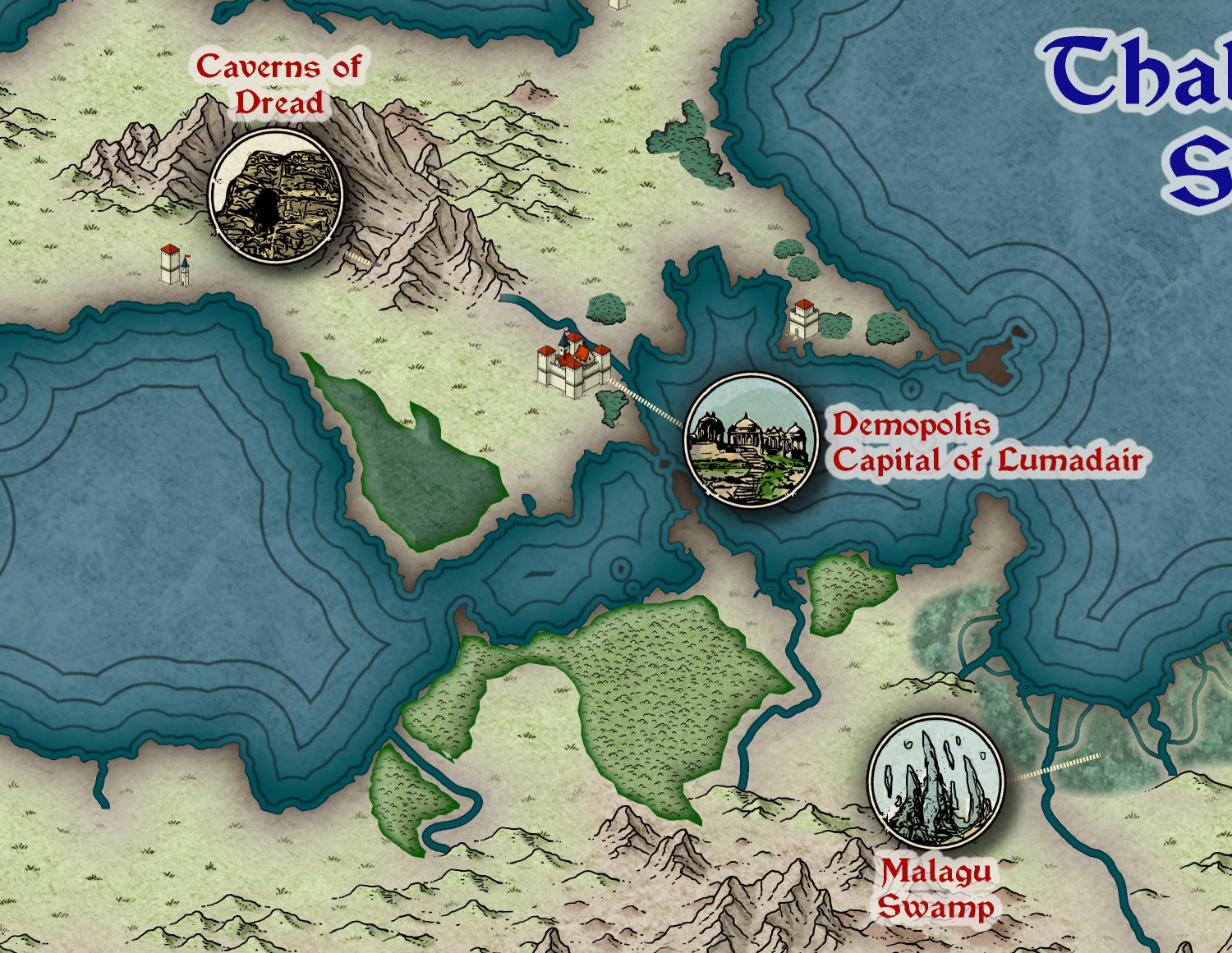
[WIP] Republic of Lumadair (Ancient Realms Revisited)
I have previously done the Republic of Lumadair, a portion of my campaign world, in many different styles. (There's an album in my galleries showing the different approaches.) I find it helpful to compare styles with a consistent coastline and terrain.
Anyway, here's a first pass at trying it with the new Ancient Realms Revisited annual.
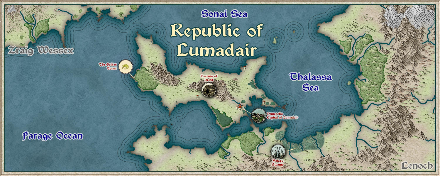
I ended up using tower symbols instead of cities to show the major unnamed cities. I've only done a few of the icon symbols for major points of interest, though I can do more. Instead of putting the icons exactly where the locations would be, I put them off to the side with a dotted line to the actual location (similar to how I approached my Modern Journeys map).
This sort of forest approach rather than individual symbols isn't my favorite approach, but it's growing on me. For the coastal cities, maybe I should trace the coastline rather than being more freeform? Ralf brought in some Mike Schley symbols (Asian settlements) in his video tutorial, so maybe I will try that with Mike's tree symbols. I'm worried, though, that those tree symbols would make this look too much like a knockoff of Mike's overland style and not its own thing.
I did one custom symbol of a dragon, but I'm not thrilled.
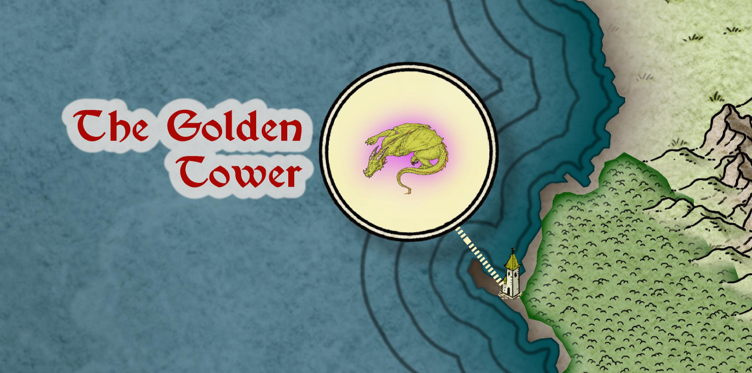
I used a parchment background but maybe a solid color would be better? (The icon background is on a separate sheet, so I could see if a texturize effect helps.) Or I could put a tower icon as the main icon with a dragon over it. If anyone knows of better dragon symbols to use, let me know. (I thought about the heraldry icons from CA15, but I'm not so sure.)
-
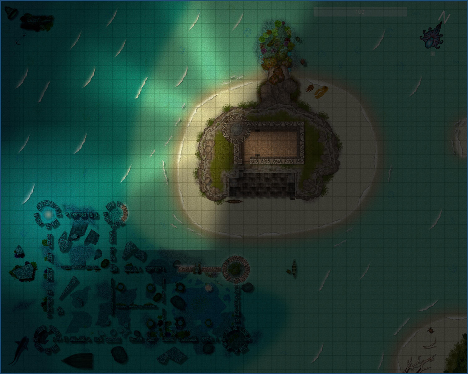
[WIP] Marine Dungeons Lighthouse (more May Annual Stairs & Steps)
And here's the lighthouse at night. Fires are kept burning all night, reflecting off of mirrors (or polished sheets of metal) to cast light away from the mainland, though a window allows for some light to spill into the courtyard.
By night, a glow from the sunken ruins reveals a magical portal beneath the waves....
-
Wish List: City/Dungeon Top-Down Mountain Peaks, Ridges & Crags
So when Sue asked if I had tried stacking cliff symbols, I had...but always in the same direction, which gave me elevation but didn't give me ridges. I just tried flipping the Forest Trail cliff symbols so they're back-t0-back -- and these are exactly the sort of ridge lines I was imagining.
These symbols blend together so beautifully. Truly amazing, Sue! Very excited to start planning a mountain village.


-
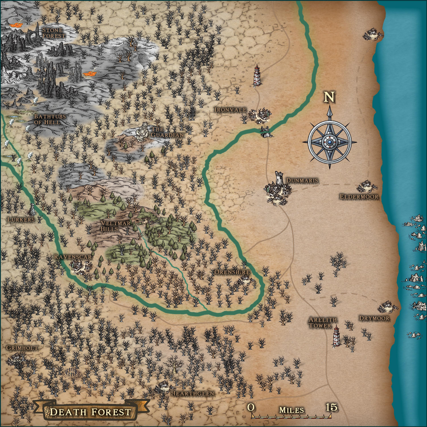
Community Atlas - Fonlorn Archipelago - Bleakness - Death Forest.
Here it is with the missing asset deleted.