WIP: Irish-themed islands
For background information, the world I'm mapping is an attempt at a loose revision of the 6th century which will assume that mythological events and the places that they refer to are real, though of course the exact version of the mythological events will be different. At present I'm mapping something like the "world-system" that existed around 12th century b. c. e., which comprises a rough equivalent to the area between India and Spain in our world.
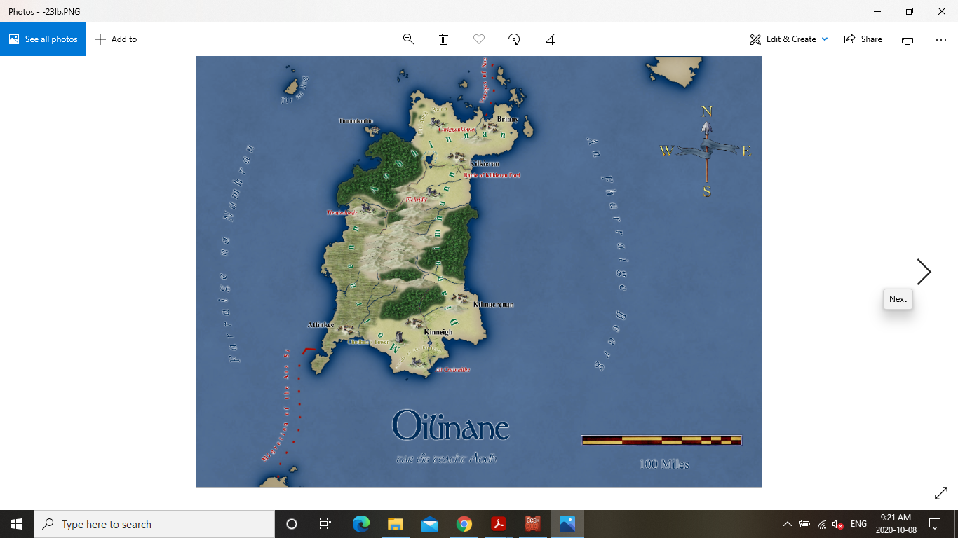
A little while ago, for a Facebook challenge, I presented the following island which was based very roughly on the geographical region of Connacht, in Ireland, although in retrospect its too large. There is a second island, to its south, that I originally intended to base off the old Irish province of Ulster, but am now thinking of dividing up between Leinster and Munster, and then having Ulster on the mainland even further to the south. I should note that the region is being mapped in the southern hemisphere, so that south is toward the pole, which should explain my thinking. These three areas, would then have roughly the same area as Ireland, though Leinster and Munster would be smaller, while Connacht would be much larger than it was historically. Clearly I should have planned better, but I just kind of dove into the challenge without thinking about all of these intricacies.
Anyway, regarding this island, the straightness of the eastern coast bothers me a little, and I had explained it away by referencing the straight coasts that do exist in the world (ie. the Iberian peninsula). I can't shake the feeling that it still looks unnatural though. I'm wondering what others think?


Comments
I think that your map looks great, including the East coast. Most of the UK East Coast is pretty straight as well.
Didn't really notice the straightness of it until you pointed it out. It's fine as it is.
I agree with the others - I didn't even notice that it was "straight" until you pointed it out, and think the map looks fabulous.
I didn't notice the straightness either. And if you think they don't exist, think again. This is almost the entire west coast of France - a relatively long section of coast.
That's funny... I thought this section of coast looked like Israel... there really are a lot of places in the world with a straight coast. I'm feeling better about it.
I think this unnatural aversion to long slightly curved sections of coast we all seem to have may be why we find it so difficult to generate natural looking coastlines.
Straight coast tends to happen where the hinterland is rather flat and geologically homogenous, so that erosion doesn't eat little coves into it over time in the softer rocks.
It would only be unnatural to have long straight bits of coast if all the coast in the world was like that.
There is a family of things called multifractals which change their parameters over their definition space. Some parts are smooth (and locally straight if you cut them with a coastline) and other parts are very crinkly. A map that's all Norway or Greece is just as unnatural looking as one composed of all straight edges.
A common complaint about unnatural-looking maps are ones that just happen to closely follow the outline of their frame. You know, those weird rectangular maps. It's really silly if someone draws a square peninsula attached at one corner or puts in a square crater. You know, like Iberia and that crater in Arizona. Hundred-mile straight coasts and right-angle things are much more common than people like to think here in the real world.
The amount of detail that's visible in a coastline can help to inform you about the scale of the map.
Thanks everyone for the comments. I'm going to keep it as is and continue work on the island to the south of this one.
@Loopysue That is really interesting about the hinterland being flat (and seems obvious now that I've read it).
@jslayton A really amusing way to point this out. I had some inkling of it, but it seems clearer now.
Here is a map of the work I've done so far on the southern island. I ran the region through the One-Day Worldbuilder, as I've been doing this for regional maps and it really helps me define where elevation should go better than coming straight from FT3. I then did a contoursm into CC3 and referred to a tracemap for mountains and rivers. Finally, I've put borders in to denote ethnic groupings.
That's quite an interesting look. I had never envisaged Spectrum being used with political borders, but it seems to do ok :)
I like it! I've always favored coloring or shading different political/cultural regions rather than putting lines around them. For me, it's a much clearer presentation.
I'm thinking its a simple matter to just hide the sheet if it doesn't seem to be working once I put more details in. I mostly wanted the regions to guide my placement of things.
When you put more details on the map, if the borders really start to look odd, try making them a lot thinner first before you get rid of them. Sometimes it works. Sometimes it doesn't.