

Expanding Endless Sea of Ice FR
 Frosty
🖼️ 22 images Surveyor
Frosty
🖼️ 22 images Surveyor
Hey folks,
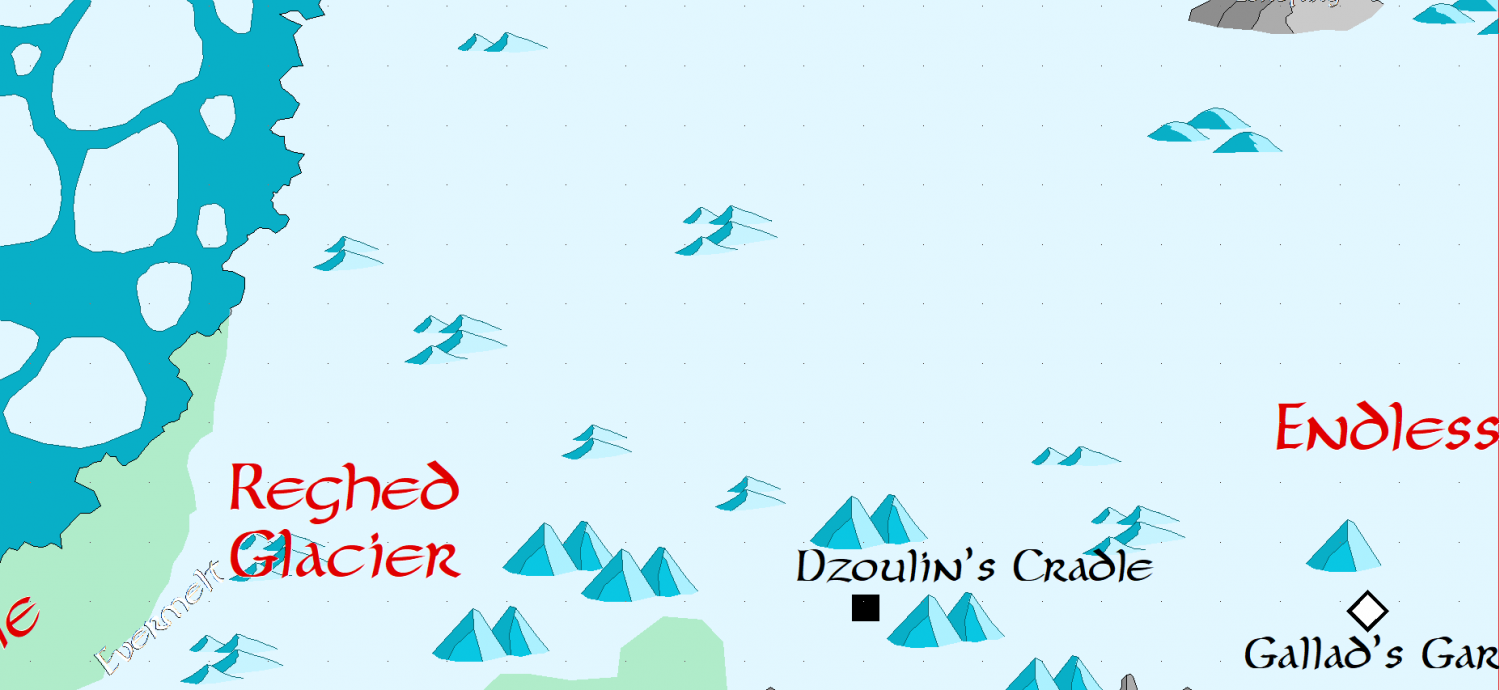
Looking to expanding the FR Atlas map for the far Northern Area of the Endless Ice Sea, in particular the area along the Western Coast.
First I want to use the right symbol set so that it matches. I did see the link to the FR Atlas site and I did see there was a link to CC2 Symbols and claims they come with the Atlas. Where are those symbols installed so I can make sure to use them?
Second Going to start looking for any content Wizards of the coast has put out in the area to add to the map and I imagine I will point to any published items for detailed areas they have created content for. Any pointers to things that people are aware of I should add would be great.
Example: DNDBeyond has an adventure called Prisoner13 which has a map of a place called "Revels End" In words it describes it as being in this area but just has a small map showing that it is along the coast. This is the prison we also saw in the movie "Honor Among Thieves."
Might take me a bit to figure out how the hyperlinks work and make it look right but I am mainly doing it for a friend who has created a campaign in this area and thought while I do it perhaps i could give back to the community and even Wizards if they want it.
Comments
I'm not sure how much information you may have access to beyond the FRIA (which is something I don't have), but there's a lot more detail in this general region of Faerun than the map you've shown here. Of the more recent products, I suspect only "Icewind Dale" will add much, and that chiefly for the Ten Towns region, towards the coast, but you might be advised to see earlier products as well, of which "Forgotten Realms, The North: Guide to a Savage Frontier" (for D&D 2e) might be a useful starting point. There were various subsequent TSR products that included bits and pieces about the area too, though it's been over seven years since my own detailed researches into the old publications covering the northern Sword Coast region, and I'll have forgotten more today than I can easily recall quickly, I'm certain!
If you can find a copy, Karen Wynn Fonstad's "The Forgotten Realms Atlas" (also by TSR) is definitely worth seeing too, since it's one of those rare publications that treats Toril as a round planet, not a flat map-plane, and shows a lot more of the, as it turns out, massive polar ice cap the Endless Ice Sea feeds north into. Detailed additions are though very few beyond that. The mapping style is very different, and I found it gave a fresh perspective on the planet, and this area, in general.
Hmm I have the savage frontier and my search this morning I found the Rime one in Icewind Dale and saw it was very mapped out so I am going to focus North of that and just mark those spots and "point" to those resources. The other Atlas you mention is not one I have..I think Oh wait I might.. I have an old box set that might be that.
Hi.
I did see the link to the FR Atlas site and I did see there was a link to CC2 Symbols and claims they come with the Atlas. Where are those symbols installed so I can make sure to use them?
I don't know if there's an "official" answer for this, but here's a few pointers.
First, I couldn't find the symbols after installing FRIA, but you can download an installer for CC3 (not "plus", more on that) from the support page for the FRIA site. There's some certificate issues with the link, so your browser might hesitate. If I manually paste it and open it in a new tab, Chrome allows me to tell it I know what I'm doing and allow the download.
Then comes the biggest hurdle: that installer expects to see both FRIA and CC3 (and not CC3+) installed, so it might refuse to install it. Unless, of course, you have the non-plus version of CC3 installed. You might be able to unpack the installer in some other way, but I now realize that I don't know if there's legal stuff that would advise otherwise. So I'll propose another option..
CC3+ is capable of opening the maps from FRIA with no problems, and since you own both products, you can simply open the maps from CC3+ and edit away.
I will say that I encountered a small problem with symbol fills if I try to reopen them in FRIA.
Finally...
If you can find a copy, Karen Wynn Fonstad's "The Forgotten Realms Atlas" (also by TSR) is definitely worth seeing too
The PDF is available at DTRPG:
And also:
You can see the index for both products from the preview, but no "list of maps" sadly.
They're still sitting on my wishlist, so I don't know if you'll find the maps you're wishing for... but do let us know if you do buy them or find your physical copies. :)
- https://preview.drivethrurpg.com/en/product/17554/fr5-the-savage-frontier-1e
- https://preview.drivethrurpg.com/en/product/17543/the-north-guide-to-the-savage-frontier-2e
- https://preview.drivethrurpg.com/en/product/16832/fr14-the-great-glacier-2e
- https://preview.drivethrurpg.com/en/product/16816/fr9-the-bloodstone-lands-2e
Different but related, I have had a huge appreciation for Karen Wynn Fonstad's work for a long time. We lost her and her talents way too soon.Aye I been opening the map in FRatlas looking at the name.. finding it and opening it in CC3+ then saving it elsewhere and editing it. I am looking at the new Icewind Dale Map from that campaign set which I think Mike Created. I may compare the style used and see if I can duplicate it to expand things East and a little South through the Spine of the World and then do a few "zoom in" smaller scale maps of areas.
I glanced at FR14 the Great Glacier and there may be some interesting content there but the maps are the ones also in the FR Atlas so think I will stick with that. Besides it sounds like the PDF you get on drivethrough is not great due to the grayness of pages.. Flip allowed me to look at it...and I may buy the printed version
Did you figure out the symbols?
Can you just copy them and create new symbol?
Honestly I got distracted going down 12 different paths to look at styles.. I am guessing it is Mike's overland mapping style..I noticed on his site he had a downloaded JPG of Northwestern Faerun that used the same style and covered more of the region though I am not interested in the southern part at this time. Just a snippit of Mike work as I am not going to share the whole thing as that feels well wrong.
Huh.
Then comes the biggest hurdle: that installer expects to see both FRIA and CC3 (and not CC3+) installed, so it might refuse to install it.
... as usual, Profantasy being awesome time and again.
The symbols can now be downloaded for CC3+.
https://www.profantasy.com/fratlas/tech.htm
Thanks!
That only opened a PDF for me, not the FRatlas symbols????
Perhaps this style is Fantasy Realms Re-imagined from 2024 it is close at least
That's odd... I just tried my own link and it leads me to this page:
Oh I meant the CC3+ one opened a pdf, not any symbols.
For me Don it downloaded an EXE for CC3+ that I than ran which opened CC3+ at the end
Ihave it halfway figured.
Copied the link, then it opened the exe.
It attempted to install, but I think I moved my atlas position. So I will have to reinstall the atlas to the normal directory.
Instead of going to the North or creating new maps I did in fact use FR Atlas and just updated map with locations etc. While this is working for me some day I think I will want to use a different style than what the Atlas uses.
Having said all the right now I am looking at creating a.. map of an old monastery on the top of a mountain plateau. This place is old partially ruined and surrounded by cliffs. Thinking I will have a gorge going down the certain of the plateau which has a river within i and one can se a river pouring out of on side into a waterfall. There will be a switch back trail up along one cliff side and an elevator on the other side that allows the inhabitants to raise supplies, cattle, or people via the large elevator system.
Up top there will be some cross, fenced in area for live stock a couple small buildings/towers and then one multi building with bridges connecting section with one part built out over the cliff face. Have all of this sketched out on paper but this feels like an area map but also a large scale battle map. I imagine the large building at least will need to be a separate multi layer map.
As normal other than drawing on paper and making notes I am struggling where to start. I have made one attempt using an overland style and scrapped it. Any thoughts on how I should start Scar Top or Hawk's Erie or both.. have not decided on the name.
Having said all the right now I am looking at creating a.. map of an old monastery on the top of a mountain plateau.... As normal other than drawing on paper and making notes I am struggling where to start. I have made one attempt using an overland style and scrapped it. Any thoughts on how I should start Scar Top or Hawk's Erie or both.. have not decided on the name.
I kinda think this would work well with Forest Trails and Darklands City together, unless you're going for a more illustrated look like Mike Schley's. Check out this thread where I put Forest Trail cliffs back-to-back to form mountain ridges and placed some Darklands City structures to provide a sense of scale. Further down the same thread, I did the same with the snow-covered cliffs from Winter Trail and snow-covered buildings from Winter Village. And you can check out another example in this thread where I did the same thing with the cliffs for the lair of a coven of forest hags.
I will check it out I know I used Darklands before in a city that I never quite finished as it was just something I was doing to past the time. Forest Trails I think is the one meant for the parchment strips.. I recall working on one but never using it.. now I need to find it.
No shadows yet and might have to figure out how to round the edges some. Open area on the north I want to do a sort of switch back trail going up the mountain. Thinking shrink cliffs and use those back and forth and paint the ground brown or something.. any things.. Kind wish the crevice was straight down view.. going to put a bridge over that..
I've never been able to do rounded edges with this style or with Mike Schley's Cliffs. Please teach me when you figure it out. 😅
LOL i tried mind bending technology like from the old movie Wanted but that has not worked yet. I will let you know. There are other styles with "roundier" edges but they do not loo as steep
I did make some changes to one cliff side making it rise instead of fall to try and deal with some of the challenges. But the challenges still persist.
I do not like the way this meeting of cliffs looks..perhaps I can stretch the bottom cliff up to sort of merge into the top one.
Have you thought of trying to do this with the Forest Trail cliffs pieces instead?
It has crossed my mind I liked the steeper cliffs of darklands but I could stack the cliffs to give that feel I imagine I did take my first shot at the switch back trail using forest trails and there are some rough spots and maybe I will make one more loop and of course will add dirt to the ground to hide the grass and make this part more like a trail.
I still really don't like the crevice .. I will see if I replace a normal cliff section with stack or enlarged forest trail cliffs what it looks like.
Not that I am surprised Sue but I think you are correct. Started working on replacing the cliffs.. any thoughts about a better crevice?
If you are using the Forest Traila cliffs, you could use the darker versions of the cliffs for the crevice, or the river bank symbols (though that probably won’t be as effective).
Yeah tried the banks and did not look the way I want...I thin I need a straight down view of a crevice if that makes sense. I did use the darker cliffs for the upper plateau.
There's a much better sense of form going on now.
The City Cliffs were designed to be spiky-cornered, but if you have a long bend you can get them to bend around it in short sections by clicking more times around the curve where possible.
While the cliffs still need some work and think I am going to make another loop in the switchback going to research the crevice see if I cna get that and the bridge over it done then work on the other buildings up top and maybe on the right side another layer of cliff that I can out some cave mouths in for I think Wyverns that patrol the gorge though maybe I should go with something that makes nests.