

Difficulty with choosing what terrain type to put where on my map (Overland Mike Schley style)
 PapaJohns57
Traveler
PapaJohns57
Traveler
This is the first map I'm creating with CC3+ without a tutorial. Many things might look a bit odd, but that's mainly due to my inexperience. The main problem I'm facing right now, is choosing which terrain to put where on my map. Before making this map, I've only ever used the default "Overland CC3" style and this is my first time using the "Overland Mike Schley" style. Even though I like this style, there are less terrain options than the default style has and I'm not sure how to make these terrains work well together.
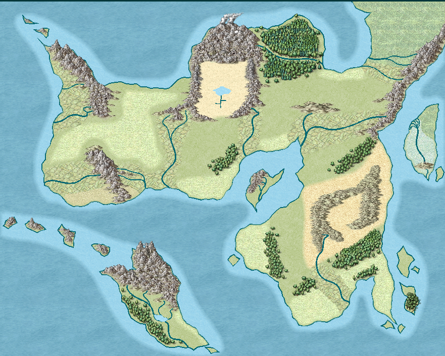
For example, I tried to put farmland around most rivers, but it feels a bit odd.
Plains are another big issue I have. Whether I put them near the shore or more inland, whether I make them big or small, it always looks off. (The plains here are just examples to show off my issues, this isn't what I want the final version to look like.)
I also don't really know how to make these terrains look good when they're right next to each other. For example, the island off to the right, I wanted to place both a swamp and a marsh there. I still need to put more vegetation there, but as it stands now, the border between the two doesn't look good.
I guess I'd like to ask you all if you have any advice where I should put which terrain type and how to make it look good?
Thank you all in advance!
PS: Some places on the map are influenced by magic. That's why they might definitely not be realistic, but I still chose to place them there.

Comments
You're worldbuilding here, even if it isn't a whole world. That's a huge task if it's done properly, but most of us manage with a very basic understanding of how things work on a very general level.
Manmade terrain, like farmland, will tend to be at the lower altitudes where there is fertile soil and water, so the river idea isn't as bad as you think. but perhaps it would be easier to place the farmland if you add the settlements and roads, since no one is going to farm a fertile valley that is hundreds of miles from the nearest large town, and which has no roads to transport the food to that town.
Settlements themselves will tend to be on the coast where there is good fishing or good access to oceanic trading routes, preferably both. Or they will encroach inland up the larger rivers, particularly if there are resources to be had - like timber, mineral ores or just to farm the land to feed a growing city at the mouth of the river. They can also arise along major overland trade routes, particularly where these cross natural barriers like rivers or either side of a mountain pass.
Wherever man isn't building cities or farming, the rest of the land will probably be far more dependent on climate and altitude. After all - why waste magic on land that is no use to man?
Forests have tree lines that respect both altitude and latitude. Deserts, with a few really obvious exceptions, tend to appear at 30 degree latitudes on Earth because of the lack of rainfall where the Hadley Cell circulation causes descending air. https://en.wikipedia.org/wiki/Hadley_cell Deserts also appear in places like Chile over a much wider range of latitudes, where a cold sea current flows up the South American coast from Antarctica and fails to fill the air with moisture, causing little or no rain to fall on that side of the Andes.
That's more than enough to be thinking about, so now on to the practicalities of making that swamp and marsh terrain work together.
Both of those terrains are placed on the same sheet by their respective drawing tools, called LAND FEATURES. So where they overlap the Edge Fade, Inner doesn't fade the edge of the individual polygons, but only the outside edge of both the polygons taken as one mass
The solution is to add a new sheet either just above or just below LAND FEATURES and call it something suitable, like LAND FEATURES 2, copy the sheet effects from LAND FEATURES to the new sheet, ok that and then move either the marsh or the swamp texture to the new sheet.
Here I have moved the swamp fill to the new LAND FEATURES 2 sheet, which places it above the marsh and fades the edge.
If I want them the other way around I might move LAND FEATURES 2 above LAND FEATURES in the sheet list, or move the polygons, each to the other sheet.
Thank you for the quick reply. You've answered a lot of my questions (even one I didn't ask yet).
You're right, I should definitely place my settlements first and my farmland later on.
The extra sheet definitely fixes the swamp/marsh issue.
You've been a big help with the terrain types. The only thing I'm still struggling with right now is what I should do with the plains. Most of the area on this map was supposed to be plains. It didn't feel right to cover most of the terrain in this terrain style however as its colour differs quite a lot from the farmlands. This might just be personal preference though so I don't think I can ask any advice about this.
Still, you've helped me a lot. Thanks again!
You're welcome :)
If its a plain, its a plain. Don't be afraid to map it as it is. There are plenty of symbol assets in this style to add points of interest across that vast plain. Spend some time looking through the symbols and picking out things you could add to a plain. Maybe paste them somewhere out of the way in the ocean or outside the map so you don't forget what they were or where they were. It's easy enough just to move them into position later, or to delete them if you change your mind.
Have you downloaded and installed the free monthly content for Mike Schley overland? This style is still growing. If you haven't, you will find the single download file listed under CC3+ on your downloads tab when you log into your account.
You're right. It's a plain so I should just make it a plain, simple as that. I'll keep this in mind, that's actually great advice.
It also looks better than I thought, actually. I've yet to delete the farmland, but I tried to use the different "land features" sheets to see how it would look like and that helps quite a lot.
That's true, there are plenty of symbols that will help flesh out the terrain.
Oh, I didn't, actually. Apparently I'm also still on CC3+ version 3.97. I'm downloading both the update and the free monthly content right now. Thanks for reminding me. Just to be safe, updating CC3+ itself won't do anything to my map, right?
You'll be fine. None of the updates will hurt any of your maps.
There's loads of new stuff from Mike Schley for this style. It will be like Christmas for you getting them all in one lot :)
Great, I'll install them immediately then. And you're right, this will definitely give me a lot of new stuff to work with.
Thanks again for all your help!
You could put areas of ruins out in the plains to break it up a bit.
Maybe a few ruined towns, with some ruined keeps and one ruined castle. They tried to make a life out there, but various circumstances got them to leave, or they didn't survive. Or both.
An old road. Solid for a few files, a miles long gap, then a dashed road. So on. So it looks like it was once used, but is now in disrepair.
Great suggestion, I'll keep this idea in mind.
Another idea.
A small group of hills or a mesa with a ruined keep to one side.
That could definitely work, thanks!
There is a lot of good advice here, but I am going to share my experience with the color Mike Schley style. While I have seen some great looking maps posted in that style here, I cannot make maps that look good in this style. I do not think it is a very forgiving style and more recent styles I think are not only superior in terms of the art, but also in how they are built.
The more recent styles have additional style sheets. Since they are annuals, they come with a PDF walkthrough of how to make maps in that style. You also have at least one, usually two, samples of the new style. I have found all of this very helpful when making maps. Additionally, these new styles often contain more sheets and the tools use these new sheets.
In my opinion, the Mike Schley style requires a bit more knowledge of sheets and map making in order to make them look as good as they can be. I think I would be a better map maker if I were to spend the time to really learn how to make a good looking map in this style. At the same time, I can make a map in a different style in less time with less frustration in a less cartoonish style. So, for the moment, I have chosen the later over doing the hard work on trying to master what is essentially the default style.