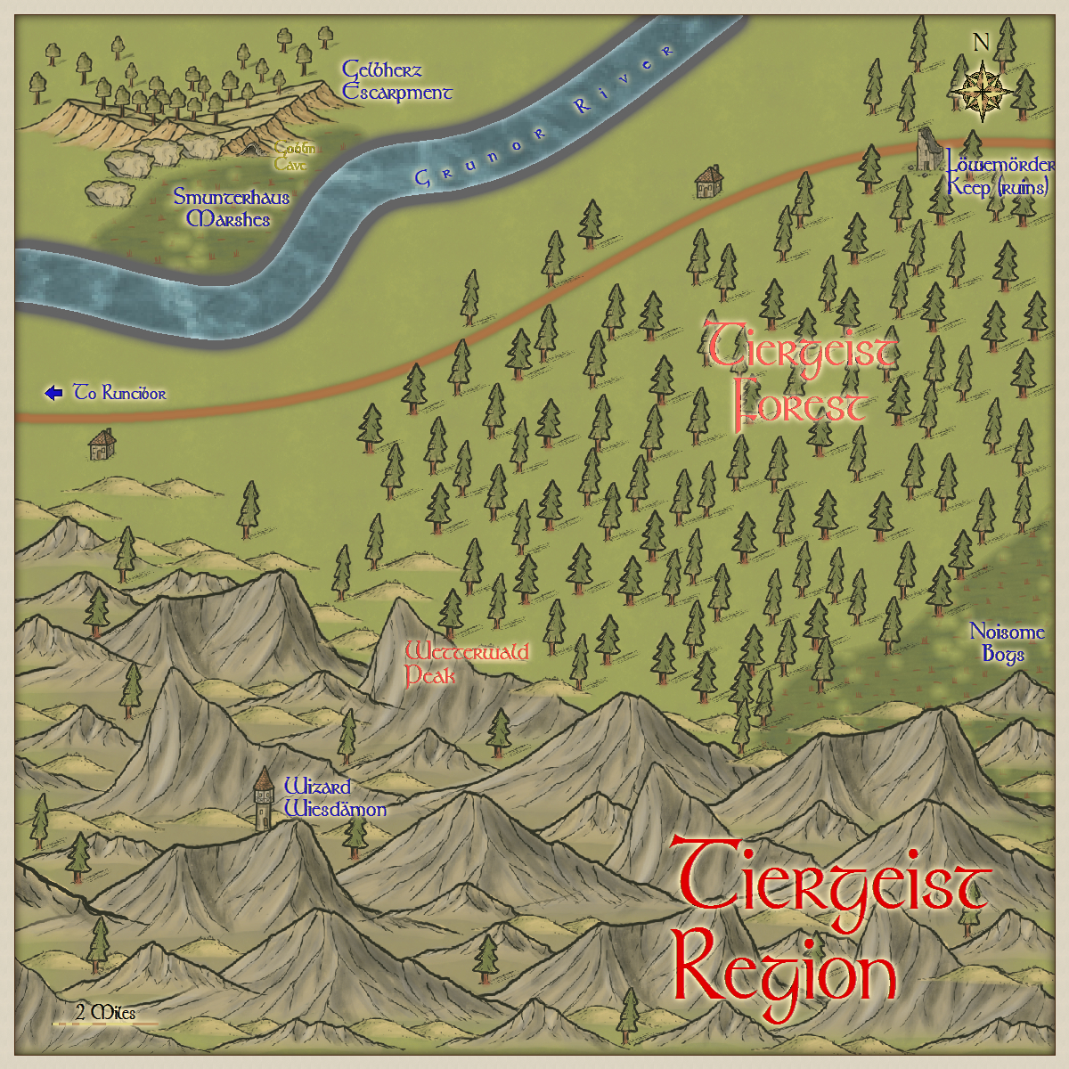
Here is the neighbouring 20x20 mile region east of Runcibor. More features to go in of course. If any have objection to any of the German sounding names, please let me know.
You might convert the "Noisome Bogs" to "Schädlich Sümpfe" (or another near-literal alternative - assuming I've got this bit right myself...) to retain the Germanic labelling theme, but maybe an alternative using "Moor" or "Morast" (= morass; plural Moraste) with a more readily-recognised German term - such as Schrecklich (terrible, dreadful) - might work better?
I wouldn't get, er, bogged down in the names. In particular, whether to call it a bog or a Sümpfe. I get the impression that the idea is to provide a Germanic flavor to the map without actually being in German. The map uses English words for every other label, such as "Region" in the title itself, "Marshes," to the northwest, "Peak," "Forest," "River," etc. Of course, if you want to use German name(s) but have non-German-speaking viewers appreciate the detail, then perhaps consider using the German name with the translation in parentheses.
The Goblin Cave label is a little tricky for me to read, being yellow in a yellow glow, but it could just be the resolution of the image (or my aging eyes). I can see there's a black outline that seems to get a little lost at this size.
Regardless, I the map is nice and I agree with Barliman, it's a good use of Pär Lindström's Local Area Maps style (as he pointed out). I'm a fan (I even use it in my upcoming video tutorials on making local maps from regional ones). I especially like the escarpment and the smattering of trees in the highlands. This map pairs nicely with your Runcibor map.
Here are more details, and a few fixes. Does anyone have any desire for anything else? If not, I will send it off to Monsen. And Dogtag, you have aging eyes.
Quenten, I'm not seeing any obvious difference with the "Goblin Cave" label on your latest version. It still looks a little vague, but maybe these are the Glass Goblins, almost invisible creatures themselves?
In sorting the hills around Wetterwald Peak there seem to have been more problems created with the ordering of the actual mountains nearby now too, which is a particular irritation I've found with this style of symbol myself before now. That lovely watercolour-like fade-out works beautifully as a mist you often don't spot in time hiding nearer peaks with a more distant peak's lower slopes... Good luck sorting this one out!
I didn't put up the version with the amended Goblin Cave, but here it is, with a fix for the mountains. Some of them were on the wrong sheet - naughty me! I have also added a volcano. Ready for Monsen now.
Much better Goblin Cave label, though you might consider moving it a hair to the right and/or down. Where it is right now, the ascender of the "b" in "Goblin" kind of mixes with the escarpment symbol. At first glance, I thought it read, "Coolin" or "Goolin."
The erupting volcano is a neat, creative, touch. Bravo sir.


![[Deleted User]](https://secure.gravatar.com/avatar/c75d9a245b74d9c59be0999ea81ca541/?default=https%3A%2F%2Fvanillicon.com%2F92add7f8c954488718110edc4896ad39_200.png&rating=g&size=200)
Comments
The Goblin Cave label is a little tricky for me to read, being yellow in a yellow glow, but it could just be the resolution of the image (or my aging eyes). I can see there's a black outline that seems to get a little lost at this size.
Regardless, I the map is nice and I agree with Barliman, it's a good use of Pär Lindström's Local Area Maps style (as he pointed out). I'm a fan (I even use it in my upcoming video tutorials on making local maps from regional ones). I especially like the escarpment and the smattering of trees in the highlands. This map pairs nicely with your Runcibor map.
Cheers,
~Dogtag
In sorting the hills around Wetterwald Peak there seem to have been more problems created with the ordering of the actual mountains nearby now too, which is a particular irritation I've found with this style of symbol myself before now. That lovely watercolour-like fade-out works beautifully as a mist you often don't spot in time hiding nearer peaks with a more distant peak's lower slopes... Good luck sorting this one out!
The erupting volcano is a neat, creative, touch. Bravo sir.
~Dogtag