WIP 1000th map competition - Bittern's Rest
 HelenAA
🖼️ 19 images Mapmaker
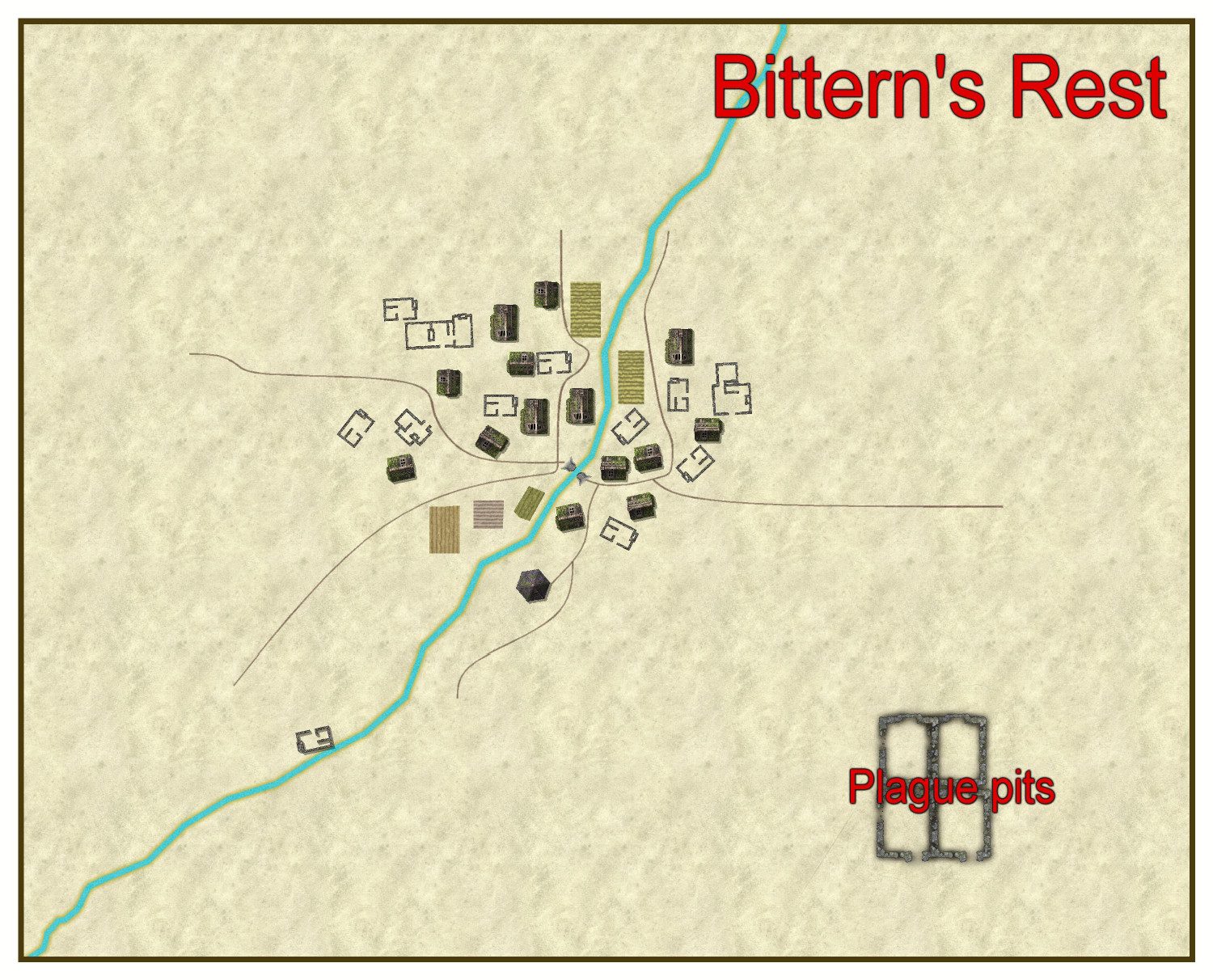
Bittern's Rest had been a town North East of Duck's Ford in Kentoria before plague struck about 80 years ago. Now a large village of 14 homes its inhabitants live in dread of the plague pit complex placed well away from the settlement.
Note. I know there's not much physical geography on the map right now but that's sometimes how I build maps!


Comments
Here's the latest manifestation of the land around Bittern's Rest. I've got a few trees on the map as well now, but as the original map by Wyvern looked as though it was a very dry area I've kept that in mind when placing vegetation. The stream floods massively and provides the only fertile land. I'm going to try to do an underground map focussing on the Plague Pits but as it will be a first for me I don't know if I'll link the two files in time.
Well, the only map with a time limit is the actual competition map, you can add the underground map later when you find the time.
I think it maybe just the parchment style of my area map that's making you think it's particularly dry, Helen. The region is in the tropics, and is not that far from a vast expanse of coastal mangrove swamps and river channels in the River Jackson Delta. Plus the next level map out (Shoenia) suggests Bittern's Rest would be towards the edge of the more farmed lands here, heading west towards the nearby mountains and heavier woods, so if you wanted to add more vegetation, I'd say feel free!
Then again, maybe a lot of the vegetation was also killed-off by whatever caused the plague among the humanoids, so the choices are entirely yours😎.
Thanks for the placing info, Wyvern. My map has undergone a massive sea-change since I posted above, complete with the river/stream running between two hills which makes it much more interesting to re-build the remnants of the town, as I've now no longer have the huge blanks on the map.
here's the latest version of Bittern's Rest. I'm still focussing on the actual village (don't worry, the glows won't be there on my submitted map - though I don't know what is going on with the rendering to .jpg to produce the additional bit of the shadow on the right side of the map).
How big are your render passes?
Use the command EXPORTSETMPPP to find out. If it's only 4000000 (4 million), put it up to 40000000 (40 million). That might help with the horizontal stripes.
That issue in the corner is probably the result of using a Bevel sheet effect with textures that are too similar to the ones behind them. A form of Transparency Acne.
it only had 3 passes before I increased it to 40 million, and it took a very short single pass to process the map a second time. thanks Sue. My bevels don't have fancy effects to them, I make them so big that I can position them so the shape and slope that what is is in the map border is what I want!
I'm acutely aware that I'm doing a vastly different map than those submitted so far, so I thought I'd put it in some kind of context.
I am a proud nerd and as such I do background reading if it's something I feel I need to do. My village is kind of based on what a remote village from the 13th - 14th century in England may have been like in terms of layout, though I'm not copying any actual map. My village is entirely a figment of my imagination.
So don't expect the wonderfully detailed maps that others have [and will have] submitted. I'm simply having fun crafting my best map that meets the criteria set down by Remy.
Lots of vastly different maps from different mappers with different ways of approaching things, that is one of the things that make the atlas (and the competition) great. I love all the great variety of the maps in the atlas, some focusing on visual looks, others on accuracy and yet others on the story they tell.
You should always map the way you want to, and you don't need to justify that to anyone except yourself!
I've actually learned/taught/got to grips with a few command-line things like LIST and editing nodes (yes there are buttons to do the nodes but that means more mouse-work for me) and I wouldn't be without that knowledge now.
Beyond using Transparency to change the strength of a fill, is there any easy way to do this?
The Edge Fade, Inner can also be used to affect transparency with either variable or constant opacities, but I might be getting the wrong end of the stick here.
Do you mean change the colour intensity or how light/dark the fill is (without also making it transparent)? You can use Colorize or Adjust Hue/Saturation sheet effects to do that.
I'll have a bash at Colorize, and see how I get on with that. Thanks.
two problems in one. This morning I redrew the what I'm using as fertile land in the valley and now I can't do an Edge Fade Inner or even Blur on it and the stream is not showing up - despite the sheets being the right way around. As the redrawn shape is so substantially different to its predecessor, I really don't want to try to redraw it unless I have to and my skill with editing nodes is patchy and erratic which makes me even more reluctant. I've checked the layers and thawed all of them to no avail.
It might be the order of your sheet effects. Try moving Colorize to the top of the list.
If that doesn't work, please upload the current FCW so we can see what the problem might be.
just had a brainwave to check which sheet I'd drew the damned shape - and I found somehow it had landed on the background sheet. My question is now how on earth didn't the stream didn't show up????
Is the stream on the correct sheet?
yes it was, so how the blazes could it be hidden by something at sheet level 0 when the stream is at sheet level 12????
Just placed some small-scale symbols that landed on the Symbols sheet and created some Tolkien like monsters just by the Wall Shadow settings! I'm getting into the more weird side of the competition, but I won't run out of time.......
how do I best use the number label thing? I've tried on an old version of the map but didn't get any numbered list.
If you mean adding a series of number labels as text onto your map, you just click the number labels button Number Label and then either hit enter if the number shown on the command line is correct, or replace it with the first number you need instead, and then place the labels on your map.
It's easiest if you make sure the properties for the size and font for the labels is correct before you start that, although you can change it once the label's placed, as normal.
There's a live mapping session here, where Ralf demonstrates the automatic indexing, but that seems like a lot of bother for a village map.
unfortunately my village has a few sites, which, if I just type the labels in a font size that's legible, they'll overlap! :( I presumably can hide the grid after creating the index.
It would seem the only option is to use numbers and a legend in that case. I will probably be doing it that way.
gahhh! I can't get the numbers [auto- or manual] to stay on the map and now there's a line as though I've done the map on physical paper and someone has folded the paper length-wise. This map has been a nightmare from the very start, and if it wasn't so close to finishing the thing I'd be tempted to abandon it - or re-work it on a different template!
The first thing to investigate is always the sheet something is on. Maybe they are on the wrong sheet, or the sheet is in the wrong order.
Can you show us a screen shot of the line?
I've worked it out - though not fixed it yet, having just got up and into my chair! its the blasted bevel.
The final image and .png