

Gobi Desert Map
 Frosty
🖼️ 22 images Surveyor
Frosty
🖼️ 22 images Surveyor
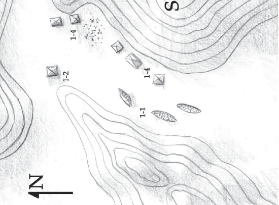
I am going to recreate a small Map that is suppose to be in the Gobi Desert. I am thinking this is town or battle Map scale.. and I will show a snippet here of what I am trying to create and make better with color etc. I am looking for thoughts from those who know more than I about which style to use and do I go with Dungeon, City, or Overland to create this..I am leaning towards Dungeon as long as I can find the tent symbols and something to indicate the elevation changes.
Comments
I should add though not visible there is a cave on this map towards the top but I was going to do that as a separate map and perhaps just show the entrance on this map.
Following this thread because I have the same question for a down-the-road map. Looking forward to everyone's suggestions.
Not quite sure about the scale of the map you're emulating, but as you mentioned "tents", I think you're probably right to go with a Dungeon-scale map.
As for the drawing style, that really depends whether you want something a little abstract, but clear - like the drawing you've shown - or something more nearly photo-realistic, or something between the two. Plus what you think looks best among those options, of course!
Another element of this may be exactly how the map will be used, as that could determine how clear you need the various elements to appear - if the slopes are important for movement, for instance, you may need to use variant shading/colouring to make clear for players where there are difficult terrain areas, say (loose sand, hard rock, etc., and perhaps not just on the slopes from the dot-shading in the valley near some of the presumed tents).
The Scale is sort of in between which is why I question..But i think I am going to use it like an investigative battle map and let the players wander around it so thinking dungeon scale. As far as style I was thinking less abstract more immersion aka realistic. Honestly slopes are no that important though there are things on the other side of a hill that will not be visible until you climb to the top but i can deal with that using layers or VTT dynamic lighting. I was hoping to use something to indicate elevation other than a hill symbol..though I guess some really large hill symbols might work.
This is why I mentioned it was the Gobi Desert so a combination of sand rock and some brush. If I am not mistaken.. Below one of many images I found of the Gobi.. very sandy though there are some brush areas. This is suppose to be a fictional area caleld the singing hills so I am thinking the first image is closer to what this should look like..
For the elevation, you may be better using something like the shaded relief techniques, as discussed recently in this Forum topic. But if you're going with more rocky terrain (or areas of rocky outcrops), symbols probably will work better to convey rough, variable cliff-lines. I'd assumed from the density of contour lines on your base map that the hills were going to be key features, as they're suggestive of something steep and high.
Like most deserts, the Gobi has a variety of terrains, so just pick something that appeals and run with that!
For more realistic drawing styles, and assuming you have plenty of the Cartographer's Annuals available, take a look at the thumbnail images on Sue's topic which shows all the CA issues in one place - here. That should help you start narrowing down to a style you think fits best with what you have in mind. Even if you only have the base DD3 installed, you can find materials to work with there to create what you need, though you may need to be a bit more creative in how you use the various tools and symbols, and may need to draw more, where there aren't enough symbols of the type you need.
Aye I have all the annuals I will take a look at Sues.. Aye perhaps a few ridge indicators would be enough as on hill if steep but others not so much and are meant to be searched.
Found an awesome one for snow. Still looking for the right one will post once I do and what I come up with.
Something that allowed me to create something like this would work.
You can certainly get an effect like that just using the normal DD3 symbols and drawing tools. I did something of the sort for Wyvern Citadel in the Community Atlas in 2021. The Forum topic on that's here, which gives an idea as to how I arrived at the final concept. That's shown on this shot of the ground level of the fortress (which shows the cliff lines the clearest):
There are higher res versions of all the maps in my Gallery, while you can pick up copies of the Atlas FCW files for the drawings here.