

[WIP] Bā Dà Chéng Shì
 JulianDracos
Mapmaker
JulianDracos
Mapmaker
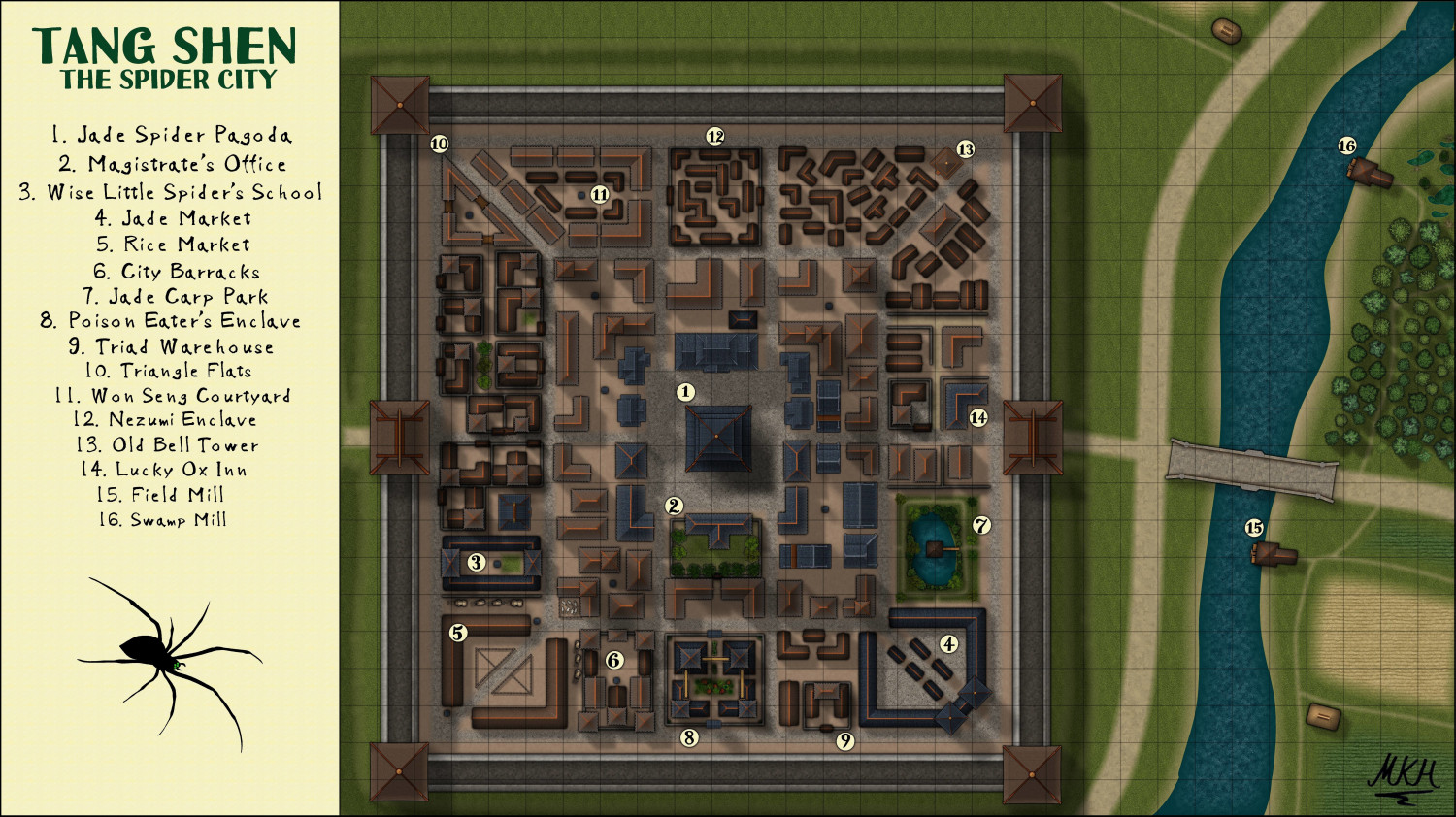
So after seeing Tang Shen https://forum.profantasy.com/uploads/968/ACAJWSNFB9OU.jpg I decided to try my hand at an Asian Style city. Since 8 is a lucky number in Chinese, I made it 8 sided.
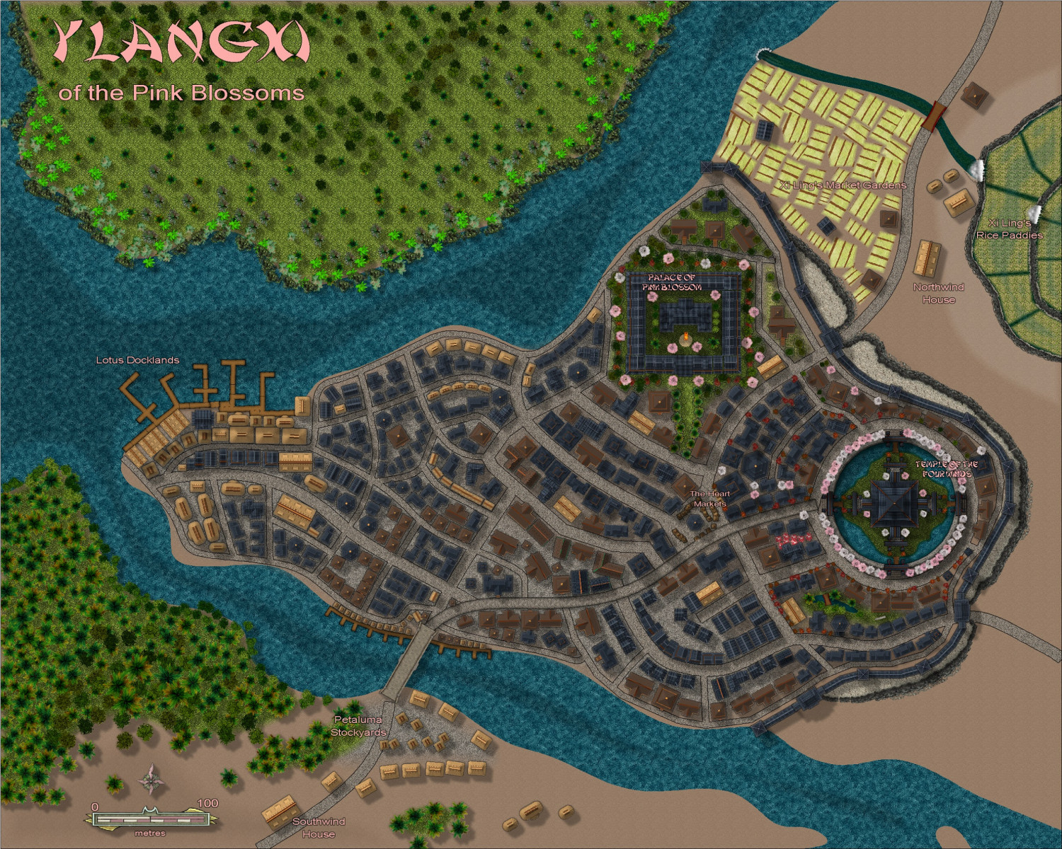
Then, https://forum.profantasy.com/uploads/881/DI0Y02K8GQ3G.jpg comes along and takes things up another notch.
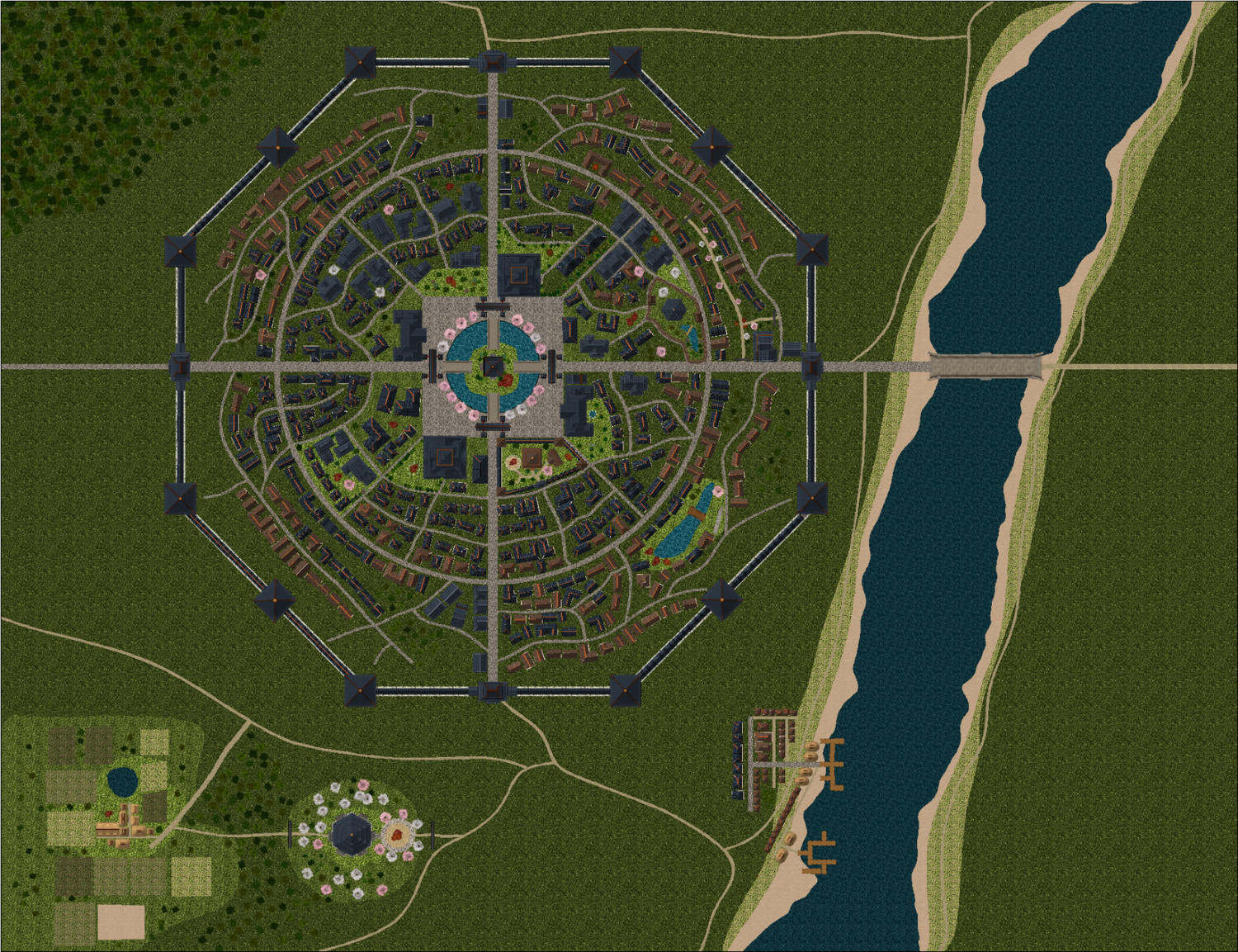
So I am working on the city and I have sort of reached an end point of not know what else to do in terms of making it look more impressive. Part of it is that I think some of the details are lost by having more of a region covered. But I think most of it are small things like the color of the background or perhaps lack of geographical features. I tried making the grass in the city a little lighter, but I didn't think it provided as much contrast to the lighter grass in the city.
Anyway, any suggestions on what to try?
![[Deleted User]](https://secure.gravatar.com/avatar/c75d9a245b74d9c59be0999ea81ca541/?default=https%3A%2F%2Fvanillicon.com%2F92add7f8c954488718110edc4896ad39_200.png&rating=g&size=200)


 and 1 other.
Comments
It looks pretty good :)
However, this was one of my earlier styles and lacks quite a lot of the things I included in styles like Darklands City, which has fields, farm animals and extendable bridges. I've seen a map around the forum recently (though can't quite remember which thread so early in my morning) where I think Quenten used fields from another style to fill out the details on a map in this style. You don't have to use the same combination. There are lots of other styles with fields.
What does it look like with the sheet effects turned on?
EDIT:
I can't really tell at this scale, but it looks like you might have an issue with the colour of the polygon hiding behind each house symbol and building, particularly on your city wall buildings. This colour is decided when you initially paste the buildings or house symbols depending on what colour you have active in the palette at the time - white in the case of your city wall, if I'm not mistaken.
If you temporarily hide the STRUCTURES (SHADING) layer you will discover them hiding under the roof.
You can use change properties on them in this state without harming the rest of the symbol or building. Colour 114 seems to blend much better with the background.
Then unhide the STRUCTURES (SHADING) layer and reshow everything you need, without any risk of those slithers of unwanted colour.
Slighty dumb sounding question: Are the effects turned on? I don't see any shadows, or fades in this otherwise excellent map.
Apart from that it looks awesome. You took the "Harmonic architecture"-aspect to a new level. My little spider web has nothing on this.
The right side of the river could use a bit more terrain - if you're not planning to put the map key there.
EDIT: Sue already asked about the effects. Darklands Style field textures work good around asian towns.
I haven't found a good set of fields yet. I don't have Darklands.
The effects are turned on. You can tell a little bit more if you zoom in. I think I need to increase the sheet effects for a map this size. Here is another version with the effects increased by 50% over the base. Not sure you can tell much more other than the center of the town.
I edited my comment above with a lot more information about those coloured polygons I believe may be showing outside the edges of the city wall buildings, but I really can't tell to be honest at this scale. What are your export settings?
EDIT: maybe it is a road you have under the walls?
At any rate, to generally improve the appearance of the export I recommend doubling the scale of all the textures and using either a larger exported file, or one that has had much more antialiasing. This setting, for example, will give you a map that is 3000 pixels on the longest side and show much more detail because the render will really be 6000 px on the longest side, downsized by antialiasing to smooth out the sharp bits.
Although my test map has nothing of beauty about it, this is the result of that setting on a default sized map (1000 x 800).
The fields I used were in Fantasy Town, CA169, in the 2021 Annual.
The export settings are 11x8.5 inchs at 150 PPI (72-150 is what most screens display on the internet). I have doubled the texture fills. The drawing area is 2640x2032.
I do not think there is any issue with the sheets. Zoomed in you can see the shadows. So either they effects are not big enough or there is some issue with it being zoomed out. The building shodows show up great on a white background, but seem to disappear on the dark green.
Oh, I see! :)
I thought I was looking at exported images - jpeg images rather than screen shots.
Sorry - my bad ;)
The first images I uploaded are exported images. It is only the last one that is a screen shot. I did this because I needed to zoom in and was in a hurry. Also, in case there is an issue with exporting an image that is causing the shadows to disappear. This way, you can see that there are shadows. They just aren't showing up well when exported.
I changed the background of the buildings to color 114 per @Loopysue suggestion. The green still shows through on a few buildings. I increased the sheet effects some more. If this months newsletter includes a coupon for an annual, I will pick up one that has some good field options to use.
I am not sure why the roofs of the walls on the top left and bottom right have an orange line and the other ones do not. I will have to look into that.
Is this one an export?
The resolution you are exporting at is really quite low. 1650 pixels on the longest side is roughly half the smallest size I export my own maps (usually at least 3000 px on the longest side, and frequently much more than that), and explains why most of the textures are only showing up as low res versions of themselves. But if that's the size you are stuck with, then that's the size you are stuck with.
If the grass is too dark to look good you can use HSL sheet effects like this one to make it paler and/or change it's colour quite dramatically, though if you use the mixed grass and dirt textures you may have to be careful how far you take it in any one direction. I tend not to use those mixed ones myself because they make it tricky to change just the grass colour, or just the dirt colour.
If I was able, I might revisit these two styles and redo the textures, but that's how they're fixed. You could try importing fills from other city styles to use instead of those that come with the style...
There is a 10 MB upload size and putting maps at 300 PPI tends to make it go over. Also why I have to use JPEG instead of PNG. I was able to tweak the settings to get things just below the 10 MB limit but keep it at 300 PPI. Not sure if it will look much better to you.
I am going to play with the background of the city a bit.
In some ways that looks better, but in others it actually looks slightly worse. There's a moiré pattern developing in the roof textures at that particular resolution that may disappear if you edge the resolution a couple of pixels lower?
What are your settings exactly? I have been exporting images at 4 and 5 thousand pixels on the longest side as jpgs and only getting about 6MB files.
For the file that just uploaded: W: 3300 H: 2550 Resolution: 300PPI
Print Size 11x8.5
AA:0%
When I have AA set higher than that, it goes above 10 MB at this resolution. It was ~20 and the file size was 14.5 MB.
Previous resolutions for 50% (150 PPI) with AA at ~20%. File size was much smaller.
That's interesting. I didn't know that bringing up the AA would increase the file size.
This is a 6000 x 6000 px image exported at 85% JPG Quality. As you can see from the little pop up info thing on the file I have selected, the size is well below 10MB. I use anything between 20 and 66% aa as a matter of course.
EDIT: the only thing that limits how much AA I actually use is the "Work size" you can just about see in tiny letters at the bottom right here. I make the AA as high as I can, while keeping that size under 10,000 x 10,000
EDIT 2: I never export as png anymore. File sizes are just way too large. jpg is the way to go if file size is important.
Just a note aside here...
If you are looking for an opportunity to get another add on, perhaps with fields and other things that might be lacking in this particular style, there's a 15% off offer available in the latest email newsletter. It's meant to let people get SS4 if they haven't already got it, but if you want something else instead on that offer the email does say to reply to that email and ask for what you really want and PF will see what they can do.
It does depend on whether you receive the emailed newsletter, though, since it specifies by reply to that email.
I forget which template I used, but noticed an orange glow. The symbols were on the cartouches sheet. I moved them to the text sheet as I wanted that outer glow on them.
This was compass rose and scale. But my text sheet has either a color 15 or color 0 on it.
Adjusting the antialiasing setting can increase file size for PNG exports because the compressor for PNGs relies on converting patterns of colors into a smaller representation. Increasing the AA setting gets fewer identical pattern blocks, which means fewer opportunities to use smaller representations. PNG can't toss out anything, so more information in the input requires more information in the output.
JPEG, on the other hand, does a transformation on blocks of pixels and lets you pick how much "unimportant" data to throw away. Throwing away some input data is why decompressed JPEG files tend to have very specific kinds of errors.
That's really useful to understand. Thanks, Joe :)
I am waiting to see about using the discount for something other than SS4. In the mean time, I have updated the map.
I have no idea why some of the city walls have the orange line and some do not. When I zoom in, they all have it. Depending on the zoom level, some show and some do not. I am thinking I may have to manually put in wall symbols there. Those, however, do not have the orange line but I think it would be better to have none of them with the orange line than some of them.
I changed the background of buildings to green. Some of that is showing through.
I am thinking I need to add some more effects for the river to help it pop.
Once I get another annual, I will change out the fields. Not really sure what else to do after that to make it look better.
This is exported in 300 PPI w/ AA turned out to ~30%. I reduced the JPEG from 100% to 95% and that has made the file substantially smaller. I am not a fan of JPEG and prefer PNG, but JPEG does make file size smaller.
Its coming along really nicely :)
You mention orange lines on some of your wall buildings.
Can you zoom right in and show us what it looks like?
Only time I have seen an orange glow is on the Cartouche sheet.
You know when you make houses, there is the orange line on top for the roof? I used the house command to make the top of the walls and it had the orange line. Sometimes it is there and sometimes it is not depending on the level of zoom. It should be on the top of every wall. I had to use the export image for this. If I were to zoom in with CC3 to this level, then the orange line for the roof would be visible on every wall.
The orange line is the roof ridge for that style (It looks better when you zoom in much further). The reason it sometimes seem to disappear when you zoom out is that it simply becomes to narrow. Your screen only have a finite amount of pixels, and when something gets thinner than a single pixel, a decision will be made if that pixel should be displayed or not. Being less than a pixel, if you use a pixel to display it, you take away space from something else, so showing everything is simply not a technical possibility.
The same is the case for exports. A sufficient high res export may have more than one pixel available for each ridge, eliminating the problem, but generally, every export will have it's limits, just how images work.
What is weird is that I just draw one wall segment and then copied it into the other spaces. So it would seem as though either all would show or none. I guess it depends on the location.
I am experimenting with trying to make some rice paddies. Thoughts on my first attempt?
The roof ridge lines can look different widths at different angles.
Rice paddy: I get the muddy water and dotted rice plants, which are great, but what is the boundary?
The boundaries are bushes. When looking at images, they often have some type of plant boundary.
Oh I see!
Maybe make the boundary a bit less regular, with mixed bushes and a few small gaps here and there?
So I have attempted a new way of doing this.
The pit effect is weird. It is not showing up in CC3, but I can deal with that later. Also, the bottom retaining wall needs to be move closer.
In any case, I could move the incoming water above the terrace and add a waterfall down to the next level. Wondering if the greenish water needs to be made more brown or blue around the edges.
Another thing I am considering is drawing more irregular terraces. Those exist on the mountainside, but not usually when you are just flooding a field. Perhaps making the retaining walls look more like just piled rock would help. Here is a zoomed out view.