


Monsen
Monsen
About
- Username
- Monsen
- Joined
- Visits
- 723
- Last Active
- Roles
- Administrator
- Points
- 9,029
- Birthday
- May 14, 1976
- Location
- Bergen, Norway
- Website
- https://atlas.monsen.cc
- Real Name
- Remy Monsen
- Rank
- Cartographer
- Badges
- 27
Latest Images


-
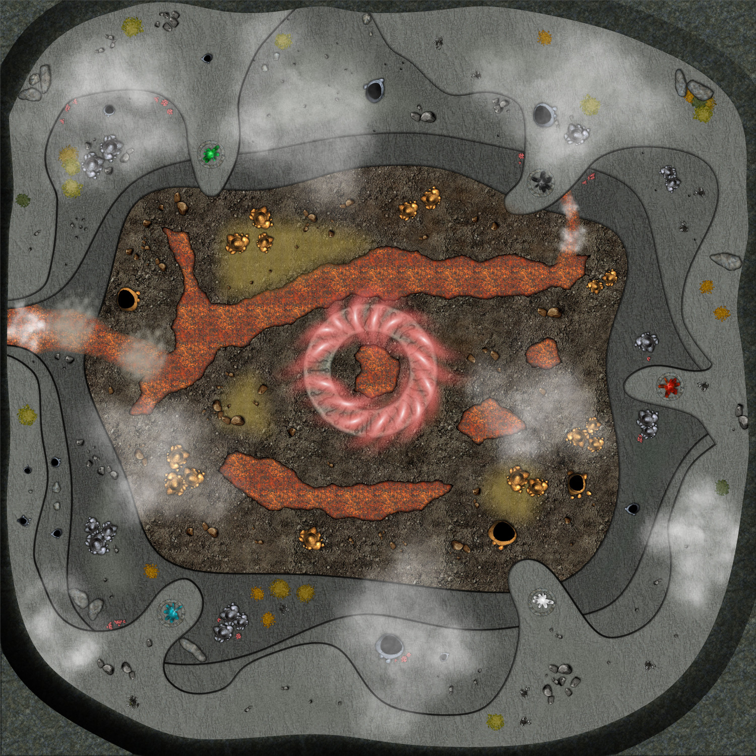
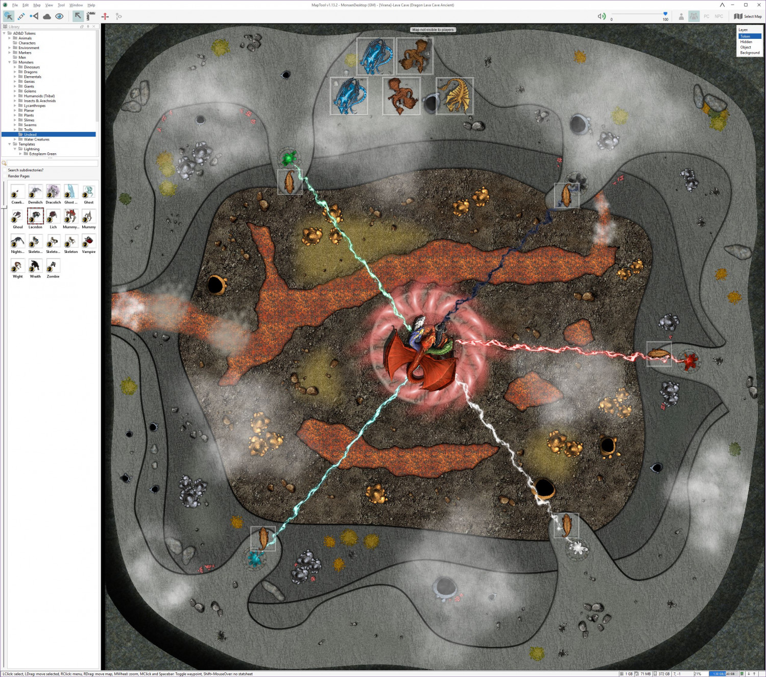
Live Mapping - Lava Caves & Virtual Tabletops
I didn't finish the map during that video back then (Nor did I really expect to, since I spent a lot of time talking about map usage, scale, and other VTT considerations), but as the session where I need this will be this weekend, I have finally finished it.
There are still several things I am not too happy about with this map, in particular the transitions between the different levels, and the symbols doesn't flow with the terrain nearly as well as I could have wanted, but I had to balance several considerations, among them making the map clear and easy to read when loaded into a VTT, how much time and effort I could reasonably use for a single encounter, as well as for the fact that while I am a master in the technical side of mapping with CC3+, the visual arts is not really my strong side. So I guess this is what I consider a "Meh, good enough for it's purpose" map.
I could have made the map a bit more atmospheric by making it darker, and perhaps used some dungeon lighting to make a nice glow from the lava, but I am using it on a projector in a lit room, which means it will be far more usable if it isn't too dark, and have a good level of contrast.
Note that this map is pretty huge for a battle map, 500 by 500 feet, which means 100x100 squares if using the standard 5' battlemap squares. A standard human character (movement 12) would need 4 full rounds just walking in a straight line from one side to the other, before considering any terrain movement restrictions.
I've put links for larger versions of each image.
Here's the finished map in CC3+ (Larger version [7500x7500 pixels])
Here's the CC3+ file for it.
And here is the finished map in MapTool, ready to play (Large Version [2544x2248 Pixels])


-
[WIP] Community Atlas - Rhaghiant (western Doriant)
When it comes to symbol sizes, I think an important part of a map is that information is legible when zoomed out. Exactly how large that is depends on the map obviously, but in most cases, it will mean the symbols will be covering more area than the settlement actually takes up.
Currently, the settlement symbols do look a bit small IMHO. They don't have to be scale 1, but I think they could probably be 0.5.
More "precision" is usually better done by making a new local map from parts of the main map, which can show more details, and "more correct" settlement scaling. Exactly where the cutoff point for detail level lies between those maps of course differ based on the map itself.
-
Username Change
How do you log into the forum? If you use the google social logins it will automatically grab the name from the google profile, there is no option to change that.
If you wish to use another username, you must log in using the forum's own username/password login.

-
Community Atlas Project - Download information - Contributions Welcome
If you want a smaller area, I suggest you look at an area on one of the existing regional maps rather than straight on the continent map. That should allow you to find something more akin to the scale it sounds you are looking for. Or you can make 2 maps, do this larger scale one, and then develop a section of that map further on the second map.
But as for adding features like a lake, of course. The basic premise with any atlas is that there will always be features that are too small to appear on the higher level maps, that will only appear on a detail. Main idea here is to just keep it small enough that it wouldn't realistically appear on the world map (Which in general would mean smaller than any lake that do appear on that map.) But do make sure to add lots of interesting features, that's part of the fun, and allows other mappers to make interesting detail maps from your map.

-
Community Atlas Project - Download information - Contributions Welcome
Thanks for joining in @Kertis Henderson
As Quenten said, just go ahead. I won't register the claim in the atlas right now, but there shouldn't be anyone else desiring that area presently.
One hint about that area though, even if it is a small area of Doriant, Doriant is a huge continent, so that area is pretty large. About 500 by 350 miles, or 175 000 square miles, almost the size of the entire country of France, or a bit larger than the entire US state of California. The lake is about the size of Lake Ontario. Keep that scale in mind when deciding which features will realistically show up on the map. Those red dots on the continent map would represent some of the biggest cities around, capitals and metropolises.

