


Monsen
Monsen
About
- Username
- Monsen
- Joined
- Visits
- 723
- Last Active
- Roles
- Administrator
- Points
- 9,029
- Birthday
- May 14, 1976
- Location
- Bergen, Norway
- Website
- https://atlas.monsen.cc
- Real Name
- Remy Monsen
- Rank
- Cartographer
- Badges
- 27
Latest Images


-
Installed Add-Ons List
With the exception of Symbol Set 1 & 2, you'll find the entire list in the Tools menu -> Add Ons
Only way to check SS1 and 2 is to go into the new map wizard, and under overland and dungeon respectively, see if you have templates for these.


-
Pseudo-Architectural Shenaningans (WIP)
That CAD Blocks site has a lot of good stuff. I've added it to the list in the Free Symbols resource thread.
These CAD blocks are actually ready to use symbol catalogs, which is very neat. I first thought I would have to resort to just copy/paste from the drawing, but load them up as a symbol catalog, and they show up as proper symbols.


-
October Community Challenge - City Streets - VOTING POLL in first post
I'll probably never to cities as competions. The most common thing I hear every time someone announce a challenge or competition is "sorry, I just don't have time right now, working on this other map/real life/etc...". And cities are one of the most time-consuming things out there, which certainly wouldn't help with people having time to take part. (And while you can do something like a Watabou city really quick, that wouldn't be much of a mapping challenge considering most of the work is just changing properties on the import, especially when all the entries are like that)
And for that two-parter idea to work, I would have to put really strict rules into place regarding how to build the city for part 1 for it to be suitable, I don't think that is really going to work out well.
-
Cosmographer Deckplan issues
The tools are all set up with a mirror line of 0 degrees as default which results in the ship being mirrored along the X-axis
If you wish to draw a ship withe the nose pointing up, right click :COSHULL:, look for the tool to use, note the name mentally, then hit the Advanced button and select the tool you wanted in the list to the left.
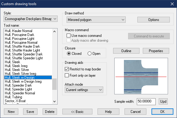
Now, hit the Options button, and set the mirror line angle to 90 degrees. (Obviosuly, this is only possible for tools that have Mirrored Polygon as the draw method)
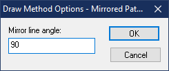
Hit OK, and then Hit OK again to start drawing. Say no when it asks you to save your changes, otherwise the tool will be permanently modified.
Then just draw your hull.

-
Cosmographer Deckplan issues
It's the snap setting. Snap and Cursor snap is on, but for some reason, no grid is selected. This basically causes everything to snap to 0,0 and nowhere else.
Right click the snap button in the lower right, and click on one of the existing snap grids in the list (or create a new one)

