Monsen
Monsen
About
- Username
- Monsen
- Joined
- Visits
- 726
- Last Active
- Roles
- Administrator
- Points
- 9,029
- Birthday
- May 14, 1976
- Location
- Bergen, Norway
- Website
- https://atlas.monsen.cc
- Real Name
- Remy Monsen
- Rank
- Cartographer
- Badges
- 27
Latest Images


-
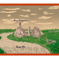
[WIP] DOTR The End of Castle Wittgenstein
Unfortunately, the symbols in area don't obey the random rotation symbol properties.
As for steampunk, nothing in the official symbols as far as I can remember. Would have made a nice annual though.
-
Is there a way to scale hatch fills?
The Hatch style is set in the Outline options for the tool.

-
Scale and exporting from Fractal Terrians
The map exported from FT3 should be in the correct scale already.
The scale bar may be wrong, that's a known bug. Try to measure the actual distance with the Info -> Distance tool.
Also note that map projection can also affect scale. FT3 exports the map using the current map projection. Depending on the projection, areas nearer to the poles may be distorted/enlarged (like Greenland in the real world). If this is the issue, try using another projection in FT3 when you export.


-
Mapping contest reminder
Hi everyone,
This is just a quick reminder that we have now hit February, so it is now slightly less than one month left of the competition. Still plenty of time to make a nice map.
For those not aware of the competition, all the details are in this topic. But in short, it is a competition with prizes where the idea is to make a dungeon with a fire and/or ice theme.
The absolute simplest way of participating is to make a level for our mega-dungeon, which only have one basic requirement, since it is going to be one of many levels in a large dungeon, it should have exactly one entry in from above, and one exit going further down into the complex. Rest is up to you.
If you are unsure about anything, please don't hesitate to ask. I'll rather answer a few questions than having people not participating because things were unclear. I know there is a lot of text on that other post, necessary to ensure everything is clear, but this is intended as a contest for every CC3+ user with a low bar of entry.
So, please join in on the fun. I'd love to see lots of entries for the contest.
Remember, all entries must be posted in the main contest thread before the end of the month of February. The entry is just an exported image in a decent resolution of your dungeon, and optionally the .fcw file if you wish to allow the dungeon to be used in the community atlas, but that last part is optional.
And if you need some ideas for how to do things for a ice cave, check out my recent live stream.
-
What kind of music do you listen while mapping?
Critical Role is cool. I prefer watching the actual stream recordings and not just the podcast, since there is much visual information in the videos and on-screen goofing. Works great when run on a second screen, because it doesn't require your full attention.