


Monsen
Monsen
About
- Username
- Monsen
- Joined
- Visits
- 723
- Last Active
- Roles
- Administrator
- Points
- 9,029
- Birthday
- May 14, 1976
- Location
- Bergen, Norway
- Website
- https://atlas.monsen.cc
- Real Name
- Remy Monsen
- Rank
- Cartographer
- Badges
- 27
Latest Images


-
Community Atlas 500th map and 4 year anniversary competition with prizes.
Great. Thanks for the submission.

-
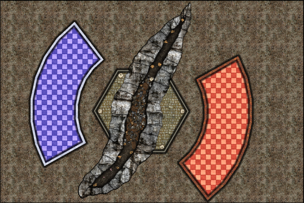
Atlas Competition - The Divide
Obviously lots to do with this one yet, but I've now added a broken room across the chasm, and some hot and cold rooms on either side. I am using the color key effect to let the chasm break the hexagonal room. Floor colors in the two rooms are provided by a simple RGB Matrix effect, just increasing the amount of blue and red respectively. Might not be the final fill, but I needed a placeholder to guide me.


-
FRIA Install Problem
Easiest is to just install patch 3. Unless I remember incorrectly, Patch 3 doesn't require the CD, and should be the only one you need (see my previous answer above)


-
Atlas Competition - The Divide
Finally had the time to start on my own map. It will be a simple level for the mega-dungeon.
The map is divided into two halves by a chasm, with a fire giant being trapped on one side and a frost giant on the other side (maybe they will morph into wizards or elements or something later, let's see as the map progress).
So far, I've only just started on the chasm dividing the map in two.


![[Deleted User]](https://secure.gravatar.com/avatar/c75d9a245b74d9c59be0999ea81ca541/?default=https%3A%2F%2Fvanillicon.com%2F92add7f8c954488718110edc4896ad39_200.png&rating=g&size=200)

-
Mapping Competition - Final Week
Well, just one more week to go for our mapping competition. Time to start thinking about finishing up your maps. To make it easier time-zone wise, I am going to accept any entries that arrives in the main contest thread while it is still February somewhere (Quibbling individuals have to adhere to 23:59:59 CET February 28th).
That said, a week is still plenty of time to make a map if you can find a couple of hours to work on it, so if you haven't started yet, there's still time. If you are still unsure, I say go for it. Competitions are a fun way of challenging yourself.
If you don't have any ideas, remember that the simplest option is to simply make an ice or fire themed level for our mega dungeon. Even if it is a mega dungeon, it doesn't mean that each level have to be huge. Only requirement here is a single entrance from above, and a single (reachable) entrance going down to link it up with the rest of the levels. Your level doesn't have to be more than a couple of rooms, whatever you have the time
Check the first post in the main thread for a list of links of those who have already submitted their map.
