


Monsen
Monsen
About
- Username
- Monsen
- Joined
- Visits
- 723
- Last Active
- Roles
- Administrator
- Points
- 9,029
- Birthday
- May 14, 1976
- Location
- Bergen, Norway
- Website
- https://atlas.monsen.cc
- Real Name
- Remy Monsen
- Rank
- Cartographer
- Badges
- 27
Latest Images


-
CC3 climate view
I talked to the developer, and the issue here is that the underlying windows API functions that handle the actual painting to the screen is hitting their limits, the multipoly simply gets too complex in this case.
The only option is to reduce the number of nodes in the underlying polygons. to reduce the complexity.

-
CC3 climate view
CC3+ files generated from FT tends to get a bit big, because of all the nodes.
The forum should support attachments up to 5MB, and it does allow compressed files, but only .zip. (This is done intentionally to encourage people to use that format. Not because it is the best compression-wise, but because every modern OS has built-in support for it, so a .zip file is usable by everyone without looking for additional software.)
You can just email me the file though, you'll find my email in my profile. I am pretty sure the attachment limit for email on google is 20MB.
-
CC3 climate view
Could you attach the .fcw here? I'd like to have a little look at it, and see if I can replicate the problem on my computer and have a look at those problematic polygons and maybe send it off to the devloper.

-
[CC3+] How to stop Campaign Cartographer from changing my active drawing sheet?
This does not sound like intended behavior, CC3+ should not switch to Common for anything. It would be good if you could just check a few things for me.
First of all, are you sure your entities actually end up on Common? I am asking because there is a visual glitch that sometimes incorrectly show "Common" in the status bar, even if another sheet is selected, but the entities normally end up on the right sheet.
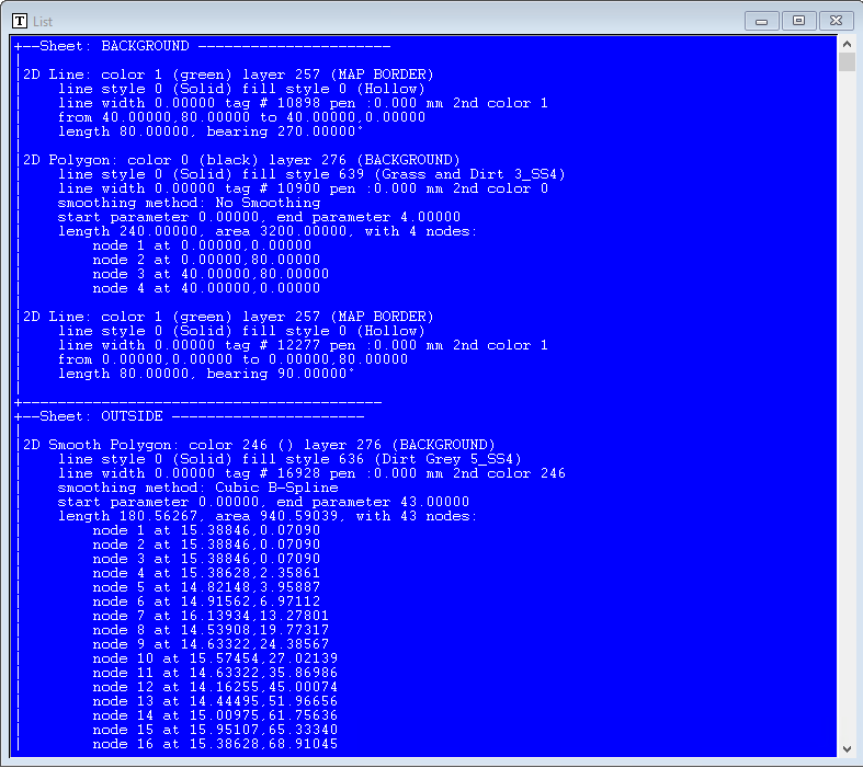
You can easily check this by using the List command from the info menu on the entities. If the output is prefixed by a sheet name like in this screenshot (Showing the BACKGROUND sheet in this case), the entities are on the listed sheet, but if there are no sheet name at the top, they are on Common. (Note that you can still select entities even if you can't see them, or you can do this right after placing an entity before doing the refresh that updates the display and makes it hide. You can also just hide the sheet your image is on.)
Secondly, what sheet is your image on, and where is that sheet in the sheet order (If unsure, you can use the list command from above on the image). Try moving the sheet with the image to the very top of the list of sheets (right below Common) and try doing a bit of mapping now.
-
Sheets to Symdefs
Doing sheets to symdefs is only intended to be used with symbol catalogs, and not maps, as it basically take each sheet and turn it into a symbol definition. This isn't easy reversible, because running the reversing command, symdefs to sheets, will not just turn those symbol definitions you made back into sheets, but it will also turn the symbol definitions of the actual symbols in the map into sheets, meaning they will disappear from the map. Considering you also said you deleted some symbols might also mean that you may have removed the actual content of the map, since it was reduced to symbols for the time.
I am afraid that the only resolution here is to restore an earlier copy of the map from backup if you have any. You can try to post your .fcw here for someone to have a look at, but I am suspecting that when you saved the map earlier, it became unrecoverable.
