Monsen
Monsen
About
- Username
- Monsen
- Joined
- Visits
- 723
- Last Active
- Roles
- Administrator
- Points
- 9,029
- Birthday
- May 14, 1976
- Location
- Bergen, Norway
- Website
- https://atlas.monsen.cc
- Real Name
- Remy Monsen
- Rank
- Cartographer
- Badges
- 27
Latest Images


-
Selecting multiple entities using entity tags
Unfortunately, it doesn't support ranges.
Maybe doing selections by name instead will help? (It's a bit down the page in the article)

-
HELP - My houses are a single color block, still pretty new
Your buildings have entities on the wrong layer. This is probably caused to how the random building/street command works. The correct layer is set when the symbol catalog is loaded, so if it changes after that, it can cause issues with this command. It can be worth checking that the correct layer is set every so often.
Fortunately, it is easy to fix.
To fix it for future placements, simply change the layer shown in the status bar to one of the city demographics layers; the ones named BLDNG (XXX).
To fix buildings already placed in the map, either simply delete and recreate them, or use the Change House Layer command found in the City menu on them. Note that after selecting the buildings and Do It, the command line will prompt for a layer. the easiest is to right click inside the map to get the layer dialog, then pick the appropriate demographic layer, hit OK, and when back in the map, hit the refresh button to update the display to actually see the change.

-
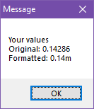
Macro square root calculation
I can't remember if there is a better way off the top of my head, but you can control the number formatting pretty well if you do it manually, like in my simplified and overly verbose example here:
MACRO TTT
GV a 1/7
GN b a*100
GN c a/100
GV d a-c
GN e d*100
GL out Your values
APND out
APND out Original:
APND out a
APND out
APND out Formatted:
APND out c
APND out .
APND out e
APND out m
MSGBOX Message;out;
ENDM

-
an odd background
This bitmap isn't really intended to be used as a main background, rather it is meant to be used with drawing tools to draw patches of heath on top of your terrain background.
One limitation with CC3+ is that fills can't be categorized. So the background fill picker in the new map wizard will simply show all the bitmap fills available in the map, it has no idea which fills are suitable and which are not.
-
Macros getting errors calling lables
While not the most advanced debugging feature in the world, you can issue to the STEP command to help debug a macro and see what is going on. It will show you a message box for each line run with the variables expanded so you can see exactly what is being called.
It can be turn off again with NOSTEP